 My GeoNetwork catalogue
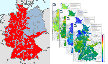
Summarised presentation of the results of the geochemical investigations in Germany in the period 1975 - 1986, Nickel in stream sediments, Single element maps
Between 1975 and 1986, geochemical investigations were carried out by the Federal Institute for Geosciences and Natural Resources (BGR) on the territory of the then Federal Republic of Germany and by the Central Geological Institute (ZGI) of the former GDR in the area of the pre-Upper Permian bedrock units in the southern part of the former GDR, which lie on the earth's surface or are slightly covered by the Cenozoic. Approximately 98,000 water and 87,500 stream sediment samples were taken and geochemically analysed. The results of these investigations were published in the "Geochemical Atlas of the Federal Republic of Germany" (Fauth et al., 1985) and in the "Final Report on the Comparative Evaluation of the Raw Material Potential in the Bedrock Units of the GDR" (Röllig et al., 1990; in German). The geochemical data collected as part of these investigations, which cover a large part of the area of today's Federal Republic of Germany, are unique in their high sampling density. All subsequent geochemical investigations were carried out with a much lower sample density. These valuable and irretrievable data have been generally accessible via the BGR geoportal since their digital processing and provision in 2022 (Geochemical Atlas of the Federal Republic of Germany) and 2023 (Geochemical Prospection in the bedrock units in the southern part of the former GDR). However, a direct comparison of the maps produced for the two sub-areas is not possible due to the differences in the analytical methods used in the investigations (investigated element spectrum, analytical quality, determination limits, ...). Nevertheless, for some of the investigated elements and parameters it is possible to summarise the results of these geochemical investigations, which are unique in their high occupancy density, with appropriate adjustments (determination limits, representable content ranges, classification of the map legends, ...). Such summarised representations are now being made available for the first time via the BGR geoportal. The downloads show the distribution of Nickel contents in stream sediments in four different coloured point and colour shaded contour maps.
- Identification
- Distribution
- Quality
- Spatial rep.
- Ref. system
- Content
- Portrayal
- Metadata
- Md. constraints
- Md. maintenance
- Schema info
Identification
Data identification
Citation
- Alternate title
-
SumPresGchD7586, Ni in stream sediments, Single element maps
- Date (Publication)
- 2024-04-30
- Citation identifier
- https://registry.gdi-de.org/id/de.bund.bgr.csw/5bb9cdac-221f-42cb-9ef6-621d47dc6571
- Status
- Completed
- Theme
-
-
Atlas
-
Bachsedimente
-
Geochemie
-
Geochemische Karte
-
Elementkonzentration
-
Nickel
-
flächenhafte Verteilung
-
Prospektion
-
Umweltgeochemie
-
atlas
-
stream sediments
-
geochemistry
-
geochemical map
-
element concentration
-
spatial distribution
-
prospection
-
environmental geochemistry
-
- Place
-
-
Deutschland
-
Germany
-
Legal constraints
- Access constraints
- Other restrictions
- Other constraints
- Es gelten keine Zugriffsbeschränkungen
Legal constraints
- Use constraints
- Other restrictions
- Other constraints
-
Allgemeine Geschäftsbedingungen, s. https://www.bgr.bund.de/agb - General Terms and Conditions, s. https://www.bgr.bund.de/agb_en
- Denominator
- 2000000
- Language
- Deutsch
- Character set
- UTF8
- Topic category
-
- Geoscientific information
))
Distribution
Distribution
- Distribution format
-
-
Shapefile
(
n/a
)
-
PDF
(
n/a
)
-
PNG
(
n/a
)
-
Shapefile
(
n/a
)
- OnLine resource
- Original-Publikation
- OnLine resource
- Environmental aspects of the regional geochemical survey in the southern part of East Germany
- OnLine resource
- Daten (BRD)
- OnLine resource
- Daten (DDR)
- OnLine resource
-
SumPresGchD7586 - Ni (Shape)
SumPresGchD7586 - Ni im Format ESRI Shape
- OnLine resource
-
SumPresGchD7586 - Ni (PDF600)
SumPresGchD7586 - Ni im Format PDF600
- OnLine resource
-
SumPresGchD7586 - Ni (PDF300)
SumPresGchD7586 - Ni im Format PDF300
- OnLine resource
-
SumPresGchD7586 - Ni (PNG600)
SumPresGchD7586 - Ni im Format PNG600
- OnLine resource
-
SumPresGchD7586 - Ni (PNG300)
SumPresGchD7586 - Ni im Format PNG300
- OnLine resource
- Karte im BGR-Geoviewer
Quality
Data quality
Scope
- Hierarchy level
- Dataset
Conformance result
Citation
- Date (Publication)
- 2010-12-08
- Explanation
-
siehe dazu die angegebene Durchführungsbestimmung
- Statement
-
Fauth, H., Hindel, R., Siewers, U. & Zinner, J. (1985): Geochemischer Atlas der Bundesrepublik Deutschland. Verteilung von Schwermetallen in Wässern und Bachsedimenten.: 79; Stuttgart (Schweizerbart Science Publishers); Röllig, G., Berger, W., Birke, M., Enderlein, F., Grosche, G., Kaberdin, B., Kampe, A., Krull, P., Kruse, B., Kunz, I., Rauch, U., Rentzsch, J., Schwandtke, E., Sehm, K., Söllig, A., Thomas, U. & Wünsch, K. (1990): Abschlußbericht zur vergleichenden Bewertung der Rohstofführung in den Grundgebirgseinheiten im Südteil der DDR. Gesellschaft für Umwelt- und Wirtschaftsgeologie mbH: S. 807; Berlin (Archiv der Bundesanstalt für Geowissenschaften und Rohstoffe, Hannover, Archivnummer 1004927).
Metadata
Metadata
- File identifier
- eb5b9c17-3ce3-4ae2-84c3-feb01f33818a XML
- Metadata language
- Deutsch
- Character set
- UTF8
- Parent identifier
-
Summarised presentation of the results of the geochemical investigations in Germany in the period 1975 - 1986, Element concentrations in stream waters and stream sediments, Single element maps
27c31210-3556-4684-813f-98d4679e0aa0
- Hierarchy level
- Dataset
- Hierarchy level name
-
Geochemie
- Date stamp
- 2025-03-10
- Metadata standard name
-
INSPIRE Metadata Implementing Rules: Technical Guidelines based on EN ISO 19115 and EN ISO 19119
- Metadata standard version
-
n/a
Overviews
Spatial extent
Provided by
