 My GeoNetwork catalogue
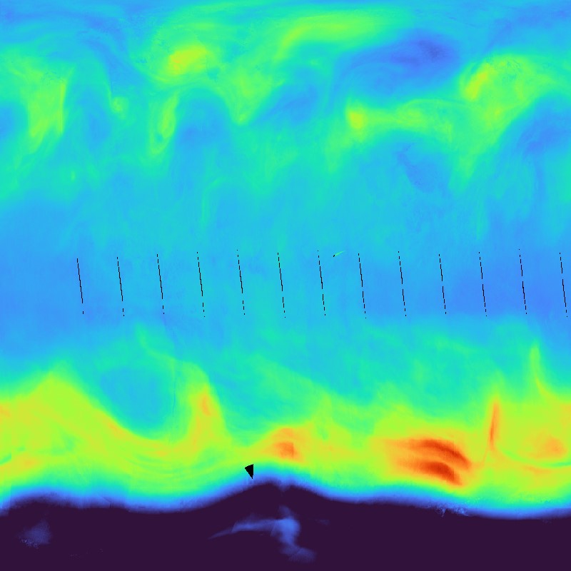
Sentinel-5P TROPOMI – Ozone (O3), Level 3 – Global
Ozone vertical column density in Dobson Units as derived from Sentinel-5P/TROPOMI observations. The stratospheric ozone layer protects the biosphere from harmful solar ultraviolet radiation. Ozone in troposphere can pose risks to the health of humans, animals, and vegetation.
The TROPOMI instrument aboard the SENTINEL-5P space craft is a nadir-viewing, imaging spectrometer covering wavelength bands between the ultraviolet and the shortwave infra-red. TROPOMI's purpose is to measure atmospheric properties and constituents. It is contributing to monitoring air quality and providing critical information to services and decision makers.
The instrument uses passive remote sensing techniques by measuring the Top Of Atmosphere (TOA) solar radiation reflected by and radiated from the earth and its atmosphere. The four spectrometers of TROPOMI cover the ultraviolet (UV), visible (VIS), Near Infra-Red (NIR) and Short Wavelength Infra-Red (SWIR) domains of the electromagnetic spectrum, allowing operational retrieval of the following trace gas constituents: Ozone (O3), Nitrogen Dioxide (NO2), Sulfur Dioxide (SO2), Formaldehyde (HCHO), Carbon Monoxide (CO) and Methane (CH4). Daily observations are binned onto a regular latitude-longitude grid.
Within the INPULS project, innovative algorithms and processors for the generation of Level 3 and Level 4 products, improved data discovery and access technologies as well as server-side analytics for the users are developed.
Simple
- Date (Creation)
- 2023-12-11T10:00:00
- Citation identifier
- https://geoservice.dlr.de/catalogue/srv/metadata/ee4623a7-013c-4afa-95cc-5703abec32aa
- Presentation form
- Digital map
- Other citation details
-
DOI: 10.15489/8yy9gz5tb356
- Status
- ongoing
- Maintenance and update frequency
- Daily
- Keywords
-
-
DLR
-
EOC
-
Sentinel-5P
-
TROPOMI
-
total vertical column of ozone
-
Atmosphere
-
Ozone (O3)
-
Daily
-
Level 3
-
opendata
-
- Use limitation
-
Nutzungseinschränkungen: Das DLR ist nicht haftbar für Schäden, die sich aus der Nutzung ergeben. / Use Limitations: DLR not liable for damage resulting from use.
- Access constraints
- Other restrictions
- Other constraints
- Es gelten keine Zugriffsbeschränkungen
- Use constraints
- Other restrictions
- Other constraints
-
Nutzungsbedingungen: Lizenz, https://creativecommons.org/licenses/by/4.0 / Terms of use: License, https://creativecommons.org/licenses/by/4.0
- Other constraints
-
{"id": "cc-by-4.0",
"name": "Creative Commons Namensnennung - 4.0 International (CC BY 4.0)",
"url": " http://dcat-ap.de/def/licenses/cc-by/4.0 ",
"quelle": "Copyright DLR (Year of download)"}
- Spatial representation type
- Grid
- Denominator
- 2000000
- Language
- Deutsch
- Character set
- UTF8
- Topic category
-
- Climatology, meteorology, atmosphere
))
- Begin date
- 2018-04-30T00:00:00
- Unique resource identifier
- EPSG:4326
- Distribution format
-
-
GeoTIFF
()
-
GeoTIFF
()
- OnLine resource
-
Atmos - TROPOMI / S5P Webpage
(
WWW:LINK-1.0-http--link
)
Project Website
- OnLine resource
-
Atmos - TROPOMI / S5P Webpage Calendar
(
WWW:LINK-1.0-http--link
)
Project Website Quicklook Calendar
- OnLine resource
-
EOC Geoservice Map Context
(
WWW:LINK-1.0-http--link
)
EOC Geoservice Map Context (s5p:tropomi:l3)
- OnLine resource
-
EOC Download Service
(
WWW:LINK-1.0-http--link
)
Sentinel-5p Tropomi L3 Download Service - EOC Download Service
- OnLine resource
-
S5P_TROPOMI_L3_P1D_O3
(
OGC:WMS
)
WMS Access: S5P L3 Ozone (O3)
- OnLine resource
-
S5P_TROPOMI_L3_P1D_O3
(
radiantearth:stac
)
EOC STAC Collection
- OnLine resource
- https://geoservice.dlr.de/eoc/atmosphere/wms?SERVICE=WMS&REQUEST=GetCapabilities ( OGC:WMS-http-get-capabilities )
- OnLine resource
- https://geoservice.dlr.de/eoc/atmosphere/wcs?SERVICE=WCS&REQUEST=GetCapabilities ( OGC:WCS-http-get-capabilities )
- OnLine resource
- EOC Geoservice Dataset
- Hierarchy level
- Series
Domain consistency
- Measure identification
- INSPIRE / Conformity_001
Conformance result
- Date (Publication)
- 2010-12-08
- Explanation
-
See the referenced specification.
- Pass
- Yes
- Statement
-
The input data for the L3 product is the Sentinel-5P TROPOMI Level 2 product "L2__O3____"
- Description
-
Processing: Data aggregation of L2 datasets with UMAS into global equirectangular L3 grids of 0.1 deg resolution based on a nearest neighbour approach, with propagation of retrieved main variables, number of observations, quality assurance and uncertainties.
- File identifier
- ee4623a7-013c-4afa-95cc-5703abec32aa XML
- Metadata language
- English
- Character set
- UTF8
- Hierarchy level
- Series
- Hierarchy level name
-
Dataseries
- Date stamp
- 2025-06-30T08:55:04
- Metadata standard name
-
19115-1:2014/19139
- Metadata standard version
-
1.0
Overviews

Spatial extent
Provided by
