 My GeoNetwork catalogue
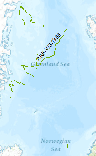
Processed seismic data of Cruise ARK5/3 1988
In July/August 1988 a seismic reconnaisance survey was carried out with F.S. Polarstern on the perennially ice covered East Greenland shelf between latitudes 73°N and 81°N. The data format is Society of Exploration Geophysicists SEG Y. 14 reflection seismic lines with a total length of 2.016 km and 12 sonobuoy refraction profiles were recorded. The following results were obtained: •On the wide Holm Land shelf province north of 79°N three possible Cretaceous rift basins were observed. •A buildup of layered extrusive basaltic rocks forming a wedge of seaward dipping reflectors underlies the Holm Land continental slope. •On the Northeastern Greenland shelf province the existence of a wide sedimentary basin was demonstrated north of 76°N. •South of 76°N four volcanic structures from the continent to ocean were observed: The zone of Early Tertiary plateau basalts (zone I) that occur landward of an escarpment, a flat lying basaltic flow unit immediately seaward of the escarpment (zone II), an elongate wedge of seaward dipping reflectors (zone IIIa), a basaltic flow unit which in places shows seaward dipping beds of short length (zone IIIb), and the oceanic crust. •Dyke swarms and intrusions of inferred Neogene age were recognized at several locations.
- Identification
- Distribution
- Quality
- Spatial rep.
- Ref. system
- Content
- Portrayal
- Metadata
- Md. constraints
- Md. maintenance
- Schema info
Identification
Data identification
Citation
- Alternate title
-
ARK5/3 1988
- Date (Creation)
- 2015-08-02
- Citation identifier
- 25bd6543-b13c-4b77-b4b7-e39012a6c235
- Status
- Completed
-
GEMET - INSPIRE themes, version 1.0
-
-
Geologie
-
geology
-
-
GEMET - Concepts, version 2.4
-
-
geophysics
-
Geophysik
-
raw material
-
Rohstoff
-
marine geology
-
Meeresgeologie
-
- Theme
-
-
seismics
-
Seismik
-
two-dimensional seismic reflection
-
zweidimensionale Reflektionsseismik
-
MSSP
-
- Place
-
-
East Greenland
-
Ostgrönland
-
Legal constraints
- Access constraints
- Other restrictions
- Other constraints
- Es gelten keine Zugriffsbeschränkungen
Legal constraints
- Use constraints
- Other restrictions
- Other constraints
-
Allgemeine Geschäftsbedingungen, siehe https://www.bgr.bund.de/AGB - General terms and conditions, see https://www.bgr.bund.de/AGB_en . Die bereitgestellten Informationen sind bei Weiterverwendung wie folgt zu zitieren: Datenquelle: ARK5_1988, (c) BGR, Hannover, 1988
- Spatial representation type
- Vector
- Language
- English
- Character set
- UTF8
- Topic category
-
- Geoscientific information
))
Distribution
Distribution
- Distribution format
-
-
Shapefile
(
n/a
)
-
Shapefile
(
n/a
)
Digital transfer options
- Transfer size
- 1
- OnLine resource
-
ARK5/3 1988 (Shapefile)
ARK5/3 1988 im Format ESRI Shape
- OnLine resource
- Profile ARK5-01
- OnLine resource
- Profile ARK5-02
- OnLine resource
- Profile ARK5-03
- OnLine resource
- Profile ARK5-04
- OnLine resource
- Profile ARK5-05
- OnLine resource
- Profile ARK5-06
- OnLine resource
- Profile ARK5-07
- OnLine resource
- Profile ARK5-08
- OnLine resource
- Profile ARK5-09
- OnLine resource
- Profile ARK5-10
- OnLine resource
- Profile ARK5-11
- OnLine resource
- Profile ARK5-12
- OnLine resource
- Profile ARK5-13
- OnLine resource
- Profile ARK5-14
- OnLine resource
- Karte im BGR-Geoviewer
Quality
Data quality
Scope
- Hierarchy level
- Dataset
Conformance result
Citation
- Date (Publication)
- 2010-12-08
- Explanation
-
siehe dazu die angegebene Durchführungsbestimmung
- Statement
-
During the period from 6th of July to 2nd of august 1988 BGR aquired lines on the East Greenland shelf. The lines ARK5-01, ARK5-02, ARK5-03, ARK5-04, ARK5-08, ARK5-10, ARK5-14 are processed (migrated) data an lines ARK5-05, ARK5-06, ARK5-07, ARK5-09, ARK5-11, ARK5-12, ARK5-13 are processed (stack) data.
Ref. system
- Unique resource identifier
- EPSG:4326
Metadata
Metadata
- File identifier
- efe29870-c921-4340-87f2-dfd97185dd86 XML
- Metadata language
- English
- Character set
- UTF8
- Parent identifier
-
Marine Seismic Survey Profiles (MSSP)
06a73c56-06a2-40d8-b806-466222b0760d
- Hierarchy level
- Dataset
- Hierarchy level name
-
Geophysik
- Date stamp
- 2025-04-07
- Metadata standard name
-
INSPIRE Metadata Implementing Rules: Technical Guidelines based on EN ISO 19115 and EN ISO 19119
- Metadata standard version
-
n/a
Overviews
Spatial extent
Provided by
