 My GeoNetwork catalogue
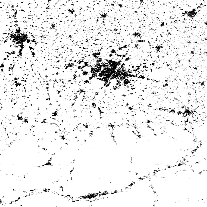
Global Urban Footprint (GUF) - TSX/TDX - Global
The Global Urban Footprint® (GUF®) dataset is based on the radar (SAR) satellite imagery of the German satellites TerraSAR-X and TanDEM-X. By creating the GUF database, scientists at the German Remote Sensing Data Center (DFD) of the German Aerospace Center (DLR) have succeeded in using a newly developed method to generate a global raster map of the world’s built-up pattern in a so far unprecedented spatial resolution of about 12m per raster cell.
Using a fully automated processing system, a global coverage of more than 180,000 very high resolution SAR images (3m ground resolution) has been analyzed acquired between 2010 and 2013. Thereby, the backscatter amplitudes of the SAR data have been used in combination with derived textural information to delineate human settlements in a highly automated, complex decision-making process. The evaluation procedure based mainly on radar signals detects the characteristic vertical structures of human habitations – primarily built-up areas. In addition, auxiliary data such as digital elevation models have been included to improve the classification process. In total, over 20 million datasets were processed with a combined volume of about 320 terabytes. The final global maps show three coverage categories (e. g. in a B/W representation): Built-up areas (vertical structures only) in black, non-built-up surfaces in white, areas of no coverage by TSX/TDX satellites (NoData) as most parts of the oceans in grey.
The final product has been optimized for fast online access through web services by merging the 5 x 5 degree GUF tiles into a single global mosaic. Furthermore reduced resolution overviews have been generated with an interpolation algorithm, that computes the average value of all contribution pixels. The global mosaic uses PackBits compression to reduce file size.
(GUF® and Global Urban Footprint® are protected as trademarks.)
Simple
- Date (Publication)
- 2016-11-18T00:00:00
- Citation identifier
- https://geoservice.dlr.de/catalogue/srv/metadata/f167eb8a-b2d3-4f86-b0aa-fb246b08dcb3
- Presentation form
- Digital map
- Status
- Completed
- Maintenance and update frequency
- Not planned
- GEMET - INSPIRE themes, version 1.0
-
-
Land cover
-
- Keywords
-
-
Land
-
urbanization
-
global mapping
-
settlement patterns
-
TerraSAR-X
-
TanDEM-X
-
SAR
-
X-Band
-
TSX-1
-
TDX-1
-
texture
-
- Access constraints
- Copyright
- Use constraints
- Other restrictions
- Other constraints
-
Nutzungsbedingungen: A non-exclusive, spatially and temporally unlimited, non-transferable, non-sublicensable right to use GUF is granted free of charge for
- scientific purposes on the high resolution version of GUF® (0.4 arcseconds),
- non-commercial purposes on the low resolution version of the GUF® (2.8 arcseconds).
This license does not grant any commercial use of GUF® or products generated or derived by GUF®.
- Use limitation
-
Nutzungseinschränkungen: GUF® is provided without any warranty. DLR is not liable for damage resulting from use.
- Spatial representation type
- Grid
- Denominator
- 24000
- Language
- English
- Character set
- UTF8
- Topic category
-
- Planning cadastre
))
- Begin date
- 2010-12-01T00:00:00
- End date
- 2013-06-30T00:00:00
- Reference system identifier
- EPSG / WGS 84 (EPSG:4326) / 7.4
- Number of dimensions
- 2
- Dimension name
- Row
- Dimension size
- 0
- Resolution
- 12 m
- Dimension name
- Column
- Dimension size
- 0
- Resolution
- 12 m
- Cell geometry
- Area
- Transformation parameter availability
- No
- Distribution format
-
- OnLine resource
- Global Urban Footprint
- OnLine resource
-
GUF04_DLR_v1_Mosaic
(
OGC:WMS-1.3.0-http-get-map
)
WMS access Global Urban Footprint (0.4 arcseconds - 12 m), for scientific use only
- OnLine resource
-
GUF28_DLR_v1_Mosaic
(
OGC:WMS-1.3.0-http-get-map
)
WMS access Global Urban Footprint (2.8 arcseconds - 84 m), for non-commercial use only
- OnLine resource
- KML Global Urban Footprint (0.4 arcseconds - 12 m) ( GLG:KML-2.0-http-get-map )
- OnLine resource
- KML Global Urban Footprint (2.8 arcseconds - 84 m) ( GLG:KML-2.0-http-get-map )
- OnLine resource
- DLR-GUF License Agreement and Order Form ( WWW:LINK-1.0-http--link )
- OnLine resource
- DLR-GUF Product Specifications ( WWW:LINK-1.0-http--link )
- OnLine resource
- GUF References ( WWW:LINK-1.0-http--link )
- Hierarchy level
- Dataset
Domain consistency
- Measure identification
- INSPIRE / Conformity_001
Conformance result
- Date (Publication)
- 2010-12-08
- Explanation
-
See the referenced specification
- Pass
- Yes
- Statement
-
The Global Urban Footprint® (GUF®) dataset is based on the radar (SAR) satellite imagery of the German satellites TerraSAR X and TanDEM X. Using a fully automated processing system, the so-called Urban Footprint Processor, a global coverage of more than 180,000 very high resolution SAR images (3m ground resolution) has been analyzed, mainly acquired between 2010 and 2013. Thereby, the backscatter amplitudes of the SAR data have been used in combination with derived textural information to delineate human settlements in a highly automated, complex decision-making process. In addition, auxiliary data such as digital elevation models have been included to improve the classification process. The data collection of satellite imagery was performed mainly between 2011 and 2012 (93 %), with single scenes with more recent acquisition dates (of 2013 / 2014) used to fill data gaps.
For more details see:
Esch, T., Marconcini, M., Felbier, A., Roth, A., Heldens, W., Huber, M., Schwinger, M., Taubenböck, H., Müller, A., Dech, S. (2013) Urban Footprint Processor – Fully Automated Processing Chain Generating Settlement Masks from Global Data of the TanDEM-X Mission. IEEE Geoscience and Remote Sensing Letters, Vol. 10, No. 6, November 2013. Pp. 1617-1621. ISSN 1545-598X, DOI 10.1109/LGRS.2013.2272953 (see: http://elib.dlr.de/83318/ )
- Description
-
All 5° x 5° tiles have been merged with GDAL (v2.1.1) into a global mosaic for fast web delivery.
- Description
-
Reduced resolution overviews have been generated with average interpolation using GDAL (v2.1.1).
- File identifier
- f167eb8a-b2d3-4f86-b0aa-fb246b08dcb3 XML
- Metadata language
- English
- Character set
- UTF8
- Hierarchy level
- Dataset
- Date stamp
- 2024-06-20T13:06:53
- Metadata standard name
-
ISO 19115:2003/19139
- Metadata standard version
-
1.0
Overviews

Spatial extent
Provided by
