 My GeoNetwork catalogue
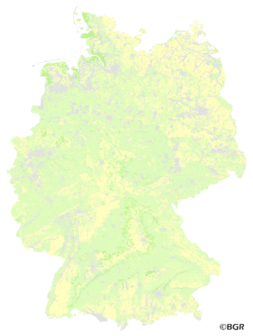
Relative binding strength of isoproturon in German topsoils
The map of the relative binding strength of isoproturon in topsoils (0-30 cm) gives an overview of the sorption of this pesticide in the soils of Germany. A high binding strength of isoproturon can reduce the harmful impact on the environment by a decreased mobility. The decomposition of isoproturon in soils was not taken into account during generation of the map. The basis for calculation of the binding strength was the soil map 1:1,000,000 (BUEK1000) as well as linking rules and tabular values of isoproturon binding from Mueller & Waldeck (2011) and Rexilius & Blume (2004). However, the rank of isoproturon binding by clay was recalculated based 175 datasets of 18 publications (shift from rank 5 to rank 1). The binding strength of isoproturon depends on the content of organic matter and the soil texture (proxy for the content of clay minerals and sesquioxides) in this evaluation.
- Identification
- Distribution
- Quality
- Spatial rep.
- Ref. system
- Content
- Portrayal
- Metadata
- Md. constraints
- Md. maintenance
- Schema info
Identification
Data identification
Citation
- Alternate title
-
FOBIP3DM1000_250
- Date (Creation)
- 2014-06-20
- Date (Publication)
- 2015-08-03
- Edition
-
Version 1.0
- Citation identifier
- 2ceb2373-e049-4ec8-a512-aa5e9548c8b2
- Status
- Completed
-
GEMET - Concepts, version 2.4
-
-
Adsorption
-
Bodenart
-
Bodenchemie
-
Bodenkarte
-
Bodenkunde
-
Bodenprozess
-
Bodenschadstoff
-
Humus
-
Organische Substanz
-
Pedosphäre
-
Pestizideinsatz
-
Sorption
-
Pflanzenschutzmittel
-
-
GEMET - INSPIRE themes, version 1.0
-
-
Boden
-
Soil
-
-
Freies Schlagwort
-
-
Sorptionsstärke
-
Relative Bindungsstärke
-
Oberboden
-
Isoproturon
-
Verknüpfungsregeln
-
FISBo BGR
-
- Place
-
-
Bundesrepublik Deutschland
-
Legal constraints
- Access constraints
- Other restrictions
- Other constraints
- Es gelten keine Zugriffsbeschränkungen
Legal constraints
- Use constraints
- Other restrictions
- Other constraints
-
Allgemeine Geschäftsbedingungen, siehe https://www.bgr.bund.de/AGB - General terms and conditions, see https://www.bgr.bund.de/AGB_en . Die bereitgestellten Informationen sind bei Weiterverwendung wie folgt zu zitieren: Datenquelle: FOBIP3DM1000_250 V1.0, (c) BGR, Hannover, 2015.
- Spatial representation type
- Grid
- Denominator
- 1000000
- Language
- Deutsch
- Character set
- UTF8
- Topic category
-
- Geoscientific information
))
- Geographic identifier
- Regionalschlüssel / 000000000000
Distribution
Distribution
- Distribution format
-
-
georef. TIFF
(
n/a
)
-
georef. TIFF
(
n/a
)
Digital transfer options
- Transfer size
- 3
- OnLine resource
-
FOBIP3DM1000_250 (georef. TIFF)
FOBIP3DM1000_250 im Format georeferenziertes TIFF
- OnLine resource
- Karte im BGR-Geoviewer
Quality
Data quality
Scope
- Hierarchy level
- Dataset
Conformance result
Citation
- Date (Publication)
- 2010-12-08
- Explanation
-
siehe dazu die angegebene Durchführungsbestimmung
- Statement
-
Bodendaten aus BÜK1000 (BGR), 175 Datensätze aus Literaturangaben. Methoden-Wiki im FISBo BGR.
Ref. system
- Unique resource identifier
- EPSG:3034
Metadata
Metadata
- File identifier
- f25c8e46-3958-4edb-89fd-9ca8a940fc8a XML
- Metadata language
- Deutsch
- Character set
- UTF8
- Hierarchy level
- Dataset
- Hierarchy level name
-
Boden
- Date stamp
- 2023-08-22
- Metadata standard name
-
INSPIRE Metadata Implementing Rules: Technical Guidelines based on EN ISO 19115 and EN ISO 19119
- Metadata standard version
-
n/a
Overviews
Spatial extent
Provided by
