 My GeoNetwork catalogue
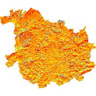
Einstrahlungsgrid - Einstrahlungsgrid St. Wendel
Der Kartendienst (WMS Gruppe) stellt Daten des Einstrahlungsgrid des Saarlandes dar.:Das Einstrahlungsgrid umfasst die Darstellung der Sonneneinstrahlung für den Landkreis St. Wendel als jährliche Einstrahlung pro m² (Einheit kWh/a) auf die Bodenfläche, ausgewiesen in Quadraten von jeweils 100 m². Das Grid kann als Hilfe zur Planung von Freiflächenphotovoltaikanlagen dienen. Ebenso kann es unterstützend in Planungsprozessen in den Bereichen Tourismus, Raumplanung, Land- und Forstwirtschaft zum Einsatz kommen.
INSPIRE
Identification
- File identifier
- f3786141-2564-0502-d3b9-3334d1a93007 XML
- Hierarchy level
- Service
Online resource
- Protocol
-
OGC:WMS-1.1.1-http-get-map
Resource identifier
Encoding
Projection
Classification of data and services
- Service Type
- view
- Coupling Type
- Tight
Coupled resource
Coupled resource
Classification of data and services
- Service Type
- view
- Coupling Type
- Tight
Coupled resource
Coupled resource
Keywords
Other keywords
- Keywords
-
-
Photovoltaik
-
Sonneneinstrahlung
-
Einstrahlungsgrid
-
infoMapAccessService
-
wetter_klima
-
Geographic coverage
))
Temporal reference
Temporal extent
Temporal extent
- Date (Revision)
- 2025-04-15
Conformity
Conformity
Conformity
Conformity
Conformity
Conformity
- Explanation
-
No explanation available
- Explanation
-
No explanation available
- Explanation
-
No explanation available
- Explanation
-
No explanation available
- Explanation
-
No explanation available
- Explanation
-
No explanation available
- Explanation
-
No explanation available
- Explanation
-
No explanation available
Restrictions on access and use
- Access constraints
- INSPIRE: Keine Beschränkungen des öffentlichen Zugangs: Es existieren keine Beschränkungen des öffentlichen Zugangs zu Daten und Diensten
- Access constraints
- Es gelten keine Bedingungen
Responsible organization (s)
Contact for the resource
- Organisation name
-
Ministerium für Umwelt, Klima, Mobilität, Agrar und Verbraucherschutz
Responsible organization (s)
Contact for the resource
- Organisation name
-
Ministerium für Umwelt, Klima, Mobilität, Agrar und Verbraucherschutz
Metadata information
Contact for the metadata
- Organisation name
-
GDI-Saarland
- Date stamp
- 2025-04-15
- Metadata language
- Deutsch
SDS
Conformance class 1: invocable
- Pass
- Yes
- Pass
- Yes
- Pass
- Yes
- Pass
- Yes
- Pass
- Yes
- Pass
- Yes
- Pass
- Yes
- Pass
- Yes
Access Point URL
Endpoint URL
Technical specification
- Date
- Explanation
-
No explanation available
- Date
- Explanation
-
No explanation available
- Date
- Explanation
-
No explanation available
- Date
- Explanation
-
No explanation available
- Date
- Explanation
-
No explanation available
- Date
- Explanation
-
No explanation available
- Date
- Explanation
-
No explanation available
- Date
- Explanation
-
No explanation available
Conformance class 2: interoperable
Access constraints
- Access constraints
- Other restrictions
- Other constraints
- INSPIRE: Keine Beschränkungen des öffentlichen Zugangs: Es existieren keine Beschränkungen des öffentlichen Zugangs zu Daten und Diensten
Limitation
Use constraints
- Use constraints
- Other restrictions
- Other constraints
- Es gelten keine Bedingungen
Limitation
Responsible custodian
Contact for the resource
Conformance class 3: harmonized
Contains Operations
- Operation Name
-
GetCapabilities
- Distributed Computing Platforms
- Web services
Overviews
Spatial extent
Provided by
