 My GeoNetwork catalogue
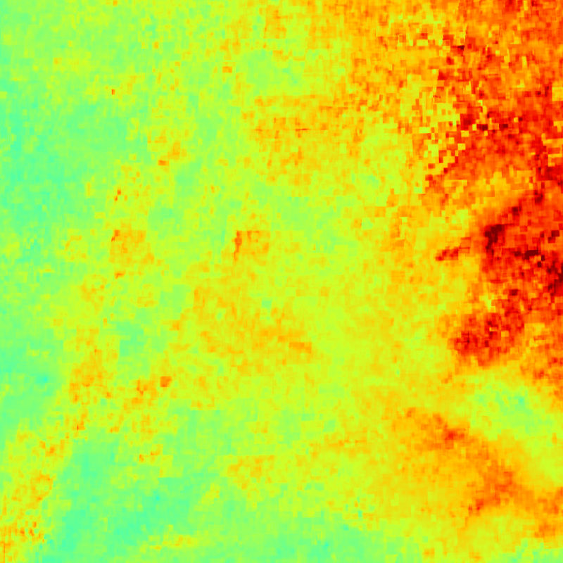
S-VELD - MODIS/SLSTR Surface PM2.5 - Germany, Monthly
This collection contains monthly mean surface PM2.5 concentrations for Germany and parts of the surrounding countries. PM2.5 surface concentrations are derived from Aqua/MODIS and Sentinel-3A/SLSTR AOD data and provided as merged MODIS/SLSTR product. The data is generated by DLR and provided in the framework of the mFUND-Project "S-VELD". The surface PM2.5 data are concentrations with the unit "µg/m3". The satellites Aqua (NASA) and Sentinel-3 (Copernicus) observe Germany on a daily basis. PM2.5 concentrations were derived on a daily basis from the two AOD products separately and combined to a merged MODIS/SLSR surface PM2.5 product. The data within each month are averaged and gridded onto a regular UTM grid. As AOD measurements are strongly depending on cloud conditions, the spatial coverage can be limited, especially in the winter months.
- Identification
- Distribution
- Quality
- Spatial rep.
- Ref. system
- Content
- Portrayal
- Metadata
- Md. constraints
- Md. maintenance
- Schema info
Identification
Data identification
Citation
- Date (Creation)
- 2021-02-11T10:48:00
- Citation identifier
- https://geoservice.dlr.de/catalogue/srv/metadata/f4adec97-78c7-4639-845f-b8de13347c31
- Presentation form
- Digital map
- Status
- Completed
- Maintenance and update frequency
- As needed
- Keywords
-
-
AQUA
-
MODIS
-
Sentinel-3A
-
SLSTR
-
Germany
-
S-VELD
-
PM2.5
-
particulate matter
-
aerosol
-
air quality
-
monthly
-
opendata
-
mFUND-FKZ: 19F2065A
-
mFUND-Projekt: S-VELD
-
mCLOUD
-
mcloud_category_roads
-
mcloud_category_aviation
-
- Use limitation
-
Nutzungseinschränkungen: Das DLR ist nicht haftbar für Schäden, die sich aus der Nutzung ergeben. / Use Limitations: DLR not liable for damage resulting from use.
- Use limitation
-
Nutzungsbedingungen: Lizenz, https://creativecommons.org/licenses/by-nc/4.0 / Terms of use: License, https://creativecommons.org/licenses/by-nc/4.0
Legal constraints
- Access constraints
- Other restrictions
- Other constraints
-
License
Legal constraints
- Use constraints
- Other restrictions
- Other constraints
-
{"id": "cc-by-nc/4.0",
"name": "Creative Commons Namensnennung - Nicht kommerziell 4.0 International (CC BY-NC 4.0)",
"url": " http://dcat-ap.de/def/licenses/cc-by-nc/4.0 ",
"quelle": "Primary and Altered Products: Copernicus data (year of reception); Derivative Works: contains Copernicus data (year of reception); Copyright DLR (year of production)"}
- Spatial representation type
- Grid
- Denominator
- 1000000
- Language
- English
- Character set
- UTF8
- Topic category
-
- Climatology, meteorology, atmosphere
Extent
))
- Begin date
- 2018-01-01T00:00:00
- End date
- 2019-12-31T00:00:00
Distribution
Distribution
- Distribution format
-
-
WMS
(
1.1.1 1.3.0
)
-
Dateidownload
(
)
-
Portal
(
)
-
WMS
(
1.1.1 1.3.0
)
Digital transfer options
- OnLine resource
-
SVELD_MODIS_SLSTR_PM25SURF_P1M
(
OGC:WMS
)
S-VELD MODIS/SLSTR Surf. PM2.5 - Monthly
- OnLine resource
-
HTTP Download
(
WWW:LINK-1.0-http--link
)
HTTP Download (S-VELD MODIS/SLSTR Surf. PM2.5)
- OnLine resource
-
EOC Geoservice Map Context
(
WWW:LINK-1.0-http--link
)
EOC Geoservice Map Context (de:sveld:pm25surf:monthly)
- OnLine resource
- S-VELD mFUND Project Description (German) ( WWW:LINK-1.0-http--link )
- OnLine resource
- S-VELD DLR Project Website (German) ( WWW:LINK-1.0-http--link )
Quality
Data quality
- Hierarchy level
- Series
Domain consistency
- Measure identification
- INSPIRE / Conformity_001
Conformance result
Citation
- Date (Publication)
- 2010-12-08
- Explanation
-
See the referenced specification.
- Pass
- Yes
Lineage
- Statement
-
Input data: AQUA MODIS, Sentinel-3A SLSTR AOD Copernicus data provided by Swansea university
- Description
-
Please refer to the product user manual for a description of the processing steps: https://atmos.eoc.dlr.de/sveld/doc/TBD
Spatial rep.
Grid spatial representation
- Number of dimensions
- 2
Dimension
- Dimension name
- Column
- Dimension size
- 2200
- Resolution
- 500 m
Dimension
- Dimension name
- Row
- Dimension size
- 2320
- Resolution
- 500 m
- Cell geometry
- Area
- Transformation parameter availability
- No
Ref. system
- Unique resource identifier
- EPSG:25832
Metadata
Metadata
- File identifier
- f4adec97-78c7-4639-845f-b8de13347c31 XML
- Metadata language
- English
- Character set
- UTF8
- Hierarchy level
- Series
- Hierarchy level name
-
Dataseries
- Date stamp
- 2024-06-20T13:07:24
- Metadata standard name
-
19115-1:2014/19139
- Metadata standard version
-
1.0
Overviews
Spatial extent
Provided by
