 My GeoNetwork catalogue
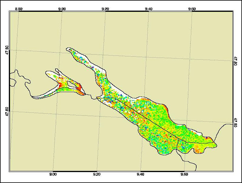
MERIS - Water Parameters - Lake Constance, 10-Day
The Medium Resolution Imaging Spectrometer (MERIS) on Board ESA’s ENVISAT provides spectral high resolution image data in the visible-near infrared spectral region (412-900 nm) at a spatial resolution of 300 m. For more details on ENVISAT and MERIS see http://envisat.esa.int/
This product developed in the frame of the MAPP project (MERIS Application and Regional Products Projects) represents the chlorophyll concentration of Lake Constance derived from MERIS data. The product is a cooperative effort of DLR-DFD and the Institute for Coastal Research at the GKSS Research Centre Geesthacht. DFD pre-processed up to the value added level whenever MERIS data for the North Sea region was received and positively checked for a water area large enough for a suitable interpretation.
For more details the reader is referred to
http://wdc.dlr.de/sensors/meris/ and http://wdc.dlr.de/sensors/meris/documents/Mapp_ATBD_final_i3r0dez2001.pdf
This product provides 10-days maps.
- Identification
- Distribution
- Quality
- Spatial rep.
- Ref. system
- Content
- Portrayal
- Metadata
- Md. constraints
- Md. maintenance
- Schema info
Identification
Data identification
Citation
- Date (Creation)
- 2015-08-01T00:00:00
- Citation identifier
- https://geoservice.dlr.de/catalogue/srv/metadata/f97068fa-c098-4521-87ec-357c6e3b6960
- Presentation form
- Digital map
- Status
- Completed
- Maintenance and update frequency
- Not planned
-
GEMET - INSPIRE themes, version 1.0
-
-
Sea regions
-
- Keywords
-
-
ENVISAT
-
MERIS
-
Lake Constance
-
Water parameter
-
10-days
-
urn:eop:DLR:EOWEB:Water_Parameter_Lake_Constance_MERIS_10-days_maps
-
FEDEO
-
Legal constraints
- Access constraints
- License
- Use constraints
- Other restrictions
- Other constraints
-
Nutzungsbedingungen: CC BY-SA 'Attribution ShareAlike' https://creativecommons.org/licenses/by-sa/4.0/legalcode
Reference for the use of MERIS products in publications: Products generated by DLR-DFD
- Use limitation
-
Nutzungseinschränkungen: DLR not liable for damage resulting from use
- Spatial representation type
- Grid
- Denominator
- 600000
- Language
- English
- Character set
- UTF8
- Topic category
-
- Inland waters
Extent
))
- Begin date
- 2006-01-01T08:00:16
- End date
- 2010-03-10T12:09:12
Distribution
Distribution
- Distribution format
-
- OnLine resource
-
MERIS - Water Parameters - Lake Constance, 10-Day
(
WWW:LINK-1.0-http--link
)
EOWEB GeoPortal Collection
Quality
Data quality
- Hierarchy level
- Series
Domain consistency
- Measure identification
- INSPIRE / Conformity_001
Conformance result
Citation
- Date (Publication)
- 2010-12-08
- Explanation
-
See the referenced specification
- Pass
- Yes
Lineage
- Statement
-
For further information see: http://wdc.dlr.de/sensors/meris/ and http://wdc.dlr.de/sensors/meris/documents/Mapp_ATBD_final_i3r0dez2001.pdf
Ref. system
- Reference system identifier
- EPSG / ETRS89 / LAEA Europe (EPSG:3035) / 8.6
Metadata
Metadata
- File identifier
- f97068fa-c098-4521-87ec-357c6e3b6960 XML
- Metadata language
- English
- Character set
- UTF8
- Hierarchy level
- Series
- Hierarchy level name
-
Dataseries
- Date stamp
- 2024-09-27T13:20:39
- Metadata standard name
-
ISO 19115-1:2014/19139
- Metadata standard version
-
1.0
Overviews
Spatial extent
Provided by
