 My GeoNetwork catalogue
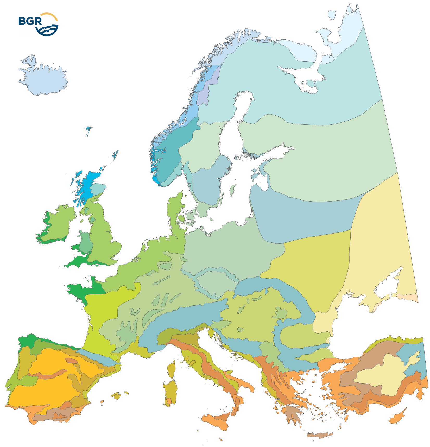
Climatic Areas of Europe 1:15,000,000
The Climatic Areas of Europe (EUCA15000) were delineated in order to stratify the legend of the European Soil Regions Map (EUSR5000). Because soil properties largely depend on climate, relief and geology, soil regions must be defined according to fairly homogenous macro-scale physiogeographic conditions. Because climate (and parent material) is the initial top level stratifier for the soil regions, its delineation is more coarsely defined. The EUCA15000 is mainly based on the Thermal Climate Classification (FAO 2004), which also has been used as a data source for the Global Agro-Ecological Zones (AEZ). Currently, the map distinguishes (i) the climate zones from North to South and (ii) the climate types with oceanic to continental influence. All in all, 35 climatic areas are delineated. They differ regarding mean annual temperatures, mean annual precipitation and the length of the growing period.
Simple
- Alternate title
-
EUCA15000
- Date (Publication)
- 2025-09-04
- Date (Creation)
- 2005-08-09
- Edition
-
1.0
- Citation identifier
- 48cc976c-ac43-57f8-be08-df324ee4d2f7
- Citation identifier
- https://doi.org/10.25928/EUCA15000_1.0
- Status
- Completed
-
GEMET - INSPIRE themes, version 1.0
-
-
Atmospheric conditions
-
- Theme
-
-
Climate
-
Klima
-
Climate zones
-
Klimazonen
-
Klimaregionen
-
Climate types
-
Klimatypen
-
Atmospheric precipitation
-
Mittlerer Jahresniederschlag
-
Atmospheric temperature
-
European Union
-
Europäische Union
-
- Place
-
-
Europa
-
Europe
-
- Access constraints
- Other restrictions
- Other constraints
- Es gelten keine Zugriffsbeschränkungen
- Use constraints
- Other restrictions
- Other constraints
-
General Standard Terms and Conditions (GSTC) of the Federal Institute for Geosciences and Natural Resources (BGR). The LBEG or the BGR is the owner of the rights of exploitation for software, digital data, and other products protected by copyright, as well as know-how. The contractual partner receives a simple right of use for the types of use defined in the following. The right to duplicate and present is also transferred. The rights which are not transferred include in particular the right to make accessible to the public, unless the contractual partner makes the aforementioned accessible to the public within the framework of an administrative procedure when acting as a participating authority in said administrative procedure. For the purpose of reuse the provided information has to be quoted as follows: BGR [Bundesanstalt für Geowissenschaften und Rohstoffe] (2005). Soil Regions Map of the European Union and Adjacent Countries 1:5,000,000 (Version 2.0). Special Publication, Ispra. EU catalogue number S.P.I.05.134.
- Spatial representation type
- Vector
- Denominator
- 15000000
- Language
- English
- Character set
- UTF8
- Topic category
-
- Geoscientific information
))
- Unique resource identifier
- EPSG:3035
- Distribution format
-
-
PDF
(
n/a
)
-
Shapefile
(
n/a
)
-
GeoPackage
(
n/a
)
-
PDF
(
n/a
)
- OnLine resource
-
EUCA15000 (PDF)
EUCA15000 im Format Adobe Acrobat Datei
- OnLine resource
-
EUCA15000 (Shapefile)
EUCA15000 im Format ESRI Shape
- OnLine resource
-
EUCA15000 (GeoPackage)
EUCA15000 im Format GeoPackage
- Hierarchy level
- Dataset
- Statement
-
Die Datenquellen sind in Hartwich et al. (2005) gelistet und erläutert: - Europaweite thematische Karten und Datensätze - Nationale/regionale Bodenkarten und Expertenwissen von Mitgliedern des European Soil Bureau Network (ESBN) - The data sources are listed, explained and cited in Hartwich et al. (2005): - Europe-wide thematic maps and data sets - national/regional soil maps and expert knowledge from members of the European Soil Bureau Network (ESBN)
- File identifier
- fb02933b-43e3-4bcf-a663-cfb16a7cf926 XML
- Metadata language
- English
- Character set
- UTF8
- Hierarchy level
- Dataset
- Hierarchy level name
-
Boden
- Date stamp
- 2025-09-11
- Metadata standard name
-
INSPIRE Metadata Implementing Rules: Technical Guidelines based on EN ISO 19115 and EN ISO 19119
- Metadata standard version
-
n/a
Overviews
Spatial extent
Provided by
