 My GeoNetwork catalogue
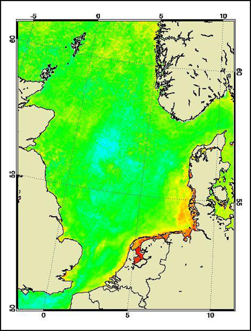
MERIS - Water Parameters - North Sea, Monthly
The Medium Resolution Imaging Spectrometer (MERIS) on Board ESA’s ENVISAT provides spectral high resolution image data in the visible-near infrared spectral region (412-900 nm) at a spatial resolution of 300 m. For more details on ENVISAT and MERIS see http://envisat.esa.int/
This product developed in the frame of the MAPP project (MERIS Application and Regional Products Projects) represents the chlorophyll concentration of the North Sea derived from MERIS data. The product is a cooperative effort of DLR-DFD and the Institute for Coastal Research at the GKSS Research Centre Geesthacht. DFD pre-processed up to the value added level whenever MERIS data for the North Sea region was received and positively checked for a water area large enough for a suitable interpretation.
For more details the reader is referred to
http://wdc.dlr.de/sensors/meris/ and http://wdc.dlr.de/sensors/meris/documents/Mapp_ATBD_final_i3r0dez2001.pdf
This product provides monthly maps.
Simple
- Date (Creation)
- 2015-08-01T00:00:00
- Citation identifier
- https://geoservice.dlr.de/catalogue/srv/metadata/fb086eaa-fbce-4a4e-a7f8-7184ecdbafe7
- Presentation form
- Digital map
- Status
- Completed
- Maintenance and update frequency
- Not planned
-
GEMET - INSPIRE themes, version 1.0
-
-
Oceanographic geographical features
-
- Keywords
-
-
ENVISAT
-
MERIS
-
North Sea
-
Water parameter
-
monthly
-
urn:eop:DLR:EOWEB:Water_Parameter_North_Sea_MERIS_monthly_maps
-
FEDEO
-
- Access constraints
- License
- Use constraints
- Other restrictions
- Other constraints
-
Nutzungsbedingungen: CC BY-SA 'Attribution ShareAlike' https://creativecommons.org/licenses/by-sa/4.0/legalcode
Reference for the use of MERIS products in publications: Products generated by DLR-DFD
- Use limitation
-
Nutzungseinschränkungen: DLR not liable for damage resulting from use
- Spatial representation type
- Grid
- Denominator
- 600000
- Language
- English
- Character set
- UTF8
- Topic category
-
- Oceans
))
- Begin date
- 2006-01-01T08:00:16
- End date
- 2010-02-28T12:22:31
- Reference system identifier
- EPSG / ETRS89 / LAEA Europe (EPSG:3035) / 8.6
- Distribution format
-
- OnLine resource
-
MERIS - Water Parameters - North Sea, Monthly
(
WWW:LINK-1.0-http--link
)
EOWEB GeoPortal Collection
- Hierarchy level
- Series
Domain consistency
- Measure identification
- INSPIRE / Conformity_001
Conformance result
- Date (Publication)
- 2010-12-08
- Explanation
-
See the referenced specification
- Pass
- Yes
- Statement
-
For further information see: http://wdc.dlr.de/sensors/meris/ and http://wdc.dlr.de/sensors/meris/documents/Mapp_ATBD_final_i3r0dez2001.pdf
- File identifier
- fb086eaa-fbce-4a4e-a7f8-7184ecdbafe7 XML
- Metadata language
- English
- Character set
- UTF8
- Hierarchy level
- Series
- Hierarchy level name
-
Dataseries
- Date stamp
- 2024-09-27T14:07:04
- Metadata standard name
-
ISO 19115-1:2014/19139
- Metadata standard version
-
1.0
Overviews

Spatial extent
Provided by
