 My GeoNetwork catalogue
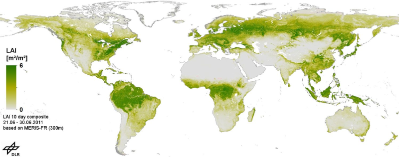
MERIS - Gap Free Leaf Area Index (LAI) - Global
This product consists of global gap free Leaf area index (LAI) time series, based on MERIS full resolution Level 1B data. It is produced as a series of 10-day composites in geographic projection at 300m spatial resolution. The processing chain comprises geometric correction, radiometric correction and pixel identification, LAI calculation with the BEAM MERIS vegetation processor, re-projection to a global grid, and temporal aggregation selecting the measurement closest to the mean value. After the LAI pre-processing we applied time series analysis to fill data gaps and filter outliers using the technique of harmonic analysis in combination with mean annual and multiannual phenological data. Data gaps are caused by clouds, sensor limitations due to the solar zenith angle (less than 10 degrees), topography and intermittent data reception. We applied our technique for the whole period of observation (Jul 2002 - Mar 2012). Validation, was performed using VALERI and BigFoot data.
INSPIRE
Identification
- File identifier
- fb4b4be0-a4a3-4dcd-b381-bacde381d3eb XML
- Hierarchy level
- Dataset
Online resource
Resource identifier
- Metadata language
-
eng
- Spatial representation type
- Grid
Encoding
- Format
-
GeoTIFF
Projection
Classification of data and services
- Topic category
-
- Biota
Classification of data and services
Coupled resource
Coupled resource
Classification of data and services
Coupled resource
Coupled resource
Keywords
-
GEMET - INSPIRE themes, version 1.0
-
-
Land cover
-
Other keywords
- Keywords
-
-
ENVISAT
-
MERIS
-
LAI
-
Time series analysis
-
urn:eop:DLR:EOWEB:MERIS-FR-LAI-HA
-
FEDEO
-
Geographic coverage
))
Temporal reference
Temporal extent
- Begin
- 2003-01-01T00:00:00
- End
- 2011-01-31T23:59:00
Temporal extent
- Date (Creation)
- 2015-01-05T00:00:00
Quality and validity
- Lineage
-
MERIS-FR Level 1b
- Denominator
- 600000
Conformity
Conformity
Conformity
Conformity
Conformity
Conformity
- Explanation
-
See the referenced specification
Restrictions on access and use
- Access constraints
- There are no limitations on public access to spatial data sets and services.
- Access constraints
-
Nutzungsbedingungen: Lizenz / Terms of Use: https://geoservice.dlr.de/resources/licenses/D-SDA_DataLicenseTerms.pdf
Responsible organization (s)
Contact for the resource
- Organisation name
-
German Aerospace Center (DLR)
- Organisation name
-
German Aerospace Center (DLR)
Responsible organization (s)
Contact for the resource
- Organisation name
-
German Aerospace Center (DLR)
- Organisation name
-
German Aerospace Center (DLR)
Metadata information
Contact for the metadata
- Organisation name
-
German Aerospace Center (DLR)
- Date stamp
- 2024-06-20T14:12:22
- Metadata language
- English
- Character set
- UTF8
SDS
Conformance class 1: invocable
Access Point URL
Endpoint URL
Technical specification
Conformance class 2: interoperable
Access constraints
Limitation
Use constraints
Limitation
Responsible custodian
Contact for the resource
Overviews

Spatial extent
Provided by
