 My GeoNetwork catalogue
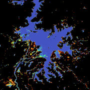
Global WaterPack - MODIS - Monthly
The Global WaterPack is a dataset containing information about open surface water cover parameters on a global scale. The water detection is derived from daily, operational MODIS datasets for every year since 2003. The negative effects of polar darkness and cloud coverage are compensated by applying interpolation processing steps. Thereby, a unique global dataset can be provided that is characterized by its high temporal resolution of one day and a spatial resolution of 250 meter. This collection includes monthly composites of the dataset with information on how often a pixel was detected as open surface water with pixel values between 0 and 31. Furthermore, a reliability layer provides information on the quality of each Global WaterPack pixel.
Simple
- Date (Creation)
- 2023-08-01T09:48:00
- Citation identifier
- https://geoservice.dlr.de/catalogue/srv/metadata/fd2b6905-1890-4b4b-99be-a481641261fe
- Presentation form
- Digital map
- Other citation details
-
DOI: 10.15489/i563nkgncc13
- Status
- Completed
- Maintenance and update frequency
- As needed
- GEMET - INSPIRE themes, version 1.0
-
-
Land cover
-
Hydrography
-
- Keywords
-
-
MODIS
-
Terra
-
Aqua
-
Global
-
water bodies
-
water dynamics
-
water extent
-
opendata
-
- Use limitation
-
Nutzungseinschränkungen: Das DLR ist nicht haftbar für Schäden, die sich aus der Nutzung ergeben. / Use Limitations: DLR not liable for damage resulting from use.
- Access constraints
- Other restrictions
- Other constraints
- Es gelten keine Zugriffsbeschränkungen
- Use constraints
- Other restrictions
- Other constraints
-
Nutzungsbedingungen: Lizenz, https://creativecommons.org/licenses/by/4.0 / Terms of use: License, https://creativecommons.org/licenses/by/4.0
- Other constraints
-
{"id": "cc-by-4.0",
"name": "Creative Commons Namensnennung – 4.0 International (CC BY 4.0)",
"url": " http://dcat-ap.de/def/licenses/cc-by/4.0 ",
"quelle": "Copyright DLR (year of production)"}
- Spatial representation type
- Grid
- Denominator
- 500000
- Language
- English
- Character set
- UTF8
- Topic category
-
- Imagery base maps earth cover
- Inland waters
))
- Begin date
- 2003-01-01T00:00:00
- End date
- 2022-12-31T23:59:59
- Unique resource identifier
- EPSG:4326
- Number of dimensions
- 2
- Dimension name
- Column
- Dimension size
- 172800
- Resolution
- 250 m
- Dimension name
- Row
- Dimension size
- 86400
- Resolution
- 250 m
- Cell geometry
- Area
- Transformation parameter availability
- No
- Distribution format
-
-
GeoTIFF
()
-
GeoTIFF
()
- OnLine resource
-
Global WaterPack (GWP) DLR information page
(
WWW:LINK-1.0-http--link
)
Webpage with additional information on the Global WaterPack (GWP)
- OnLine resource
-
EOC Geoservice Map Context
(
WWW:LINK-1.0-http--link
)
EOC Geoservice Map Context (eoc:gwp:monthly)
- OnLine resource
-
GWP_P1M
(
OGC:WMS
)
Global WaterPack Monthly
- OnLine resource
-
GWP_REL_P1M
(
OGC:WMS
)
Global WaterPack Monthly - Reliability
- OnLine resource
- https://geoservice.dlr.de/eoc/land/wms?SERVICE=WMS&REQUEST=GetCapabilities ( OGC:WMS-http-get-capabilities )
- OnLine resource
-
HTTP Download
(
WWW:LINK-1.0-http--link
)
HTTP Download (GlobalWaterPack - Monthly)
- Hierarchy level
- Dataset
Domain consistency
- Measure identification
- INSPIRE / Conformity_001
Conformance result
- Date (Publication)
- 2010-12-08
- Explanation
-
See the referenced specification.
- Pass
- Yes
- Statement
-
The main input datasets are daily MODIS products MOD09GQ and MYD09GQ at 250m and MOD10A1 and MYD10A1 at 500m spatial resolution. Additional auxiliary datasets, such as DEM, MOD44W and the ESA-CCI Water Bodies Map v4.0 are included within the pre- and postprocessing. For more information please refer to Klein et al. 2017.
- Description
-
The main classification step is based on an automatic dynamic thresholding based daily data input. In a second step, a temporal interpolation is performed for all pixels which were covered by clouds or had low quality. For more information please refer to Klein et al. 2017.
- File identifier
- fd2b6905-1890-4b4b-99be-a481641261fe XML
- Metadata language
- English
- Character set
- UTF8
- Hierarchy level
- Dataset
- Hierarchy level name
-
Dataset
- Date stamp
- 2024-11-13T13:41:16
- Metadata standard name
-
ISO19115
- Metadata standard version
-
2003/Cor.1:2006
Overviews

Spatial extent
Provided by
