 My GeoNetwork catalogue
Provided by
Type of resources
Available actions
Topics
Keywords
Contact for the resource
Update frequencies
Service types
-

This service contains information on the population density of 16 seabird species and 3 seabird groups in the German Exclusive Economic Zone (EEZ) based on a 10x10 km grid (EU-GRID). The density [individuals/km²] is determined for each 10x10 km grid cell by summing the number of individuals within the respective grid cell and dividing it by the sum of the sampling effort (surveyed area and period in which the area was sampled). Individual layers show the distribution of the seabird species in the respective year and for artspecific season, broken down by seabird species and season (March - May: spring; June - August: summer; September - November: autumn; December - February: winter). Direct comparability with the data in the BfN service "Seabird Monitoring Distribution" is limited, since this BSH service only uses data collected using digital flight observation technology.
-

Measurement data of size distribution of aerosols from ship exhaustgas plumes accorded with the FMPS (company TSI) on the mesurementsite Wedel
-
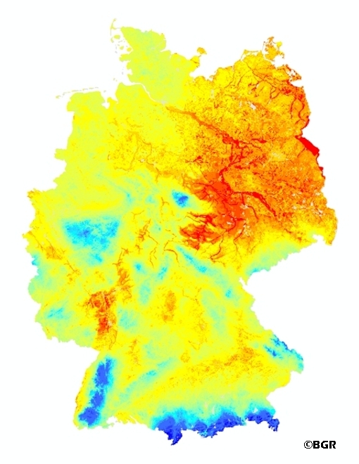
Web Map Service (WMS) of the mean annual rate of percolation from the soil in Germany (SWR1000). The mean annual rate of percolation from the soil is defined as the amount of water that leaves the soil after consideration of capillary rise. It is expressed in mm/a. Precipitation water infiltrated into the soil after deduction of surface runoff, first stands for the water supply of the vegetation available. Exceeds the water content in the root zone, the field capacity, the water infiltrated force of gravity moved following down and leaves the root zone. Movement of water in the unsaturated zone is affected by infiltration of precipitation and irrigation water, evaporation, absorption of water by plant roots, and ascent of water from the groundwater table by capillary action. The percolating water leaves the soil as interflow, discharging into surface water bodies, or via the groundwater table, recharging the groundwater. Percolating water affects soil formation and the migration and leaching of plant nutrients and contaminants. Knowledge of the rate of percolation is of particular importance for protecting groundwater quality. The mean annual rate of percolation is the balance of precipitation, evapotranspiration and surface runoff.
-

Measurement data of airpollutants (CO2, NO, NO2, NOx, O3, SO2) from ship exhaustgas plumes accorded with the AIRPOINTER (company mlu/jct) on the mesurementsite Wedel
-

The data covers the calculated yields of wind farms in German territory and the German exclusive economic zone (EEZ) and the relevant wind conditions under the assumption of an expansion of offshore wind energy defined in different scenarios. The calculations were carried out with the numerical weather model WRF using a parameterization of wind farms according to Fitch. The data are available in 10-minute temporal and 2 km x 2 km spatial resolution for the North Sea for the meteorological year 2006. The variables of the data set are wind speed (WS) and wind direction (WD) at 9 height levels between 50 m and 350 m, the power (POWER) of the wind turbines from each grid cell and the air density. A detailed description of the variables can be found in the files.
-
BGR conducted an airborne survey in the region of the Stassfurt-Egeln salt anticline as part of a BMBF research project "Dynamic processes in flooded or abandoned salt mines and their overburden”. The survey area Stassfurt (2007) is bounded by the towns and settlements Aschersleben, Kroppenstedt, Hadmersleben, Altenweddingen, Atzendorf, Förderstedt and Bernburg. The size of the area is about 467 km². The area was surveyed with 29 flights totalling 5034 line-km (132,390 survey points). The nominal separation of the 155 SE-NW lines and 33 NE-SW tie lines was 100 m and 1000 m, respectively. The maps display the total count, the (equivalent) content of potassium, uranium and thorium as well as the exposure rate at ground.
-

Layer thickness of the operational circulation model of the Federal Maritime and Hydrographic Agency of Germany (BSH), in the German Bight and the western Baltic Sea (horizontal resolution ca. 900 m). The model (HBM, HIROMB-BOOS-Model) is run four times each day in a configuration with a fine grid in the German Bight and western Baltic Sea (900 m resolution, this dataset) and a coarser grid which covers the North and Baltic Sea (5 km resolution, separate dataset). The model is forced by the weather forecast of the German Weather Service (DWD). More detailed information about the model configuration can be found in Brüning et al. (2021); https://doi.org/10.23784/HN118-01. For more information, please visit: https://gdi.bsh.de/en/data/Layer-thickness-of-the-operational-circulation-model-of-BSH-in-the-German-Bight-and-the-western-Baltic-Sea-horizontal-resolution-ca-900-m-2022_FactSheet_HBMnoku_english.pdf https://gdi.bsh.de/en/data/Layer-thickness-of-the-operational-circulation-model-of-BSH-in-the-German-Bight-and-the-western-Baltic-Sea-horizontal-resolution-ca-900-m-2022_FactSheet_HBMnoku_deutsch.pdf
-
Measurement data of air pollutants for ship emission measurements on the mesurementsite Kiel 2018 09

Measurement data of airpollutants (CO2, NO, NO2, NOx, O3, SO2) from shipexhaustgasplumes accorded with the AIRPOINTER (company mlu/jct) on the mesurementsite Kiel
-

Measurement data of airpollutants (CO2, NO, NO2, NOx, O3, SO2) from shipexhaustgasplumes accorded with the AIRPOINTER (company mlu/jct) on the ship VWFS ATAIR
-

Measurement data of airpollutants (CO2, NO, NO2, NOx, O3, SO2) from shipexhaustgasplumes accorded with the AIRPOINTER (company mlu/jct) on the ship VWFS ATAIR