 My GeoNetwork catalogue
hük250
Provided by
Type of resources
Available actions
Topics
Keywords
Contact for the resource
Service types
-
The HÜK250 (INSPIRE) describes the hydrogeological characteristics of the upper continuous aquifers in Germany at a scale of 1:250,000. According to the Data Specification on Geology (D2.8.II.4_v3.0) the map provides INSPIRE-compliant data. The hydrogeologic units are represented graphically – mostly according to the INSPIRE portrayal rules – by GE.Aquifer.MediaType, GE.Aquifer.HydrogeochemicalRockType, GE.Aquifer.permeabilityCoefficient (BGR colours), GE.Aquitard.approximatePermeabilityCoefficient (BGR colours), GE.Aquitard and GE.Aquiclude.ConstitutionOfAquiclude. The geologic units are represented graphically – according to the INSPIRE portrayal rules – by GE.GeologicUnit.AgeOfRocks and GE.GeologicUnit.Lithology. The HÜK250 is a joint project of the SGD under the leadership of the BGR.
-
The HÜK250 (INSPIRE) describes the hydrogeological characteristics of the upper continuous aquifers in Germany at a scale of 1:250,000. According to the Data Specification on Geology (D2.8.II.4_v3.0) the content of the map is stored in a INSPIRE-compliant GML file: HUEK250.gml. The GML file together with a Readme.txt file is provided in ZIP format. The Readme.txt file (German/English) contains detailed information on the GML file content. Data transformation was proceeded by using the INSPIRE Solution Pack for FME according to the INSPIRE requirements.
-
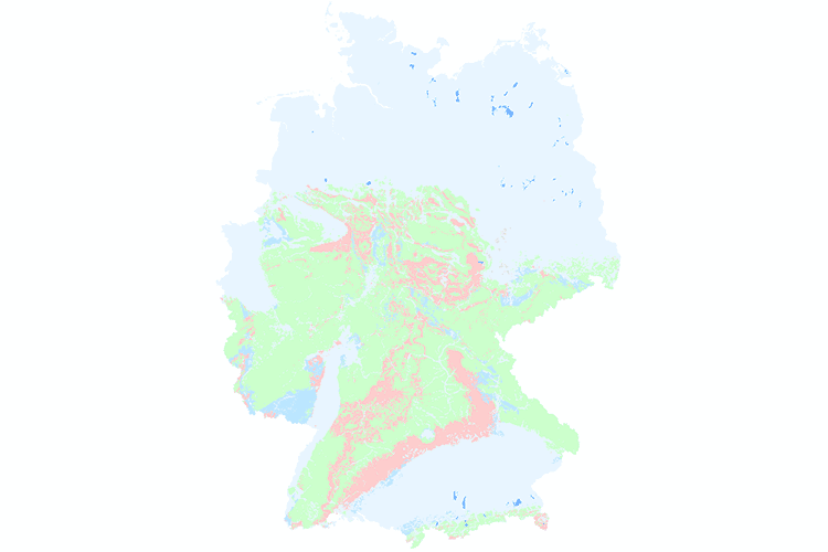
In order to support the implementation of the European Water Framework Directive (EU-WFD), the German State Geological Surveys (SGD) and the Federal Institute for Geosciences and Natural Resources (BGR) agreed in 2000 to compile a digital hydrogeological map at the scale of 1:200,000 (HÜK200), providing a harmonised survey of the upper groundwater bodies in Germany. The HÜK200 captures hydrogeologically relevant attributes such as consolidation, type of porosity, permeability, type of rock and geochemical classification to describe the hydrogeological characteristics of the rocks of the uppermost aquifers. The geological information on lithology, stratigraphy and genesis of the geological map of Germany 1:200,000 (GÜK200) provided the basic data. This information was evaluated and hydrogeologically interpreted by regional experts of the SGD or replaced and completed by other regional geological and hydrogeological maps and data where necessary. 2019, HÜK200 was migrated to a scale of 1:250.000 (now HÜK250).
-
In order to support the implementation of the European Water Framework Directive (EU-WFD), the German State Geological Surveys (SGD) and the Federal Institute for Geosciences and Natural Resources (BGR) agreed in 2000 to compile a digital hydrogeological map at the scale of 1:200,000 (HÜK200), providing a harmonised survey of the upper groundwater bodies in Germany. The HÜK200 captures hydrogeologically relevant attributes such as consolidation, type of porosity, permeability, type of rock and geochemical classification to describe the hydrogeological characteristics of the rocks of the uppermost aquifers. The geological information on lithology, stratigraphy and genesis of the geological map of Germany 1:200,000 (GÜK200) provided the basic data. This information was evaluated and hydrogeologically interpreted by regional experts of the SGD or replaced and completed by other regional geological and hydrogeological maps and data where necessary. 2019, HÜK200 was migrated to a scale of 1:250.000 (now HÜK250).