 My GeoNetwork catalogue
minerals
Provided by
Type of resources
Keywords
Contact for the resource
-
Sentinel-3 OLCI images processed with the Atmospheric Correction for Optical Water Types, A4O [Hieronymi et al. in prep & 2023], and the water algorithm OLCI Neural Network Swarm, ONNS [Hieronymi et al., 2017]. ONNS derives inherent optical properties (IOPs) from which the concentrations of water constituents are estimated. In addition, the results of an Optical Water Type (OWT) classification based on A4O reflectances are provided [Bi and Hieronymi, 2024]. All available satellite data of a day for the region of interest are merged in a common grid at approximately original resolution. Information about the variables are given in the attached Additional Info. Version 2 of the data has the license and some metadata corrected. Please use and refer only to Version 2 (see link below).
-
Satellite remote sensing enables global monitoring of water quality in freshwater and marine ecosystems. However, consistent data quality is a challenge due to variations in the performance of used algorithms for different waters. In this exemplary dataset, we use a novel approach for atmospheric correction and retrieval for water quality characteristics in inland waters, coastal areas, and the open sea. Copernicus Sentinel-3 OLCI satellite images are processed with the Atmospheric Correction for Optical Water Types, A4O [Hieronymi et al. in prep & 2023], and the water algorithm OLCI Neural Network Swarm, ONNS [Hieronymi et al., 2017]. ONNS derives inherent optical properties (IOPs) from which the concentrations of water constituents are estimated. In addition, the results of an Optical Water Type (OWT) classification based on A4O reflectances are provided [Bi and Hieronymi, 2024]. All available satellite data of a day for the region of interest are merged in a common grid at approximately original resolution. An overview of the variables in the dataset can be found in the Additional Information; a detailed description of the contents and background, as well as an optical analysis of the waters, can be found in Hieronymi et al. [2025]. Version 2 of the dataset has the license and some metadata corrected. Data itself remains unchanged.
-
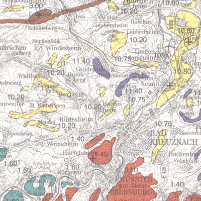
In order to exploit mineral raw materials close to the Earth's surface, experts are working on trans-regional and national planning documents. To do this, they need maps which clearly depict the raw materials close to the surface in Germany. KOR200 displays Germany's national raw material potential in a comparable way, thus forming a basis for future exploration and investigations as well as making a contribution towards the assurance of the supply of raw materials. The map follows the sheet line system of the topographical survey map 1:200.000 (TÜK 200) and consists of 55 sheets, each with an explanatory booklet. There is a review of the current situation, a description, a depiction and documentation of the occurrence and deposits of mineral raw materials which are usually extracted in mines either on or close to the Earth's surface. Such deposits include, in particular, industrial minerals, rocks and soils, peat, lignite, oil shale and brines. Besides the delimited deposits and areas of raw materials coloured according to the raw material in question, the maps also depict "mining areas" (=operations) or "focal points of several mining areas", each marked with a symbol. The map entries are - just as with the topographical basis - recorded in digitalised form in a databank, from which they can be retrieved via a computer using various search criteria. The entries in the map are supplemented by between 40 to 80 pages of textual explanations, which are currently available only in the printed edition of the map. The text is divided into: - introduction - description of the deposits and occurrence of useful rocks - supply and demand assessment of the deposits and occurrence of raw materials close to the Earth's surface in the area covered by the sheet - possible ways of using the useful rocks present in the sheet area - list of publications - appendix (with, amongst other things, a general legend and survey of sheets)