 www.geodatenkatalog.de (S1L)
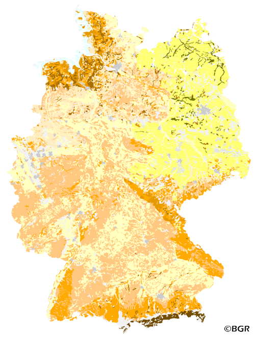
Organic Matter Content of Top-Soils in Germany 1:1,000,000
The map Organic Matter Content of Top-Soils in Germany 1:1,000,000 highlights the results of a Germany-wide compilation of typical soil organic matter contents in top-soils differentiated according to 15 groups of soil parent material, four climatic areas and the main land use. The evaluation is based on more than 9000 soil data profiles with information about Soil Organic Matter (SOM) from a period of about 20 years. The report 'The Organic Matter Content of Top-Soils in Germany', BGR Archiv, No. 0127036 (in German) documents the methodology. The classes of the map legend are based on the classes given in the German Soil Mapping Guideline, 5th Edition (KA5).
|
|
Citation proposal
(2007) . Organic Matter Content of Top-Soils in Germany 1:1,000,000. https://gdk.gdi-de.org/geonetwork/srv/api/records/02F23B5B-5FB8-48BA-ADDA-7ECA7481C4DE |
- Identification
- Distribution
- Quality
- Spatial rep.
- Ref. system
- Content
- Portrayal
- Metadata
- Md. constraints
- Md. maintenance
- Schema info
Identification
Data identification
Citation
- Alternate title
- HUMUS1000OB
- Date ( Creation )
- 2007-07-05
- Date ( Publication )
- 2007-07-10
- Edition
- Version 2.0
- Identifier
- a2b39d17-661b-426f-929e-36d2925a029a
Author
- Status
- completed Completed
Point of contact
Bundesanstalt für Geowissenschaften und Rohstoffe (BGR)
-
Stange, Florian, Dr.
Stilleweg 2
Hannover
30655
DE
- GEMET - INSPIRE themes, version 1.0 ( Theme )
-
- Boden
- Soil
- GEMET - Concepts, version 2.4 ( Theme )
-
- Bodenart
- Bodenauslaugung
- Bodenbearbeitung
- Bodenbelastung
- Bodenbildung
- Bodenbiologie
- Bodenchemie
- Bodendegradation
- Bodendekontamination
- Bodenerosion
- Bodenfeuchtigkeit
- Bodenfruchtbarkeit
- Bodenfunktion
- Bodengestaltung
- Bodenkarte
- Bodenluft
- Bodenmechanik
- Bodenmineralogie
- Bodennutzbarkeit
- Bodennutzung
- SGD-Liste ( Theme )
-
- Bodeneigenschaften
- Bodengefüge
- Bodengruppe
- Bodenhorizont
- bodenphysikalische Eigenschaften
- Bodenskelett
- Bodenverbreitung
- Durchlässigkeit
- effektive Durchwurzelungstiefe
- Freies Schlagwort ( Theme )
-
- Bodenausgangsgestein
- Bodengesellschaft
- Bodeninformationssystem
- Bodensystematik
- Corg
- Fachinformationssystem
- Humusgehalt
- inspireidentifiziert
- opendata
- Keywords ( Place )
-
- Bundesrepublik Deutschland
- Spatial scope
-
- National
- High-value dataset categories
-
- Erdbeobachtung und Umwelt
Legal constraints
- Access constraints
- Other restrictions
Legal constraints
- Use constraints
- Other restrictions
- Other constraints
- Allgemeine Geschäftsbedingungen, siehe https://www.bgr.bund.de/AGB - General terms and conditions, see https://www.bgr.bund.de/AGB_en. Die bereitgestellten Informationen sind bei Weiterverwendung wie folgt zu zitieren: Datenquelle: HUMUS1000OB V2.0, (C) BGR, Hannover, 2007.
- Other constraints
- Dieser Datensatz kann gemäß der "Nutzungsbestimmungen für die Bereitstellung von Geodaten des Bundes" (https://sg.geodatenzentrum.de/web_public/gdz/lizenz/geonutzv.pdf) genutzt werden.
- Other constraints
- {"id": "geoNutz/20130319", "name": "Nutzungsbestimmungen für die Bereitstellung von Geodaten des Bundes", "url": "https://sg.geodatenzentrum.de/web_public/gdz/lizenz/geonutzv.pdf", "quelle": "HUMUS1000OB V2.0, (C) BGR, Hannover, 2007"}
- Spatial representation type
- Vector
- Denominator
- 1000000
- Metadata language
- ger German
- Character set
- utf8 UTF8
- Topic category
-
- Geoscientific information
N
S
E
W
))
- Geographic identifier
- Regionalschlüssel / 000000000000
Distribution
Distribution
- Distribution format
-
- PDF (n/a )
- Shapefile (n/a )
- JPEG (n/a )
- PNG (n/a )
- TIFF (n/a )
Digital transfer options
- Transfer size
- 10
- OnLine resource
-
HUMUS1000OB (PDF)
HUMUS1000OB im Format Adobe Acrobat
Digital transfer options
- Transfer size
- 10
- OnLine resource
-
HUMUS1000OB (Shapefile)
HUMUS1000OB im Format ESRI Shape
Digital transfer options
- Transfer size
- 23
- OnLine resource
-
HUMUS1000OB (JPEG)
HUMUS1000OB im Format JPEG (Auflösung 300 dpi)
Digital transfer options
- Transfer size
- 17
- OnLine resource
-
HUMUS1000OB (PNG)
HUMUS1000OB im Format PNG (Auflösung 150 dpi)
Digital transfer options
- Transfer size
- 18
- OnLine resource
-
HUMUS1000OB (TIFF)
HUMUS1000OB im Format TIFF (Auflösung 300 dpi)
- OnLine resource
-
HUMUS1000OB Internetseite - HUMUS1000OB Website
HUMUS1000OB Internetseite - HUMUS1000OB Website
- OnLine resource
-
Bericht über länderübergreifende Auswertungen von Punktinformationen im FISBo BGR -
Bericht über länderübergreifende Auswertungen von Punktinformationen im FISBo BGR -
- OnLine resource
-
Karte im BGR-Geoviewer
Karte im BGR-Geoviewer
Quality
Data quality
Scope
- Hierarchy level
- Dataset
Conformance result
Citation
- Date ( Publication )
- 2010-12-08
- Explanation
- siehe dazu die angegebene Durchführungsbestimmung
- Statement
- Labor- und Profildatenbank im FISBo BGR; zusätzliche Datenbereitstellung durch die SGD (AG Boden).
Metadata
Metadata
- File identifier
- 02F23B5B-5FB8-48BA-ADDA-7ECA7481C4DE XML
- Metadata language
- German
- Character set
- utf8 UTF8
- Hierarchy level
- dataset Dataset
- Hierarchy level name
- Boden
- Date stamp
- 2024-04-23
- Metadata standard name
- INSPIRE Metadata Implementing Rules: Technical Guidelines based on EN ISO 19115 and EN ISO 19119
- Metadata standard version
- n/a
Point of contact
Overviews
Provided by

Views
02F23B5B-5FB8-48BA-ADDA-7ECA7481C4DE
Access to the portal
Read here the full details and access to the data.
Associated resources
Not available