 www.geodatenkatalog.de (S1F)
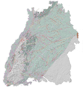
LGRB-BW 3D: Schichtlagerung der Buntsandsteinbasis
Die Karte zeigt die Raumlage der Buntsandsteinbasis. Ergänzend sind der Ausstrich, die Verbreitung, überregionale bruchtektonische Elemente und eine Auswahl von Belegpunkten abgebildet.
|
|
Citation proposal
. LGRB-BW 3D: Schichtlagerung der Buntsandsteinbasis. https://gdk.gdi-de.org/geonetwork/srv/api/records/04c3d788-34ed-4de0-a3cd-9f8c3d10440d |
- Identification
- Distribution
- Quality
- Spatial rep.
- Ref. system
- Content
- Portrayal
- Metadata
- Md. constraints
- Md. maintenance
- Schema info
Identification
Data identification
Citation
- Alternate title
- 3D: Schichtlagerung der Buntsandsteinbasis
- Date ( Revision )
- 2007-12-31
- Status
- Completed
Point of contact
- Keywords
-
- Geologie
- GDI-BW-Schlüsselwortliste nach dem mehrsprachigen Umwelt-Thesaurus GEMET
-
- Geologie
- Simulation
Legal constraints
- Use constraints
- Other restrictions
- Other constraints
- https://produkte.lgrb-bw.de/agb/
- Metadata language
- German
- Character set
- UTF8
N
S
E
W
))
- Supplemental Information
- Die Raumlage der Buntsandsteinbasis ist als Übersichtsdarstellung gedacht und wurde auf der Grundlage ausgesuchter Stützstellen nach bestem Wissen konstruiert. Es wird jedoch keine Gewähr für die Vollständigkeit, Richtigkeit, Aktualität oder Qualität übernommen. Die Karten sind urheberrechtliches Eigentum des RP Freiburg, Abt. 9 LGRB und dürfen nur mit Quellenangabe genutzt werden.
Distribution
Distribution
Distributor
Point of contact
Standard order process
- Fees
- Daten nicht im Vertrieb, Verfügbarkeit/Preis auf Anfrage
- Ordering instructions
- https://produkte.lgrb-bw.de/product?group=15815&item=6470
- OnLine resource
- WMS LGRB-BW 3D: Geologisches 3D-Landesmodell 1 : 500 000
Quality
- Hierarchy level
- Dataset
Ref. system
- Reference system identifier
- EPSG / EPSG:25832
- Reference system identifier
- EPSG / EPSG:31467
- Reference system identifier
- EPSG / EPSG:4326
- Reference system identifier
- EPSG / EPSG:3857
Metadata
Metadata
- File identifier
- 04c3d788-34ed-4de0-a3cd-9f8c3d10440d XML
- Metadata language
- German
- Character set
- UTF8
- Hierarchy level
- Dataset
- Date stamp
- 2021-05-05T17:08:24
- Metadata standard name
- ISO 19115:2003 (GDI-BW)
- Metadata standard version
- 2.1
Overviews
thumbnail
Provided by

Views
04c3d788-34ed-4de0-a3cd-9f8c3d10440d
Access to the portal
Read here the full details and access to the data.
Associated resources
Not available