 www.geodatenkatalog.de (S3L)
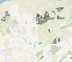
Flächen für Windenergie in Niedersachsen
Vorrangflächen für Windenergie werden in den digitalen Flächennutzungsplänen von Plandigital abgebildet und dienen als Grundlage für die kommunale und regionale Planung. Es erfolgt eine Filterung aus den Gebietsklassen "Bauland" und "Ver- und Entsorgung" und eine gesonderte Darstellung dieser Bereiche. Die Daten werden wöchentlich aus Plandigital aktualisiert.
|
|
Citation proposal
. Flächen für Windenergie in Niedersachsen. https://gdk.gdi-de.org/geonetwork/srv/api/records/0634230a-1f5b-4e4f-b0b5-32fb240e26cc |
INSPIRE
Identification
- File identifier
- 0634230a-1f5b-4e4f-b0b5-32fb240e26cc XML
- Hierarchy level
- dataset Dataset
Online resource
Resource identifier
- Metadata language
- German
Encoding
Projection
- code
- CRS 84: CRS 84 / mathematisch
Classification of data and services
- Topic category
-
- Environment
Classification of data and services
Coupled resource
Coupled resource
Classification of data and services
Coupled resource
Coupled resource
Keywords
- UMTHES Thesaurus ( Theme )
- GEMET - Concepts, version 3.1 ( Theme )
Other keywords
- Keywords
-
- Vorrangflächen
- digitale Flächennutzungspläne
- Plandigital
- kommunale Planung
- regionale Planung
Geographic coverage
N
S
E
W
))
N
S
E
W
Temporal reference
Temporal extent
Temporal extent
- Date ( Creation )
- 2025-07-30T00:00:00.000+02:00
Quality and validity
- Lineage
- Vorrangflächen für Windenergie werden in den digitalen Flächennutzungsplänen von Plandigital abgebildet und dienen als Grundlage für die kommunale und regionale Planung. Es erfolgt eine Filterung aus den Gebietsklassen "Bauland" und "Ver- und Entsorgung" und eine gesonderte Darstellung dieser Bereiche. Die Daten werden wöchentlich aus Plandigital aktualisiert.
Conformity
Conformity
Conformity
Conformity
Conformity
Conformity
Restrictions on access and use
- Access constraints
- Datenlizenz Deutschland – Zero – Version 2.0
- Access constraints
- {"id":"dl-zero-de/2.0","name":"Datenlizenz Deutschland – Zero – Version 2.0","url":"https://www.govdata.de/dl-de/zero-2-0","quelle":""}
Restrictions on access and use
Responsible organization (s)
Contact for the resource
- Organisation name
- Niedersächsisches Ministerium für Umwelt, Energie und Klimaschutz
Responsible organization (s)
Contact for the resource
- Organisation name
- Niedersächsisches Ministerium für Umwelt, Energie und Klimaschutz
Metadata information
Contact for the metadata
- Organisation name
- Niedersächsisches Ministerium für Umwelt, Energie und Klimaschutz
- Date stamp
- 2025-09-04
- Metadata language
- German
SDS
Conformance class 1: invocable
Access Point URL
Endpoint URL
Technical specification
Conformance class 2: interoperable
Coordinate reference system
Quality of Service
Access constraints
Limitation
Use constraints
Limitation
Responsible custodian
Contact for the resource
Conformance class 3: harmonized
Overviews
Provided by

Views
0634230a-1f5b-4e4f-b0b5-32fb240e26cc
Access to the portal
Read here the full details and access to the data.
Associated resources
Not available