 www.geodatenkatalog.de (S1L)
Marine Seismic Survey Profiles (MSSP)
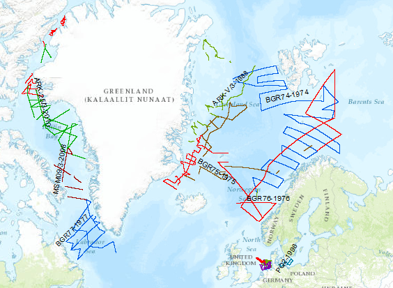
During the period from 1974 to 2023 various cruises from BGR acquired seismic lines worldwide. The aim of these marine expeditions were a detailed survey of the geological structure of seabed.
|
|
Citation proposal
. Marine Seismic Survey Profiles (MSSP). https://gdk.gdi-de.org/geonetwork/srv/api/records/06a73c56-06a2-40d8-b806-466222b0760d |
- Identification
- Distribution
- Quality
- Spatial rep.
- Ref. system
- Content
- Portrayal
- Metadata
- Md. constraints
- Md. maintenance
- Schema info
Identification
Data identification
Citation
- Alternate title
- MSSP
- Date ( Creation )
- 2015-01-01
- Date ( Revision )
- 2023-10-12
- Identifier
- b2c0c25b-1a34-42cb-bcfb-8314a7e3bb6e
- Status
- onGoing On going
Point of contact
- GEMET - INSPIRE themes, version 1.0 ( Theme )
-
- geology
- Geologie
- GEMET - Concepts, version 2.4 ( Theme )
-
- raw material
- Rohstoff
- marine geology
- Meeresgeologie
- geophysics
- Geophysik
- Keywords ( Theme )
-
- two-dimensional seismic reflection
- zweidimensionale Reflektionsseismik
- seismics
- Seismik
- MSSP
- GeolDG
- Keywords ( Place )
-
- North Sea
- Nordsee
- Baltic Sea
- Ostsee
- Arctic Ocean
- Arktis
- North Atlantic
- Nordatlantik
- Barentssea
- Barentssee
- Norwegian Sea
- Norwegische See
- Labrador Sea
- Labradorsee
- Baffin Bay
- Baffin Bucht
- Laptev Sea
- Laptevsee
Legal constraints
- Access constraints
- Other restrictions
Legal constraints
- Use constraints
- Other restrictions
- Other constraints
- Allgemeine Geschäftsbedingungen, siehe https://www.bgr.bund.de/AGB - General terms and conditions, see https://www.bgr.bund.de/AGB_en. Die bereitgestellten Informationen sind bei Weiterverwendung wie folgt zu zitieren: Datenquelle: MSSP, (c) BGR, Hannover, 2023
- Spatial representation type
- Vector
- Metadata language
- German
- Character set
- UTF8
- Topic category
-
- Geoscientific information
N
S
E
W
))
Distribution
Distribution
- Distribution format
-
- shp (n/a )
- OnLine resource
-
Karte im BGR-Geoviewer
Karte im BGR-Geoviewer
Quality
Data quality
Scope
- Hierarchy level
- Series
Conformance result
Citation
- Date ( Publication )
- 2010-12-08
- Explanation
- siehe dazu die angegebene Durchführungsbestimmung
- Statement
- The described lines are the routes of research ship. Along these lines profiles are surveyed by a high-resolution multichannel seismic system and stored in SEG Y format, which are available at BGR as processed (migrated/stacked) or raw data.
Metadata
Metadata
- File identifier
- 06a73c56-06a2-40d8-b806-466222b0760d XML
- Metadata language
- English
- Character set
- UTF8
- Hierarchy level
- Series
- Hierarchy level name
- Geophysik
- Hierarchy level name
- GeolDG
- Date stamp
- 2024-03-04
- Metadata standard name
- INSPIRE Metadata Implementing Rules: Technical Guidelines based on EN ISO 19115 and EN ISO 19119
- Metadata standard version
- n/a
Point of contact
Overviews
Provided by

Views
06a73c56-06a2-40d8-b806-466222b0760d
Access to the portal
Read here the full details and access to the data.
Associated resources
Not available