 My GeoNetwork catalogue
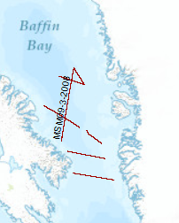
Processed seismic data of Cruise MSM9/3
The cruise leg MSM09/3 was conducted as a cooperative project between the Alfred Wegener Institute for Polar and Marine Research (AWI), the Federal Institute for Geosciences and Resources (BGR), the Geological Survey of Denmark and Greenland (GEUS) and Dalhousie University. The data format is Society of Exploration Geophysicists SEG Y. A geophysical survey covered areas of Baffin Bay and Davis Strait between Greenland and the Canadian Baffin Island. A component of the IPY 2007/08 Lead Project Plate Tectonics and Polar Gateways in the Earth System (PLATES & GATES), this project DAVIS GATE is aimed to develop a tectonic and sedimentary reconstruction of the opening process of this oceanic gateway. Baffin Bay and Davis Strait play an important role in the shallow water exchange from the Arctic to the Atlantic Ocean. The plate-tectonic evolution as well as the magmatic history of this region has been sparsely known and required a careful geophysical investigation in order to construct a set of gridded detailed paleotopographic maps for a complete geodynamic reconstruction of this gateway. With a set of three seismic refraction/wide-angle reflection profiles, using ocean-bottom seismometers on 62 stations, as well as multi-channel reflection seismic recordings with a 3000-m long streamer, data were acquired from the sedimentary cover to the deep crust and even from parts of the uppermost mantle. Additional seismic data supplement these profiles and provide insights into the structures of the basement and dominant fault zones such as the Ungava fault system. A parallel running magnetic survey aimed to resolve the temporal evolution of the oceanic crust of Baffin Bay. The extension and subsidence of the continental and transitional crust in the Davis Strait and the evolution of oceanic crust in the Labrador Sea and Baffin Bay could be investigated with dataset to which continuously recorded gravity anomaly data and sub-bottom profiler data also contribute. This dataset provides the basis of geometrical and physical properties of the crust required for a realistic geodynamic model which will describe the break-up and the ocean basin evolution between Greenland and Canada in terms of detailed paleo-topography.
INSPIRE
Identification
- File identifier
- 0808f95d-8a60-45a8-ba0f-e06820b6bcca XML
- Hierarchy level
- Dataset
Online resource
Resource identifier
- code
-
859f0f42-de46-4e88-af1f-26c241b8df53
- Metadata language
- English
- Spatial representation type
- Vector
Encoding
- Format
-
Shapefile
- Version
-
n/a
Projection
- code
- EPSG:4326
Classification of data and services
- Topic category
-
- Geoscientific information
Classification of data and services
Coupled resource
Coupled resource
Classification of data and services
Coupled resource
Coupled resource
Keywords
-
GEMET - INSPIRE themes, version 1.0
-
-
geology
-
Geologie
-
-
GEMET - Concepts, version 2.4
-
-
marine geology
-
Meeresgeologie
-
geophysics
-
Geophysik
-
raw material
-
Rohstoff
-
Other keywords
- Theme
-
-
seismics
-
Seismik
-
two-dimensional seismic reflection
-
zweidimensionale Reflektionsseismik
-
MSSP
-
- Place
-
-
Davis Strait
-
Davis Straße
-
Geographic coverage
))
Temporal reference
Temporal extent
Temporal extent
- Date (Creation)
- 2008-10-21
Quality and validity
- Lineage
-
During the period from 9th of September to 29th of October 2008 BGR acquired seismic lines in the Davis Strait. The Lines BGR08-301, BGR08-304, BGR08-305, BGR08-306, BGR08-313, BGR08-315, BGR08-319 are processed (stack) data, whereas lines BGR08-303. BGR08-303A are raw data.
Conformity
Conformity
Conformity
Conformity
Conformity
Conformity
- Explanation
-
siehe dazu die angegebene Durchführungsbestimmung
Restrictions on access and use
- Access constraints
- Es gelten keine Zugriffsbeschränkungen
- Access constraints
-
Allgemeine Geschäftsbedingungen, siehe https://www.bgr.bund.de/AGB - General terms and conditions, see https://www.bgr.bund.de/AGB_en . Die bereitgestellten Informationen sind bei Weiterverwendung wie folgt zu zitieren: Datenquelle: BGR08, (c) BGR, Hannover, 2008
Responsible organization (s)
Contact for the resource
- Organisation name
-
Federal Institute for Geosciences and Natural Resources
Responsible organization (s)
Contact for the resource
- Organisation name
-
Federal Institute for Geosciences and Natural Resources
Metadata information
Contact for the metadata
- Organisation name
-
Bundesanstalt für Geowissenschaften und Rohstoffe (BGR)
- Date stamp
- 2025-04-07
- Metadata language
- English
- Character set
- UTF8
SDS
Conformance class 1: invocable
Access Point URL
Endpoint URL
Technical specification
Conformance class 2: interoperable
Access constraints
Limitation
Use constraints
Limitation
Responsible custodian
Contact for the resource
Overviews
Spatial extent
Provided by
