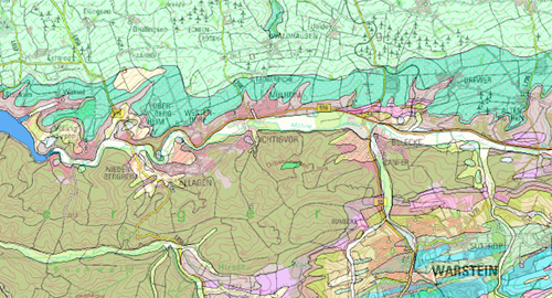
IS GK 100 WMS - Informationssystem Geologische Karte von Nordrhein-Westfalen 1:100.000 - Darstellungsdienst
Dieser WMS stellt das Informationssystem Geologische Karte von Nordrhein-Westfalen 1:100.000 [IS GK 100] dar. Die Karte zeigt landesweit die Verbreitung der Gesteine in den Themenlayern Geologische Schichten; Geologische Deckschichten bis 2 Meter Tiefe; Tektonische Verwerfungen.
|
|
Citation proposal
(2009) . IS GK 100 WMS - Informationssystem Geologische Karte von Nordrhein-Westfalen 1:100.000 - Darstellungsdienst. https://gdk.gdi-de.org/geonetwork/srv/api/records/08EFDD69-F5CC-49FF-89F9-7FAA297791EB |
INSPIRE
Identification
- File identifier
- 08EFDD69-F5CC-49FF-89F9-7FAA297791EB XML
- Hierarchy level
- service Service
Online resource
Resource identifier
Encoding
Projection
Classification of data and services
Classification of data and services
- Service Type
- WMS
- Coupling Type
- Tight
Coupled resource
Coupled resource
Classification of data and services
- Service Type
- WMS
- Coupling Type
- Tight
Coupled resource
Coupled resource
Keywords
- UMTHES Thesaurus ( Theme )
-
- Geologie
- Untergrund
- Gestein
- Störung
- Verwerfung
- Service Classification, version 1.0 ( Theme )
-
- infoMapAccessService
Other keywords
- Keywords ( Discipline )
-
- Geologische Karte
- ISGK100
- Keywords
-
- opendata
- sgd_Geologie
Geographic coverage
N
S
E
W
))
Temporal reference
Temporal extent
Temporal extent
- Date ( Publication )
- 2009-01-01
- Date ( Revision )
- 2016-02-23
Quality and validity
- Lineage
- Informationssystem GK 100
Conformity
Conformity
Conformity
Conformity
Conformity
Conformity
Restrictions on access and use
Restrictions on access and use
- Access constraints
- Nutzungsbedingungen: {"id":"dl-by-de/2.0", "name": "Datenlizenz Deutschland Namensnennung 2.0", "url": "https://www.govdata.de/dl-de/by-2-0", "IS GK 100 WMS, Geologischer Dienst NRW, Jahr des Abrufs"}
Responsible organization (s)
Contact for the resource
- Organisation name
- Geologischer Dienst NRW
- geodaten@gd.nrw.de
Responsible organization (s)
Contact for the resource
- Organisation name
- Geologischer Dienst NRW
- geodaten@gd.nrw.de
Metadata information
Contact for the metadata
- Organisation name
- Geologischer Dienst NRW
- metadaten@gd.nrw.de
- Date stamp
- 2024-09-19
- Metadata language
- ger German
SDS
Conformance class 1: invocable
Access Point URL
Endpoint URL
Technical specification
Conformance class 2: interoperable
Coordinate reference system
Quality of Service
Access constraints
- Access constraints
- Other restrictions
Limitation
Use constraints
Limitation
- string
- Nutzungsbedingungen: {"id":"dl-by-de/2.0", "name": "Datenlizenz Deutschland Namensnennung 2.0", "url": "https://www.govdata.de/dl-de/by-2-0", "IS GK 100 WMS, Geologischer Dienst NRW, Jahr des Abrufs"}
Responsible custodian
Contact for the resource
Conformance class 3: harmonized
Contains Operations
- Operation Name
- GetCapabilities
- Distributed Computing Platforms
- HTTPGet
- Invocation Name
- GetCapabilities
Parameter
- Name
- REQUEST=GetCapabilities
- Name
- Optionality
- 0
- Repeatability
- false
- Name
Parameter
- Name
- VERSION=1.3.0
- Name
- Optionality
- 1
- Repeatability
- false
- Name
Parameter
- Name
- UPDATESEQUENCE=number
- Name
- Optionality
- 1
- Repeatability
- false
- Name
Parameter
- Name
- SERVICE=WMS
- Name
- Optionality
- 0
- Repeatability
- false
- Name
Contains Operations
- Operation Name
- GetMap
- Distributed Computing Platforms
- HTTPGet
- Invocation Name
- GetMap
Parameter
- Name
- SRS=namespace:identifier
- Name
- Optionality
- 0
- Repeatability
- false
- Name
Parameter
- Name
- EXCEPTIONS=exception_format
- Name
- Optionality
- 1
- Repeatability
- false
- Name
Parameter
- Name
- WFS=web_feature_service_URL
- Name
- Optionality
- 1
- Repeatability
- false
- Name
Parameter
- Name
- WIDTH=output_width
- Name
- Optionality
- 0
- Repeatability
- false
- Name
Parameter
- Name
- SLD=styled_layer_descriptor_URL
- Name
- Optionality
- 1
- Repeatability
- false
- Name
Parameter
- Name
- VERSION=1.3.0
- Name
- Optionality
- 0
- Repeatability
- false
- Name
Parameter
- Name
- BGCOLOR=color_value
- Name
- Optionality
- 1
- Repeatability
- false
- Name
Parameter
- Name
- REQUEST=GetMap
- Name
- Optionality
- 0
- Repeatability
- false
- Name
Parameter
- Name
- Vendor-specific parameters
- Name
- Optionality
- 1
- Repeatability
- false
- Name
Parameter
- Name
- BBOX=minx,miny,maxx,maxy
- Name
- Optionality
- 0
- Repeatability
- false
- Name
Parameter
- Name
- ELEVATION=elevation
- Name
- Optionality
- 1
- Repeatability
- false
- Name
Parameter
- Name
- TRANSPARENT=TRUE|FALSE
- Name
- Optionality
- 1
- Repeatability
- false
- Name
Parameter
- Name
- HEIGHT=output_height
- Name
- Optionality
- 0
- Repeatability
- false
- Name
Parameter
- Name
- LAYERS=layer_list
- Name
- Optionality
- 0
- Repeatability
- false
- Name
Parameter
- Name
- STYLES=style_list
- Name
- Optionality
- 0
- Repeatability
- false
- Name
Parameter
- Name
- Other sample dimension(s)
- Name
- Optionality
- 1
- Repeatability
- false
- Name
Parameter
- Name
- FORMAT=output_format
- Name
- Optionality
- 0
- Repeatability
- false
- Name
Parameter
- Name
- TIME=time
- Name
- Optionality
- 1
- Repeatability
- false
- Name
- Connect Point
- https://www.wms.nrw.de/gd/GK100?
Overviews

Provided by

Views
08EFDD69-F5CC-49FF-89F9-7FAA297791EB
Access to the portal
Read here the full details and access to the data.
Associated resources
Not available
 www.geodatenkatalog.de (S3L)