 www.geodatenkatalog.de (S3L)
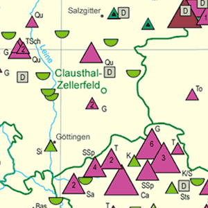
Map of Mining and Storage Operations of the Federal Republic of Germany 1:2,000,000 (BergSP)
This record is out of date: The 'Map of Mining and Storage Operations of the Federal Republic of Germany' on a scale of 1:2,000,000 is published by the Bundesanstalt für Geowissenschaften und Rohstoffe (Federal Institute for Geosciences and Natural Resources) in cooperation with the mining authorities of the federal states. It shows the locations of mining operations for coal, lignite, petroleum, natural gas, raw material, iron and manganese ore and salt. The annual deliveries are presented in six categories. The storage operations for petroleum, natural gas, compressed air and waste disposal sites are distinguished by their type. Moreover, the map contains the locations of geothermal plants.
|
|
Citation proposal
(2019) . Map of Mining and Storage Operations of the Federal Republic of Germany 1:2,000,000 (BergSP). https://gdk.gdi-de.org/geonetwork/srv/api/records/09C9ACDA-28CA-4509-9DD2-2CFBFD4A47D9 |
Simple
- Alternate title
- BergSP
- Date ( Publication )
- 2019-12-20
- Edition
- 48. Auflage
- Identifier
- 03F2CCFD-723F-46CC-A1AD-FB79E336BD9B
Author
- Status
- obsolete Obsolete
Point of contact
- GEMET - INSPIRE themes, version 1.0 ( Theme )
-
- Energiequellen
- energy resources
- mineral resources
- Mineralische Bodenschätze
- GEMET - Concepts, version 2.4 ( Theme )
-
- Energie
- energy
- resources
- Ressourcen
- Ressourcennutzung
- SGD-Liste ( Theme )
-
- Abfallwirtschaft
- Basalt
- Deponie
- Erdgas
- Erdöl
- Granit
- Kristallingestein
- Lagerstättenerkundung
- Lockergestein
- mineralische Rohstoffe
- Ressourcenbewirtschaftung
- Sedimentgestein
- Steine und Erden
- Tagebau
- Keywords ( Theme )
-
- Bergbau
- Bergbaubetrieb
- Bergwerk
- Jahresförderung
- Kavernenspeicher
- Porenspeicher
- Rohstoffgeologie
- Speicherbetrieb
- Keywords ( Place )
-
- Bundesrepublik Deutschland
- Access constraints
- Other restrictions
- Use constraints
- Other restrictions
- Other constraints
- Allgemeine Geschäftsbedingungen, siehe https://www.bgr.bund.de/AGB - General terms and conditions, see https://www.bgr.bund.de/AGB_en. Die bereitgestellten Informationen sind bei Weiterverwendung wie folgt zu zitieren: Datenquelle: BergSP, (c) BGR, Hannover, 2019
- Spatial representation type
- Grid
- Denominator
- 2000000
- Metadata language
- ger German
- Character set
- utf8 UTF8
- Topic category
-
- Geoscientific information
N
S
E
W
))
- Geographic identifier
- Regionalschlüssel / 000000000000
- Distribution format
-
- PDF (n/a )
- Transfer size
- 2
- OnLine resource
-
BergSP (PDF)
BergSP im Format Adobe Acrobat Datei (Auflösung 300 dpi)
- OnLine resource
-
BergSP-Internetseite - BergSP-Website
BergSP-Internetseite - BergSP-Website
- Hierarchy level
- Dataset
- Statement
- Aktualisierung der Daten durch die Bergbehörden der Bundesländer, Zusammenführung der Daten durch das Landesamt für Bergbau, Energie und Geologie und die Bundesanstalt für Geowissenschaften und Rohstoffe
gmd:MD_Metadata
- File identifier
- 09C9ACDA-28CA-4509-9DD2-2CFBFD4A47D9 XML
- Metadata language
- German
- Character set
- utf8 UTF8
- Hierarchy level
- dataset Dataset
- Hierarchy level name
- Geologie
- Hierarchy level name
- Rohstoffe
- Date stamp
- 2023-07-18
- Metadata standard name
- INSPIRE Metadata Implementing Rules: Technical Guidelines based on EN ISO 19115 and EN ISO 19119
- Metadata standard version
- n/a
Point of contact
Overviews
Provided by

Views
09C9ACDA-28CA-4509-9DD2-2CFBFD4A47D9
Access to the portal
Read here the full details and access to the data.
Associated resources
Not available