 www.geodatenkatalog.de (S3L)
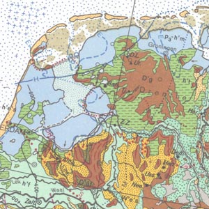
International Quaternary Map of Europe 1:2,500,000 (IQE2500) - Sheet 10 Bern
The idea to represent the main features of the European Quaternary was first discussed at the Second Congress of the International Union for Quaternary Research (INQUA) held in Leningrad (St. Petersburg) in 1932. Compiled by the Federal Institute for Geosciences and Natural Resources (BGR) in cooperation with the INQUA, the International Quaternary Map of Europe 1 : 2.500.000 was finished in 1995. It is jointly published by the BGR and UNESCO. Several Quaternary features such as end moraines, ground moraine hillocks, kames, drumlins, eskers and ice border lines are represented on the map. Additionally, the map shows the directions of ice movements, limits of marine transgressions and tectonic faults. Important localities of Quaternary discovery relating to both geology and prehistory, bathymetric lines and recent deposits covering the sea floor are also indicated as well. The legend on each of the 14 map sheets is in German and, depending on the territories covered, in English, French or Russian. The general legend is placed on map sheet number 15.
|
|
Citation proposal
(1995) . International Quaternary Map of Europe 1:2,500,000 (IQE2500) - Sheet 10 Bern. https://gdk.gdi-de.org/geonetwork/srv/api/records/0E72567D-4BFA-4F04-A1C4-7DFC7F2A7272 |
Simple
- Alternate title
- IQE2500 - Blatt 10 Bern
- Date ( Publication )
- 1995-09-30
- Identifier
- D12CA8B2-2A2B-4708-B7B3-A67F3534AFE7
Author
- Other citation details
- Die Generallegende ist bei den digitalen Ausgaben beigefügt. Größe gedruckte Karte: 104,5 x 65,8 cm - The general legend is added to the digital edition. Size of printed map: 104.5 x 65.8 cm
- Status
- completed Completed
Point of contact
Bundesanstalt für Geowissenschaften und Rohstoffe
-
Asch, Kristine, Dr.
Stilleweg 2
Hannover
30655
DE
- GEMET - INSPIRE themes, version 1.0 ( Theme )
-
- Geologie
- Geology
- GEMET - Concepts, version 2.4 ( Theme )
-
- Tectonic
- Tektonik
- Keywords ( Theme )
-
- archäologische Fundstelle
- Bathymetrie
- Eisrandlage
- Eisscheide
- Endmoräne
- Genese
- Gletscher
- Grundmoräne
- Meeresbodenbedeckung
- Paläolithisch
- Petrographie
- Quartär
- Sedimentverteilung
- Torf
- Transgressionen
- Treibeisgrenze
- Vereisungsphasen
- Vulkan
- Keywords ( Place )
-
- B
- Keywords ( Place )
-
- D
- Keywords ( Place )
-
- I
- Keywords ( Place )
-
- HR
- Keywords ( Place )
-
- BIH
- Keywords ( Place )
-
- SLO
- Keywords ( Place )
-
- A
- Keywords ( Place )
-
- CZ
- Keywords ( Place )
-
- SK
- Keywords ( Place )
-
- CH
- Keywords ( Place )
-
- F
- Keywords ( Place )
-
- L
- Keywords ( Place )
-
- FL
- Keywords ( Place )
-
- M
- Access constraints
- Other restrictions
- Use constraints
- Other restrictions
- Other constraints
- Allgemeine Geschäftsbedingungen, s. https://www.bgr.bund.de/agb - General Terms and Conditions, s. https://www.bgr.bund.de/agb_en
- Other constraints
- Preis der gedruckten Karte: 18,69 EUR (zzgl. 7% MWSt. und Versandkosten) Weitere Informationen zur Bestellung beim Internationalen Landkartenhaus siehe https://www.bgr.bund.de/produktcenter-bestellhinweis-ILH
- Spatial representation type
- Grid
- Denominator
- 2500000
- Metadata language
- eng English
- Character set
- utf8 UTF8
- Topic category
-
- Geoscientific information
N
S
E
W
))
- Distribution format
-
- PDF (n/a )
- JPEG (n/a )
- TIFF (n/a )
- gedruckt (n/a )
- georef. TIFF (n/a )
- Transfer size
- 3
- OnLine resource
-
IQE2500 - Blatt 10 Bern (PDF)
IQE2500 - Blatt 10 Bern im Format Adobe Acrobat Datei (geringe Auflösung)
- Transfer size
- 8
- OnLine resource
-
IQE2500 - Blatt 10 Bern (JPEG)
IQE2500 - Blatt 10 Bern im Format JPEG (Auflösung 150 dpi)
- Transfer size
- 245
- OnLine resource
-
IQE2500 - Blatt 10 Bern (TIFF)
IQE2500 - Blatt 10 Bern im Format TIFF (Auflösung 300 dpi)
- OnLine resource
-
IQE2500 - Blatt 10 Bern (gedruckt)
IQE2500 - Blatt 10 Bern im Format gedruckt, gefalzt
- Transfer size
- 186
- OnLine resource
-
IQE2500 - Blatt 10 Bern (georef. TIFF)
IQE2500 - Blatt 10 Bern im Format georeferenziertes Tiff
- OnLine resource
-
Webseite zum Kartenwerk - IQE-Website
Webseite zum Kartenwerk - IQE-Website
- OnLine resource
-
Indexkarte
Indexkarte
- Hierarchy level
- Dataset
- Statement
- -
gmd:MD_Metadata
- File identifier
- 0E72567D-4BFA-4F04-A1C4-7DFC7F2A7272 XML
- Metadata language
- German
- Character set
- utf8 UTF8
- Parent identifier
- A594DD7B-2BE7-4502-8308-AB8DAAD99EB2
- Hierarchy level
- dataset Dataset
- Hierarchy level name
- Geologie
- Date stamp
- 2025-10-17
- Metadata standard name
- INSPIRE Metadata Implementing Rules: Technical Guidelines based on EN ISO 19115 and EN ISO 19119
- Metadata standard version
- n/a
Point of contact
Overviews
Provided by

Views
0E72567D-4BFA-4F04-A1C4-7DFC7F2A7272
Access to the portal
Read here the full details and access to the data.
Associated resources
Not available