 www.geodatenkatalog.de (S1L)
Mobilitaet - 18 bis 21 Uhr
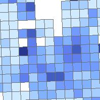
Der Kartendienst (WMS Gruppe) stellt Geodaten aus dem Bereich Mobilität im Saarland dar.:Raster 1000m symbolisiert nach dem Attribut "Anteil attraktiver Wege ÖV" im Zeitraum zwischen 18 und 21 Uhr.
|
|
Citation proposal
. Mobilitaet - 18 bis 21 Uhr. Ministerium für Umwelt, Klima, Mobilität, Agrar und Verbraucherschutz https://gdk.gdi-de.org/geonetwork/srv/api/records/0b1ccdeb-e45e-d79b-7082-4f440459922f |
INSPIRE
Identification
- File identifier
- 0b1ccdeb-e45e-d79b-7082-4f440459922f XML
- Hierarchy level
- service Service
Online resource
- Protocol
- OGC:WMS-1.1.1-http-get-map
Resource identifier
Encoding
Projection
Classification of data and services
Classification of data and services
- Service Type
- view
- Coupling Type
- Tight
Coupled resource
Coupled resource
Classification of data and services
- Service Type
- view
- Coupling Type
- Tight
Coupled resource
Coupled resource
Keywords
Other keywords
- Keywords
-
- ÖPNV
- Raster
- ÖV
- On-Demand
- Potential
- Analyse
- 1000
- Zeitintervall
- infoMapAccessService
- verkehrswesen
Geographic coverage
N
S
E
W
))
Temporal reference
Temporal extent
Temporal extent
- Date ( Revision )
- 2025-04-15
Quality and validity
Conformity
Conformity
Conformity
Conformity
Conformity
Conformity
- Explanation
- No explanation available
- Explanation
- No explanation available
- Explanation
- No explanation available
- Explanation
- No explanation available
- Explanation
- No explanation available
- Explanation
- No explanation available
- Explanation
- No explanation available
- Explanation
- No explanation available
Restrictions on access and use
Restrictions on access and use
Responsible organization (s)
Contact for the resource
- Organisation name
- Ministerium für Umwelt, Klima, Mobilität, Agrar und Verbraucherschutz
Responsible organization (s)
Contact for the resource
- Organisation name
- Ministerium für Umwelt, Klima, Mobilität, Agrar und Verbraucherschutz
Metadata information
Contact for the metadata
- Organisation name
- GDI-Saarland
- gdi-sl@lvgl.saarland.de
- Date stamp
- 2025-04-15
- Metadata language
- ger German
SDS
Conformance class 1: invocable
- Pass
- true
- Pass
- true
- Pass
- true
- Pass
- true
- Pass
- true
- Pass
- true
- Pass
- true
- Pass
- true
Access Point URL
Endpoint URL
Technical specification
- Date
- Explanation
- No explanation available
- Date
- Explanation
- No explanation available
- Date
- Explanation
- No explanation available
- Date
- Explanation
- No explanation available
- Date
- Explanation
- No explanation available
- Date
- Explanation
- No explanation available
- Date
- Explanation
- No explanation available
- Date
- Explanation
- No explanation available
Conformance class 2: interoperable
Coordinate reference system
Quality of Service
Access constraints
- Access constraints
- Other restrictions
Limitation
Use constraints
- Use constraints
- Other restrictions
Limitation
Responsible custodian
Contact for the resource
Conformance class 3: harmonized
Contains Operations
- Operation Name
- GetCapabilities
- Distributed Computing Platforms
- Web services
Overviews
Thumbnail
Provided by

Views
0b1ccdeb-e45e-d79b-7082-4f440459922f
Access to the portal
Read here the full details and access to the data.
Associated resources
Not available