 www.geodatenkatalog.de (S3L)
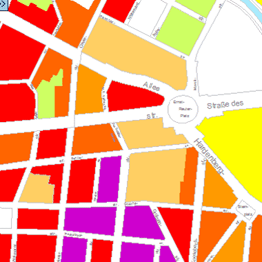
Einwohnerdichte 2004 (Umweltatlas)
Einwohnerdichte in Einwohner/ha auf Grundlage der Blockkarte 1 : 50.000 (ISU50, Raumbezug Umweltatlas 1990), Erfassungsstand 31.12.2004.
|
|
Citation proposal
(2005) . Einwohnerdichte 2004 (Umweltatlas). https://gdk.gdi-de.org/geonetwork/srv/api/records/10a41810-ec09-3eca-a0da-6340a28846cb |
- Identification
- Distribution
- Quality
- Spatial rep.
- Ref. system
- Content
- Portrayal
- Metadata
- Md. constraints
- Md. maintenance
- Schema info
Identification
Data identification
Citation
- Date ( Creation )
- 2005-08-01
- Date ( Publication )
- 2005-08-01
Point of contact
Point of contact
- Maintenance and update frequency
- Not planned
- Keywords ( Theme )
-
- open data
- opendata
- Karten
- Sachdaten
- Geodaten
- Berlin
- Bevölkerungsdichte
- Bevölkerungsentwicklung
- Bewohner
- Umweltatlas
- Dichte
- Einwohner
- AfS
- Amt für Statistik
- Einwohnerentwicklung
- Bevölkerungswachstum
- Melderegister
- Zensus-Fortschreibung
- Altersstruktur
- Einwohnerdichte
- Stadtentwicklung
- Räumlicher Anwendungsbereich ( Theme )
Legal constraints
- Access constraints
- Other restrictions
Legal constraints
- Use constraints
- Other restrictions
- Other constraints
- Der Datenbestand wird unter der Lizenz CC-BY-3.0-Namensnennung veröffentlicht (vgl. https://creativecommons.org/licenses/by/3.0/de/ ). Als Urheber ist dabei zu nennen: Amt für Statistik Berlin-Brandenburg
- Other constraints
- {"id":"cc-by-de/3.0","name":"Creative Commons - Namensnennung 3.0 Deutschland","url":"https://creativecommons.org/licenses/by/3.0/de/","quelle":"Amt für Statistik Berlin-Brandenburg"}
- Spatial representation type
- Vector
- Denominator
- 50000
- Metadata language
- German
- Character set
- UTF8
- Topic category
-
- Planning cadastre
Extent
N
S
E
W
))
Geographic description
- Extent type code
- true
- Geographic identifier
- 110000000000
Distribution
Distribution
- Distribution format
-
-
Text/HTML
(4.01 )
- Specification
- Keine Angabe
-
Text/HTML
(4.01 )
- OnLine resource
-
Darstellungsdienst - Einwohnerdichte 2004 (Umweltatlas) (WMS)
Darstellungsdienst - Einwohnerdichte 2004 (Umweltatlas) (WMS)
- OnLine resource
-
Downloaddienst - Einwohnerdichte 2004 (Umweltatlas) (WFS)
Downloaddienst - Einwohnerdichte 2004 (Umweltatlas) (WFS)
- OnLine resource
-
Inhaltliche Beschreibung
Inhaltliche Beschreibung
- OnLine resource
-
Technische Beschreibung
Technische Beschreibung
- OnLine resource
-
Umweltatlas, Karte 06.06
Umweltatlas, Karte 06.06
Quality
Data quality
- Hierarchy level
- Dataset
Lineage
- Statement
- Statistisches Landesamt Berlin, Stand 2005, Melderechtlich registrierte Einwohner am Ort der Hauptwohnung in Berlin am 31.12.2004
- Description
- Statistisches Landesamt Berlin, Stand 2005
- Description
- Melderechtlich registrierte Einwohner am Ort der Hauptwohnung in Berlin am 31.12.2004
Ref. system
- Reference system identifier
- http://www.opengis.net/def/crs/EPSG/0/25833
Metadata
Metadata
- File identifier
- 10a41810-ec09-3eca-a0da-6340a28846cb XML
- Metadata language
- German
- Character set
- UTF8
- Hierarchy level
- Dataset
- Date stamp
- 2025-11-19T00:00:00Z
- Metadata standard name
- ISO 19115/19119 - BE
- Metadata standard version
- 1.0.0
Point of contact
Overviews
Vorschaubild
Provided by

Views
10a41810-ec09-3eca-a0da-6340a28846cb
Access to the portal
Read here the full details and access to the data.
Associated resources
Not available