 My GeoNetwork catalogue
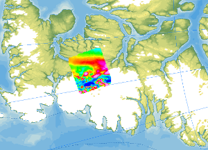
Helicopter-borne Magnetics CASE12
As part of the CASE 12 expedition, geological fieldwork and an aeromagnetic survey were conducted on Ellesmere Island (Canadian Arctic) in the summer of 2011. The helicopter-borne magnetic survey covered the ice-free areas between Vendom Fiord and Strathcona Fiord in the west and the ice-covered mountain ranges of the Inglefield Uplift in the east. With a total flight time of approx. 35 hours, 4200 line kilometres were flown covering a total area of 6000 km². The distance between the individual lines was 2 km, and control profiles perpendicular to the individual lines were flown every 10 km. The aeromagnetic data were recorded by a magnetometer, which was towed approx. 30 m beneath the helicopter.
Simple
- Alternate title
-
AeromagCASE12
- Date (Publication)
- 2023-02-22
- Citation identifier
- 6546c4bf-d318-8ca5-e18c-876eb3f4c893
- Status
- Completed
-
GEMET - INSPIRE themes, version 1.0
-
-
Geologie
-
Geology
-
-
GEMET - Concepts, version 2.4
-
-
Geophysik
-
- Theme
-
-
Aerogeophysik
-
Aeromagnetik
-
Anomalien des erdmagnetischen Feldes
-
Airborne geophysics
-
helicopter-borne /fixed-wing magnetics
-
anomalies of the Earth’s magnetic field
-
- Place
-
-
Arktis
-
Arctic
-
Nordpolargebiet
-
North Polar
-
Ellesmere Island
-
Vendom Fiord
-
- Access constraints
- Other restrictions
- Other constraints
- Es gelten keine Zugriffsbeschränkungen
- Use constraints
- Other restrictions
- Other constraints
-
Allgemeine Geschäftsbedingungen, siehe https://www.bgr.bund.de/AGB - General terms and conditions, see https://www.bgr.bund.de/AGB_en . Die bereitgestellten Informationen sind bei Weiterverwendung wie folgt zu zitieren: Datenquelle: AeromagCASE12, (c) BGR, Hannover, 2023
- Language
- English
- Character set
- UTF8
- Topic category
-
- Geoscientific information
))
- Unique resource identifier
- EPSG:3995
- Distribution format
-
-
GeoTIFF
(
n/a
)
-
shp
(
n/a
)
-
WMS
(
OGC:WMS1.3.0
)
-
GeoTIFF
(
n/a
)
- OnLine resource
-
AeromagCASE12 (GeoTIFF)
AeromagCASE12 im Format geoTiff
- OnLine resource
- Arktisforschung der BGR
- OnLine resource
- Karte im BGR-Geoviewer
- OnLine resource
-
Flightlines (Shape)
Flightlines im Format Shape
- Hierarchy level
- Dataset
- Statement
-
The aeromagnetic data were collected by BGR as part of the CASE program during the CASE 12 expedition on Ellesmere Island.
- File identifier
- 1179e1a4-d382-4385-a5cb-aac73426f25c XML
- Metadata language
- English
- Character set
- UTF8
- Parent identifier
-
Helicopter-borne Magnetics in the Arctic region
e85d6dcc-91b8-48bc-a80d-7ca0f9546cda
- Hierarchy level
- Dataset
- Hierarchy level name
-
Geophysik
- Date stamp
- 2026-01-13
- Metadata standard name
-
INSPIRE Metadata Implementing Rules: Technical Guidelines based on EN ISO 19115 and EN ISO 19119
- Metadata standard version
-
n/a
Overviews
Spatial extent
Provided by
