 My GeoNetwork catalogue
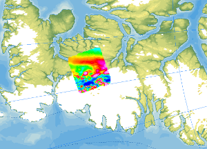
Helicopter-borne Magnetics CASE12
As part of the CASE 12 expedition, geological fieldwork and an aeromagnetic survey were conducted on Ellesmere Island (Canadian Arctic) in the summer of 2011. The helicopter-borne magnetic survey covered the ice-free areas between Vendom Fiord and Strathcona Fiord in the west and the ice-covered mountain ranges of the Inglefield Uplift in the east. With a total flight time of approx. 35 hours, 4200 line kilometres were flown covering a total area of 6000 km². The distance between the individual lines was 2 km, and control profiles perpendicular to the individual lines were flown every 10 km. The aeromagnetic data were recorded by a magnetometer, which was towed approx. 30 m beneath the helicopter.
INSPIRE
Identification
- File identifier
- 1179e1a4-d382-4385-a5cb-aac73426f25c XML
- Hierarchy level
- Dataset
Online resource
Resource identifier
- code
-
6546c4bf-d318-8ca5-e18c-876eb3f4c893
- Metadata language
- English
Encoding
- Format
-
GeoTIFF
- Version
-
n/a
- Format
-
shp
- Version
-
n/a
- Format
-
WMS
- Version
-
OGC:WMS1.3.0
Projection
- code
- EPSG:3995
Classification of data and services
- Topic category
-
- Geoscientific information
Classification of data and services
Coupled resource
Coupled resource
Classification of data and services
Coupled resource
Coupled resource
Keywords
-
GEMET - INSPIRE themes, version 1.0
-
-
Geologie
-
Geology
-
-
GEMET - Concepts, version 2.4
-
-
Geophysik
-
Other keywords
- Theme
-
-
Aerogeophysik
-
Aeromagnetik
-
Anomalien des erdmagnetischen Feldes
-
Airborne geophysics
-
helicopter-borne /fixed-wing magnetics
-
anomalies of the Earth’s magnetic field
-
- Place
-
-
Arktis
-
Arctic
-
Nordpolargebiet
-
North Polar
-
Ellesmere Island
-
Vendom Fiord
-
Geographic coverage
))
Temporal reference
Temporal extent
Temporal extent
- Date (Publication)
- 2023-02-22
Quality and validity
- Lineage
-
The aeromagnetic data were collected by BGR as part of the CASE program during the CASE 12 expedition on Ellesmere Island.
Conformity
Conformity
Conformity
Conformity
Conformity
Conformity
Restrictions on access and use
- Access constraints
- Es gelten keine Zugriffsbeschränkungen
- Access constraints
-
Allgemeine Geschäftsbedingungen, siehe https://www.bgr.bund.de/AGB - General terms and conditions, see https://www.bgr.bund.de/AGB_en . Die bereitgestellten Informationen sind bei Weiterverwendung wie folgt zu zitieren: Datenquelle: AeromagCASE12, (c) BGR, Hannover, 2023
Responsible organization (s)
Contact for the resource
- Organisation name
-
Bundesanstalt für Geowissenschaften und Rohstoffe (BGR)
Responsible organization (s)
Contact for the resource
- Organisation name
-
Bundesanstalt für Geowissenschaften und Rohstoffe (BGR)
Metadata information
Contact for the metadata
- Organisation name
-
Bundesanstalt für Geowissenschaften und Rohstoffe (BGR)
- Date stamp
- 2026-01-13
- Metadata language
- English
- Character set
- UTF8
SDS
Conformance class 1: invocable
Access Point URL
Endpoint URL
Technical specification
Conformance class 2: interoperable
Access constraints
Limitation
Use constraints
Limitation
Responsible custodian
Contact for the resource
Overviews
Spatial extent
Provided by
