 www.geodatenkatalog.de (S1L)
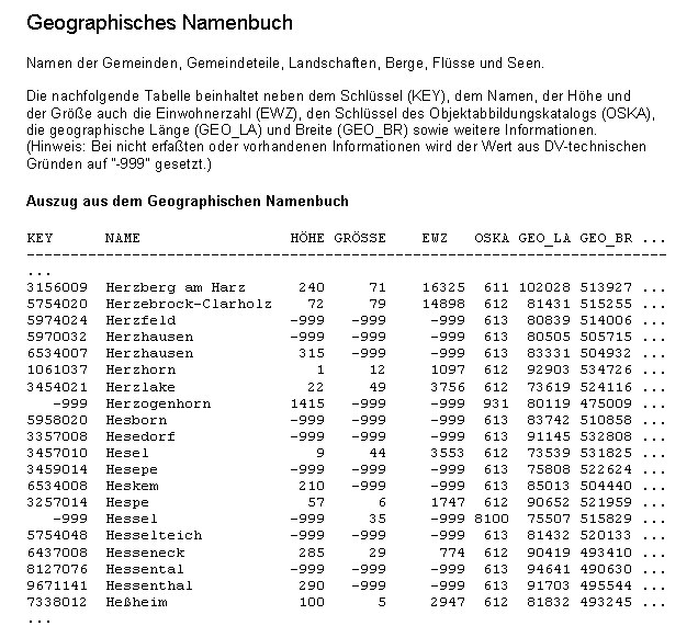
Geographische Namen 1:250 000
Die Geographischen Namen umfassen die Namen folgender Objektbereiche:
Siedlung, Verkehr, Vegetation, Gewässer, Relief, Gebiete
mit Attributen zu:
-Administrative Gliederung (statistische Schlüsselzahl)
-Flusssystem (Gewässerkennzahl nach LAWA)
-Einwohnerzahl
-Ortsvorwahl
-Größe (Fläche, Länge)
-Höhe (Höhe in Metern über NN)
-Lage (Geometriedaten aus dem Digitalen Landschaftsmodell im Maßstab 1:250 000)
-Status des geographischen Namens
-Sprache des geographischen Namens
Der Datensatz GN250 orientiert sich am Maßstab 1:250 000 und umfasst ca. 160 000 Einträge. Die Lage der Objekte wird jeweils als Punktgeometrie über eine einzelne Koordinate und über kleinste umschreibende Rechtecke (Bounding Boxes) beschrieben.
|
|
Citation proposal
. Geographische Namen 1:250 000. https://gdk.gdi-de.org/geonetwork/srv/api/records/120b660b-f5f2-4ca7-891d-2bf6b0dc309d |
INSPIRE
Identification
- File identifier
- 120b660b-f5f2-4ca7-891d-2bf6b0dc309d XML
- Hierarchy level
- dataset Dataset
Online resource
Resource identifier
- Metadata language
- German
- Metadata language
- Sorbian languages
- Metadata language
- Upper Sorbian
- Metadata language
- Lower Sorbian
- Metadata language
- Western Frisian
- Metadata language
- Danish
- Spatial representation type
- Vector
Encoding
- Format
- Shapefiles
- Version
- 1.0
- Format
- CSV
- Version
- unbekannt
Projection
Classification of data and services
- Topic category
-
- Location
Classification of data and services
Coupled resource
Coupled resource
Classification of data and services
Coupled resource
Coupled resource
Keywords
- GEMET - INSPIRE themes, version 1.0 ( Theme )
-
- Geografische Bezeichnungen
- GEMET - Concepts, version 3.1 ( Theme )
- High-value dataset categories
- High-value dataset categories
Other keywords
- Keywords
-
- Verwaltungseinheit
- Watt
- Sitz der Verwaltung
- Landgemeinde
- Teich, Stausee
- Stadt-, Landgemeindeteil
- Stadtgemeinde
- Gebirge, Hügelland
- Berg, Hügel
- Strom, Fluss
- Binnensee
- Kanal
- Keywords
-
- opendata
- Keywords
-
- AdVMIS
Geographic coverage
))
Temporal reference
Temporal extent
Temporal extent
- Date ( Creation )
- 1996-12-31T00:00:00.000+01:00
- Date ( Revision )
- 2021-12-31T00:00:00.000+01:00
Quality and validity
- Lineage
- Geographisches Namenbuch Bundesrepublik Deutschland IfaG 1981, Ergänzung 1991 bis 1996, Auswahl der Namen Übersichtskarten 1:500 000, 1:250 000, Digitales Landschaftsmodell 1:250 000
- Denominator
- 200000
- Denominator
- 300000
Conformity
Conformity
Conformity
Conformity
Conformity
Conformity
- Explanation
- see the referenced specification
- Explanation
- see the referenced specification
Restrictions on access and use
- Access constraints
- Die Daten sind urheberrechtlich geschützt. Die Daten werden geldleistungsfrei gemäß der Datenlizenz Deutschland Namensnennung 2.0 (https://www.govdata.de/dl-de/by-2-0) zur Verfügung gestellt. Die Verwendung des Datensatzes für die Pflege und Erweiterung der Daten des OpenStreetMap Projektes wird unter Einhaltung der im Ergänzungstext beschriebenen Angaben zur Namensnennung ausdrücklich erlaubt, siehe https://sgx.geodatenzentrum.de/web_public/gdz/lizenz/deu/Datenlizenz_Deutschland_Ergaenzungstext_Namensnennung.pdf. Der Quellenvermerk ist zu beachten.
- Access constraints
- Quellenvermerk: © GeoBasis-DE / BKG (Jahr des Datenbezugs)
- Access constraints
- {"id":"dl-by-de/2.0","name":"Datenlizenz Deutschland Namensnennung 2.0","url":"https://www.govdata.de/dl-de/by-2-0","quelle":"© GeoBasis-DE / BKG (Jahr des Datenbezugs)"}
Restrictions on access and use
Responsible organization (s)
Contact for the resource
- Organisation name
- Bundesamt für Kartographie und Geodäsie (BKG)
- dlz@bkg.bund.de
- Organisation name
- Bundesamt für Kartographie und Geodäsie (BKG)
- dlz@bkg.bund.de
- Organisation name
- Bundesamt für Kartographie und Geodäsie (BKG)
- mailbox@bkg.bund.de
Metadata information
Contact for the metadata
- Organisation name
- Bundesamt für Kartographie und Geodäsie (BKG)
- dlz@bkg.bund.de
- Date stamp
- 2025-10-22
- Metadata language
- German
- Character set
- UTF8
SDS
Conformance class 1: invocable
Access Point URL
Endpoint URL
Technical specification
Conformance class 2: interoperable
Coordinate reference system
Quality of Service
Access constraints
Limitation
Use constraints
Limitation
Responsible custodian
Contact for the resource
Conformance class 3: harmonized
Overviews
Provided by
