 www.geodatenkatalog.de (S1L)
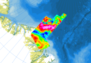
Fixed-wing Magnetics NOGRAM I + II
In 1998, as part of the expedition NOGRAM I (Northern Gravity, Radio Echo Sounding and Magnetics), a flight campaign was carried out over the Lincoln Sea north of Greenland with the Polar 2 aircraft (Dornier 228-100) in cooperation with the Alfred Wegener Institute Helmholtz Center for Polar and Marine Research. A second flight campaign NOGRAM II took place in 2011 with the Polar 5 (Basler BT-67) over the Wandel Sea north of Greenland. The aim of the research was the structure and architecture of the upper Earth’s crust underneath the ice-covered offshore areas of the Morris Jesup Plateau and coastal waters north of Greenland. The airborne magnetic surveys were carried out with a flight line spacing of 3 km, and control profiles were flown every 30 km. During the two expeditions, 33000 km of line data were collected (16000 km in 1998, and 17000 km in 2011).
|
|
Citation proposal
(2023) . Fixed-wing Magnetics NOGRAM I + II. https://gdk.gdi-de.org/geonetwork/srv/api/records/15b551ee-cfb2-4951-86a1-0c8b35b2fbf1 |
INSPIRE
Identification
- File identifier
- 15b551ee-cfb2-4951-86a1-0c8b35b2fbf1 XML
- Hierarchy level
- Dataset
Online resource
Resource identifier
- code
- 8ca95462-0160-76bf-9c5e-865b2131afaa
- Metadata language
- English
Encoding
- Format
- GeoTIFF
- Version
- n/a
- Format
- shp
- Version
- n/a
- Format
- WMS
- Version
- OGC:WMS1.3.0
Projection
Classification of data and services
- Topic category
-
- Geoscientific information
Classification of data and services
Coupled resource
Coupled resource
Classification of data and services
Coupled resource
Coupled resource
Keywords
- GEMET - INSPIRE themes, version 1.0 ( Theme )
-
- Geologie
- Geology
- GEMET - Concepts, version 2.4 ( Theme )
-
- Geophysik
Other keywords
- Keywords ( Theme )
-
- Aerogeophysik
- Aeromagnetik
- Anomalien des erdmagnetischen Feldes
- Airborne geophysics
- helicopter-borne /fixed-wing magnetics
- anomalies of the Earth’s magnetic field
- Keywords ( Place )
-
- Arktis
- Arctic
- Nordpolargebiet
- North Polar
- Grönland
- Greenland
- Lincolnsee
- Lincoln Sea
- Wandelsee
- Wandel Sea
Geographic coverage
N
S
E
W
))
Temporal reference
Temporal extent
Temporal extent
- Date ( Publication )
- 2023-02-22
Quality and validity
- Lineage
- The aeromagnetic data were collected by AWI and BGR as part of the NOGRAM I (1998 and NOGRAM II (2011) expeditions north of Greenland.
Conformity
Conformity
Conformity
Conformity
Conformity
Conformity
Restrictions on access and use
- Access constraints
- Allgemeine Geschäftsbedingungen, siehe https://www.bgr.bund.de/AGB - General terms and conditions, see https://www.bgr.bund.de/AGB_en. Die bereitgestellten Informationen sind bei Weiterverwendung wie folgt zu zitieren: Datenquelle: AeromagNOGRAM, (c) BGR, Hannover, 2023
Restrictions on access and use
Responsible organization (s)
Contact for the resource
- Organisation name
- Bundesanstalt für Geowissenschaften und Rohstoffe (BGR)
- polargeologie@bgr.de
Responsible organization (s)
Contact for the resource
- Organisation name
- Bundesanstalt für Geowissenschaften und Rohstoffe (BGR)
- polargeologie@bgr.de
Metadata information
Contact for the metadata
- Organisation name
- Bundesanstalt für Geowissenschaften und Rohstoffe (BGR)
- Date stamp
- 2025-04-07
- Metadata language
- English
- Character set
- UTF8
SDS
Conformance class 1: invocable
Access Point URL
Endpoint URL
Technical specification
Conformance class 2: interoperable
Coordinate reference system
Quality of Service
Access constraints
Limitation
Use constraints
Limitation
Responsible custodian
Contact for the resource
Conformance class 3: harmonized
Overviews
Provided by

Views
15b551ee-cfb2-4951-86a1-0c8b35b2fbf1
Access to the portal
Read here the full details and access to the data.
Associated resources
Not available