 www.geodatenkatalog.de (S3F)
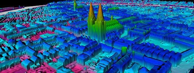
bDOM - bdom20rgbi_32_608_5931_1_sh_2021
Das bildbasierte Digitale Oberflächenmodell (bDOM) bildet die Oberfläche der Erde inklusive der auf ihr befindlichen Objekte wie Bauwerke und Vegetation mit einer Gitterweite von 20 cm ab. Das Oberflächenmodell enthält auch bewegliche Objekte, wie zum Beispiel Autos oder Flügel von Windrädern. Das bDOM wird mit einer Auflösung von 20 cm abgegeben. Die Höhengenauigkeit beträgt ± 0,5 m.
|
|
Citation proposal
(2021) . bDOM - bdom20rgbi_32_608_5931_1_sh_2021. https://gdk.gdi-de.org/geonetwork/srv/api/records/18e2bbcf-f4e0-4247-ad7b-01d6e7656814 |
- Identification
- Distribution
- Quality
- Spatial rep.
- Ref. system
- Content
- Portrayal
- Metadata
- Md. constraints
- Md. maintenance
- Schema info
Identification
Data identification
Citation
- Date ( Creation )
- 2021-05-26
- Date ( Publication )
- 2021-05-26
- Date ( Revision )
- 2021-05-26
Point of contact
Landesamt für Vermessung und Geoinformation Schleswig-Holstein
-
Vertrieb Geobasisdaten
(Servicestelle Vertrieb )
Mercatorstraße 1
Kiel
Schleswig-Holstein
24106
Deutschland
Maintenance information
- Maintenance and update frequency
- Continual
- Maintenance note
- Keywords
-
- Geobasisdaten
- Keywords
-
- bDOM
- Keywords
-
- Oberflächenmodell
- Keywords
-
- bildbasiert
- Keywords
-
- opendata
Legal constraints
- Access constraints
- Other restrictions
Legal constraints
- Use constraints
- Other restrictions
- Other constraints
- Für die Nutzung der Daten ist die Creative Commons (CC BY 4.0) – Namensnennung 4.0 International anzuwenden. Die Lizenz ist über http://creativecommons.org/licenses/by/4.0 abrufbar. Der Quellenvermerk lautet "© GeoBasis-DE/LVermGeo SH/CC BY 4.0"
- Other constraints
- {"id":"cc-by/4.0","name":"Creative Commons Namensnennung – 4.0 International (CC BY 4.0)","url":"http://creativecommons.org/licenses/by/4.0/","quelle":"© GeoBasis-DE/LVermGeo SH/CC BY 4.0"}
- Spatial representation type
- Grid
- Metadata language
- Deutsch German
- Character set
- UTF8
- Topic category
-
- Imagery base maps earth cover
N
S
E
W
))
Distribution
Distribution
- Distribution format
-
- LAS/LAZ, Tiff (keine Angabe )
Point of contact
Landesamt für Vermessung und Geoinformation Schleswig-Holstein
-
Vertrieb Geobasisdaten
Mercatorstraße 1
Kiel
Schleswig-Holstein
24106
Deutschland
Quality
Data quality
Scope
- Hierarchy level
- Tile
- Statement
- Vollautomatische Ableitung aus digitalen Luftbildern.
Metadata
Metadata
- File identifier
- 18e2bbcf-f4e0-4247-ad7b-01d6e7656814 XML
- Metadata language
- German
- Character set
- UTF8
- Parent identifier
- 712bf80c-f673-477d-a27a-68438c79ead2
- Hierarchy level
- Tile
- Hierarchy level name
- Schleswig-Holstein
- Date stamp
- 2023-11-21
Point of contact
Landesamt für Vermessung und Geoinformation Schleswig-Holstein
-
Servicestelle Metadaten
Mercatorstraße 1
Kiel
Schleswig-Holstein
24106
Deutschland
Overviews
Provided by

Views
18e2bbcf-f4e0-4247-ad7b-01d6e7656814
Access to the portal
Read here the full details and access to the data.
Associated resources
Not available