 My GeoNetwork catalogue
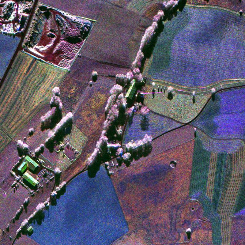
F-SAR - RGI/GTC/INF
F-SAR, “Flugzeug-SAR”, is an airborne high-resolution imaging radar (Synthetic Aperture Radar) sensor presently operated by the German Aerospace Center (DLR), Microwaves and Radar Institute (HR) since November 02, 2006. It is operated on a Dornier Do-228 aircraft from altitudes of 2000 to 6000 m above ground in five different center frequency bands (X,C,S,L,P). Wavelengths range from 3 cm, 5 cm, 9 cm, 23 cm to 67 cm. Ka-band (1 cm wavelength) is planned to be added. Up to four center-frequencies (X,S,L,P) or (X,C,L,P) can be operated simultaneously per overflight. All frequencies are fully polarimetric (HH,HV,VV,VH) and have full repeat-pass capabilities. Single-pass interferometry in along-track (ATI) and across-track mode is available in X-band (ATI and/or XTI) and S-band (XTI). Data are processed up to three different levels: RGI (Radar Geometry Image product), INF (Repeat-pass-interferometric product) and GTC (Geocoded and Terrain-Corrected product). Resolutions range from 25 cm (X-band) to 1.5 m (P-band) in both azimuth and range direction. Data acquisition modes are typically “stripmap”, “repeat-pass” (two parallel tracks), “tomography” (several parallel tracks), ”circular” (one circle) or “circular-tomography” (several vertically distributed circles). Individually planned experiments can also be supported.
For more information concerning F-SAR data, the reader is referred to: www.dlr.de/hr/f-sar
INSPIRE
Identification
- File identifier
- 19bececb-bb85-4641-bdd4-d30ac1bbd406 XML
- Hierarchy level
- Series
Online resource
- Protocol
-
WWW:LINK-1.0-http--link
- Protocol
-
WWW:LINK-1.0-http--link
- Protocol
-
WWW:LINK-1.0-http--link
- Protocol
-
WWW:LINK-1.0-http--link
Resource identifier
- Metadata language
- English
- Spatial representation type
- Grid
Encoding
Projection
- code
-
UTM/WGS84
Classification of data and services
- Topic category
-
- Imagery base maps earth cover
Classification of data and services
Coupled resource
Coupled resource
Classification of data and services
Coupled resource
Coupled resource
Keywords
-
GEMET - INSPIRE themes, version 1.0
-
-
Orthoimagery
-
Other keywords
- Keywords
-
-
urn:eop:DLR:EOWEB:AIRRS.F-SAR
-
F-SAR
-
airborne earth observation
-
SAR
-
RGI, GTC, INF
-
multi-frequency
-
fully-polarimetric
-
circular
-
holographic SAR tomography
-
stripmap
-
Geographic coverage
))
Temporal reference
Temporal extent
Temporal extent
- Date (Creation)
- 2019-05-08T16:24:43
Quality and validity
- Lineage
-
The RGI products are derived from RAW data acquired by the SAR sensor. INF and GTC products are based on the respective RGI product. All data processing is performed by DLR-HR proprietary software, i.e. the SAR Technology Experimental Processor STEP. SAR data are calibrated and motion compensated based on precise antenna measurements from DLR-HR’s CTR facility using as input also DEM information.
- Denominator
- 500
Conformity
Conformity
Conformity
Conformity
Conformity
Conformity
- Explanation
-
See the referenced specification
Restrictions on access and use
- Access constraints
- Public access to spatial data sets and services would adversely affect intellectual property rights.
- Access constraints
-
Nutzungsbedingungen: Lizenz / Terms of Use: License; Data available after successful proposal evaluation (contact: airborne-sar@dlr.de )
Responsible organization (s)
Contact for the resource
- Organisation name
-
German Aerospace Center (DLR)
- Organisation name
-
German Aerospace Center (DLR)
- Organisation name
-
German Aerospace Center (DLR)
Responsible organization (s)
Contact for the resource
- Organisation name
-
German Aerospace Center (DLR)
- Organisation name
-
German Aerospace Center (DLR)
- Organisation name
-
German Aerospace Center (DLR)
Metadata information
Contact for the metadata
- Organisation name
-
German Aerospace Center (DLR)
- Date stamp
- 2024-06-20T13:07:10
- Metadata language
- English
- Character set
- UTF8
SDS
Conformance class 1: invocable
Access Point URL
Endpoint URL
Technical specification
Conformance class 2: interoperable
Access constraints
Limitation
Use constraints
Limitation
Responsible custodian
Contact for the resource
Overviews

Spatial extent
Provided by
