 www.geodatenkatalog.de (S2L)
The 1:5 Million International Geological Map of Europe and Adjacent Areas - German part (WMS)
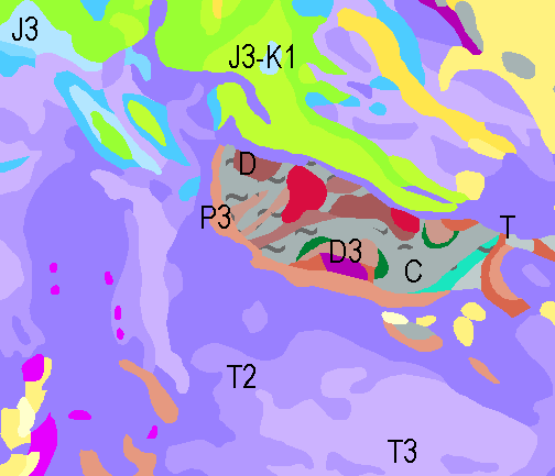
The 1:5 Million International Geological Map of Europe and Adjacent Areas shows the pre-Quaternary geology of Europe onshore and offshore. In addition to the geology attributed by age, petrography and genesis, also magnetic anomalies, tectonic structures, metamorphism and – in the offshore areas – information about the continental/oceanic crust and the continental margin, are shown. The map was developed by BGR under the umbrella of the Commission of the Geological Map of the World (CGMW) and in cooperation with geological surveys organisations of 48 countries and more than 20 research institutes. For detailed information about the 'IGME 5000: More than just a map – A multinational GIS Project' please visit the IGME website. Corresponding to the INSPIRE-directive, this dataset comprises the German part of the map.
|
|
Citation proposal
Bundesanstalt für Geowissenschaften und Rohstoffe (BGR). The 1:5 Million International Geological Map of Europe and Adjacent Areas - German part (WMS). https://gdk.gdi-de.org/geonetwork/srv/api/records/19f4a2ac-1063-4119-83cf-19e7bb6033c0 |
INSPIRE
Identification
- File identifier
- 19f4a2ac-1063-4119-83cf-19e7bb6033c0 XML
- Hierarchy level
- Service
Online resource
Resource identifier
Encoding
- Format
- png
- Version
- n/a
- Format
- jpeg
- Version
- n/a
- Format
- gif
- Version
- n/a
Projection
Classification of data and services
Classification of data and services
- Service Type
- view
- Coupling Type
- Tight
Coupled resource
Coupled resource
Classification of data and services
- Service Type
- view
- Coupling Type
- Tight
Coupled resource
Coupled resource
Keywords
- GEMET - INSPIRE themes, version 1.0 ( Theme )
-
- Geologie
- Geology
- Spatial scope
-
- National
Other keywords
- Keywords ( Theme )
-
- infoMapAccessService
- opendata
- GeolDG
- Keywords ( Place )
-
- Deutschland
Geographic coverage
N
S
E
W
))
Temporal reference
Temporal extent
Temporal extent
- Date ( Creation )
- 2015-08-31
Quality and validity
- Lineage
- Die Karte entstand unter der Leitung der BGR und der Schirmherrschaft der Kommission der Geologischen Karte der Welt (Weltkartenkommission, CGMW) mit Beiträgen von 48 europäischen geologischen Diensten und mehr als 20 wissenschaftlichen Institutionen. - The map was compiled by BGR with contributions of 48 national geological survey organisations in Europe and adjacent areas and around 20 scientific institutes.
Conformity
Conformity
Conformity
Conformity
Conformity
Conformity
Restrictions on access and use
Restrictions on access and use
- Access constraints
- Allgemeine Geschäftsbedingungen, siehe https://www.bgr.bund.de/AGB - General terms and conditions, see https://www.bgr.bund.de/AGB_en. Die bereitgestellten Informationen sind bei Weiterverwendung wie folgt zu zitieren: Datenquelle: IGME5000-DE, (c) BGR, Hannover, 2015.
- Access constraints
- Dieser Datensatz kann gemäß der "Nutzungsbestimmungen für die Bereitstellung von Geodaten des Bundes" (https://sg.geodatenzentrum.de/web_public/gdz/lizenz/geonutzv.pdf) genutzt werden.
- Access constraints
- Dieser Datensatz kann gemäß der "Nutzungsbestimmungen für die Bereitstellung von Geodaten des Bundes" (https://sg.geodatenzentrum.de/web_public/gdz/lizenz/geonutzv.pdf) genutzt werden.
Responsible organization (s)
Contact for the resource
- Organisation name
- Bundesanstalt für Geowissenschaften und Rohstoffe (BGR)
- geologie.daten@bgr.de
- Organisation name
- Bundesanstalt für Geowissenschaften und Rohstoffe (BGR)
Responsible organization (s)
Contact for the resource
- Organisation name
- Bundesanstalt für Geowissenschaften und Rohstoffe (BGR)
- geologie.daten@bgr.de
- Organisation name
- Bundesanstalt für Geowissenschaften und Rohstoffe (BGR)
Metadata information
Contact for the metadata
- Organisation name
- Bundesanstalt für Geowissenschaften und Rohstoffe (BGR)
- Date stamp
- 2024-03-04
- Metadata language
- German
SDS
Conformance class 1: invocable
Access Point URL
Endpoint URL
Technical specification
- Date
- Explanation
- siehe dazu die angegebene Durchführungsbestimmung
Conformance class 2: interoperable
Coordinate reference system
Quality of Service
Access constraints
- Access constraints
- Other restrictions
Limitation
Use constraints
Limitation
- string
- Allgemeine Geschäftsbedingungen, siehe https://www.bgr.bund.de/AGB - General terms and conditions, see https://www.bgr.bund.de/AGB_en. Die bereitgestellten Informationen sind bei Weiterverwendung wie folgt zu zitieren: Datenquelle: IGME5000-DE, (c) BGR, Hannover, 2015.
- string
- Dieser Datensatz kann gemäß der "Nutzungsbestimmungen für die Bereitstellung von Geodaten des Bundes" (https://sg.geodatenzentrum.de/web_public/gdz/lizenz/geonutzv.pdf) genutzt werden.
- string
- Dieser Datensatz kann gemäß der "Nutzungsbestimmungen für die Bereitstellung von Geodaten des Bundes" (https://sg.geodatenzentrum.de/web_public/gdz/lizenz/geonutzv.pdf) genutzt werden.
Responsible custodian
Contact for the resource
- Organisation name
- Bundesanstalt für Geowissenschaften und Rohstoffe (BGR)
Conformance class 3: harmonized
Contains Operations
- Operation Name
- GetCapabilities
- Distributed Computing Platforms
- Web services
- Connect Point
- https://services.bgr.de/wms/geologie/igme5000de/?
Contains Operations
- Operation Name
- GetMap
- Distributed Computing Platforms
- Web services
- Connect Point
- https://services.bgr.de/wms/geologie/igme5000de/?
Overviews
Provided by

Views
19f4a2ac-1063-4119-83cf-19e7bb6033c0
Access to the portal
Read here the full details and access to the data.
Associated resources
Not available