 My GeoNetwork catalogue
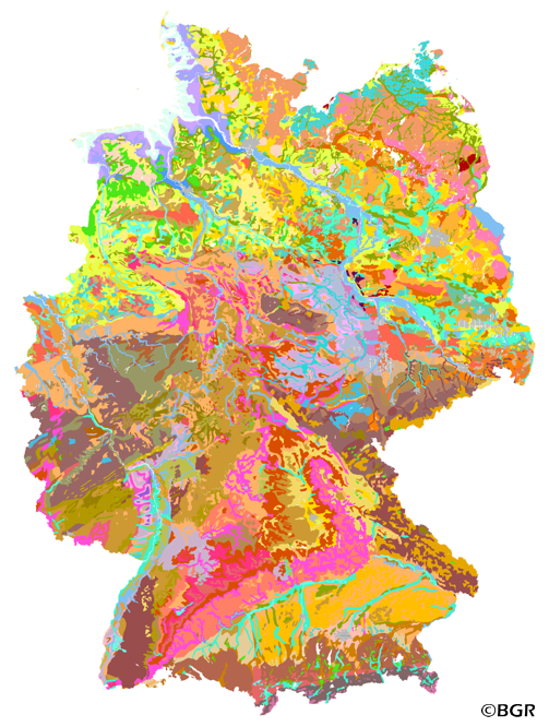
Soil Map of the Federal Republic of Germany 1:1,000,000 (BUEK1000EN)
The first country wide soil map at a scale of 1:1,000,000 (BUEK1000) has been compiled on the basis of published soil maps of the former German Democratic Republic and the pre 1990 federal states of Germany. To do this, it was necessary to match the soil systems used in East and West Germany and to develop standardized descriptions of soil units. A relatively homogeneous map has resulted, which permits uniform assessment of the soils throughout Germany. The map shows 71 soil mapping units, described in the legend on the basis of the German and FAO soil systems. Each soil unit has been assigned a characteristic soil profile (Leitprofil) as an aid to map interpretation. For the first time the subdivision of the country into 12 soil regions has been represented on the map. This subdivision was coordinated with the state Geological Surveys. These soil regions will represent the highest hierarchic level of nation wide soil maps in future. The colours of soil units correspond to the standards of the 'Bodenkundliche Kartieranleitung' (KA 3; Guidelines for Soil Mapping). The various hues characterize differences in relief or soil humidity. The BUEK1000 was produced digitally. It is an important part of the spatial database integrated in the Soil Information System currently being established at the Federal Institute for Geosciences and Natural Resources (FISBo BGR). It can be used together with the characteristic soil profiles to derive thematic maps related to nation wide soil protection. The scale of the BUEK1000 makes it especially suitable for small scale evaluations at federal or EU level.
Simple
- Alternate title
-
BUEK1000EN
- Date (Creation)
- 1994-07-01
- Date (Publication)
- 2013-12-12
- Edition
-
Version 2.1
- Citation identifier
- E44D2386-0B71-4862-BC1F-4FA7692057F5
- Status
- Completed
-
GEMET - INSPIRE themes, version 1.0
-
-
Boden
-
Soil
-
-
GEMET - Concepts, version 2.4
-
-
Bodenart
-
Bodenauslaugung
-
Bodenbearbeitung
-
Bodenbelastung
-
Bodenbildung
-
Bodenbiologie
-
Bodenchemie
-
Bodendegradation
-
Bodendekontamination
-
Bodenerosion
-
Bodenfeuchtigkeit
-
Bodenfruchtbarkeit
-
Bodenfunktion
-
Bodengestaltung
-
Bodengüte
-
Bodenkarte
-
Bodenluft
-
Bodenmechanik
-
Bodenmineralogie
-
Bodennutzbarkeit
-
Bodennutzung
-
-
SGD-Liste
-
-
Bodeneigenschaften
-
Bodengefüge
-
Bodengruppe
-
Bodenhorizont
-
bodenphysikalische Eigenschaften
-
Bodenskelett
-
Bodenverbreitung
-
Durchlässigkeit
-
effektive Durchwurzelungstiefe
-
-
Freies Schlagwort
-
-
environmental protection
-
geographical information system
-
parent material
-
parent rock
-
soil association
-
soil complex
-
soil information system
-
soil map
-
soil polygon
-
soil profile
-
soil property
-
soil protection
-
soil science
-
soil substrate
-
soil systematics
-
soil textural class
-
soil type
-
- Place
-
-
Federal Republic of Germany
-
- Access constraints
- Other restrictions
- Other constraints
- Es gelten keine Zugriffsbeschränkungen
- Use constraints
- Other restrictions
- Other constraints
-
General Standard Terms and Conditions (GSTC) of the Federal Institute for Geosciences and Natural Resources. The information made available shall be quotet as follows in case of reuse: Datasource: BUEK1000 V2.1, (C) BGR, Hannover, 2013.
- Spatial representation type
- Vector
- Denominator
- 1000000
- Language
- English
- Character set
- UTF8
- Topic category
-
- Geoscientific information
))
- Geographic identifier
- Regionalschlüssel / 000000000000
- Unique resource identifier
- EPSG:3034
- Distribution format
-
-
PDF
(
n/a
)
-
Shapefile
(
n/a
)
-
PNG
(
n/a
)
-
TIFF
(
n/a
)
-
PDF
(
n/a
)
- Transfer size
- 11
- OnLine resource
-
BUEK1000EN (PDF)
BUEK1000EN im Format Adobe Acrobat Datei (Auflösung 600 dpi)
- Transfer size
- 9
- OnLine resource
-
BUEK1000EN (Shapefile)
BUEK1000EN im Format ESRI Shape
- Transfer size
- 23
- OnLine resource
-
BUEK1000EN (PNG)
BUEK1000EN im Format PNG (Auflösung 150 dpi)
- Transfer size
- 30
- OnLine resource
-
BUEK1000EN (TIFF)
BUEK1000EN im Format TIFF (Auflösung 300 dpi)
- OnLine resource
- Webseite des Kartenwerks - Website of the map
- Hierarchy level
- Dataset
- Statement
-
BGR (BÜK1000, 0.1), Forstplanungsämter und Staatliche Geologische Dienste der Länder 1994.
- File identifier
- 1AA9B216-33F8-48F5-850F-8C6A4E6978AC XML
- Metadata language
- English
- Character set
- UTF8
- Hierarchy level
- Dataset
- Hierarchy level name
-
Boden
- Date stamp
- 2026-03-03
- Metadata standard name
-
INSPIRE Metadata Implementing Rules: Technical Guidelines based on EN ISO 19115 and EN ISO 19119
- Metadata standard version
-
n/a
Overviews
Spatial extent
Provided by
