 www.geodatenkatalog.de (S3L)
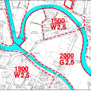
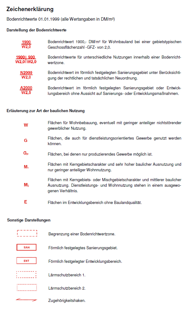
Bodenrichtwerte 01.01.1999
Bodenrichtwertatlas basierend auf den Rasterdaten des Gutachterausschusses für Grundstückswerte in Berlin vom 01.01.1999. Die Bodenrichtwerte sind in DM/m² angegeben!
|
|
Citation proposal
(1999) . Bodenrichtwerte 01.01.1999. https://gdk.gdi-de.org/geonetwork/srv/api/records/1acadb93-23c1-3469-a58f-79304c82e71f |
Simple
Identification info
- Date ( Creation )
- 1999-01-01
- Date ( Publication )
- 1999-02-23
- Date ( Revision )
- 1999-05-06
- Presentation form
- Digital map
Point of contact
- Maintenance and update frequency
- As needed
- Keywords ( Theme )
-
- open data
- opendata
- Karten
- Geodaten
- Berlin
- Werte
- Preise
- Wertermittlung
- Gutachterausschuss
- Bodenrichtwertatlas
- Grundstück
- GAA
- Bodenrichtwerte
- Räumlicher Anwendungsbereich ( Theme )
- Keywords
-
- infoMapAccessService
- Access constraints
- Other restrictions
- Use constraints
- Other restrictions
- Other constraints
- Für die Nutzung der Daten ist die Datenlizenz Deutschland - Zero - Version 2.0 anzuwenden. Die Lizenz ist über https://www.govdata.de/dl-de/zero-2-0 abrufbar.
- Other constraints
- {"id":"dl-zero-de/2.0","name":"Datenlizenz Deutschland - Zero - Version 2.0","url":"https://www.govdata.de/dl-de/zero-2-0"}
- Service Type
- view
- Service Version
- OGC:WMS 1.0.0
- Service Version
- OGC:WMS 1.1.0
- Service Version
- OGC:WMS 1.1.1
- Service Version
- OGC:WMS 1.3.0
N
S
E
W
))
- Extent type code
- true
- Geographic identifier
- 110000000000
- Coupling Type
- Tight
Contains Operations
- Operation Name
- GetCapabilities
- Distributed Computing Platforms
- Web services
- Connect Point
- https://gdi.berlin.de/services/wms/brw1999
- Operates On
- Reference system identifier
- http://www.opengis.net/def/crs/EPSG/0/25833
- Distribution format
-
-
Text/HTML
(4.01 )
- Specification
- Keine Angabe
-
Text/HTML
(4.01 )
- OnLine resource
-
Darstellungsdienst - Bodenrichtwerte 01.01.1999 (WMS)
Darstellungsdienst - Bodenrichtwerte 01.01.1999 (WMS)
- OnLine resource
-
Darstellung der Karte im Geoportal Berlin
Darstellung der Karte im Geoportal Berlin
- Hierarchy level
- Service
- Other
- Dienst
gmd:MD_Metadata
- File identifier
- 1acadb93-23c1-3469-a58f-79304c82e71f XML
- Metadata language
- German
- Character set
- UTF8
- Hierarchy level
- Service
- Hierarchy level name
- Bodenrichtwerte 01.01.1999 Dienst
- Date stamp
- 2025-11-19T00:00:00Z
- Metadata standard name
- ISO 19115/19119 - BE
- Metadata standard version
- 1.0.0
Point of contact
Overviews
Vorschaubild
Legende
Provided by

Views
1acadb93-23c1-3469-a58f-79304c82e71f
Access to the portal
Read here the full details and access to the data.
Associated resources
Not available