 www.geodatenkatalog.de (S3L)
Gebäudehöhen (Umweltatlas)
Der Datensatz stellt die Gebäudehöhen (Firsthöhen) auf der Grundlage der dreidimensionalen Gebäudemodelle des Landes Berlin im Level of Detail 2 (LoD2) dar. Die Grundrisse der Gebäude entsprechen genau den Gebäudeumringen, wie sie im Liegenschaftskataster ALKIS nachgewiesen sind. Für die Dachformen werden in den Attributen Angaben zur generalisierten Standarddachform angegeben. Die Daten werden computergestützt automatisiert berechnet. Für einzelne Gebäude konnte keine Höhe ermittelt werden.
|
|
Citation proposal
(2022) . Gebäudehöhen (Umweltatlas). https://gdk.gdi-de.org/geonetwork/srv/api/records/1c1554aa-bffa-3e37-90bd-5f971e46ab88 |
INSPIRE
Identification
- File identifier
- 1c1554aa-bffa-3e37-90bd-5f971e46ab88 XML
- Hierarchy level
- Service
Online resource
Resource identifier
Encoding
- Format
- Text/HTML
- Version
- 4.01
- Specification
- Keine Angabe
Projection
Classification of data and services
Classification of data and services
- Service Type
- view
- Coupling Type
- Tight
Coupled resource
Coupled resource
Classification of data and services
- Service Type
- view
- Coupling Type
- Tight
Coupled resource
Coupled resource
Keywords
- Räumlicher Anwendungsbereich ( Theme )
Other keywords
- Keywords ( Theme )
-
- open data
- opendata
- Karten
- Sachdaten
- Geodaten
- Berlin
- Umweltatlas
- Gebäudehöhen
- Bauwerke
- LoD2
- Gebäudemodell
- 3D
- ALKIS
- Liegenschaftskataster
- Keywords
-
- infoMapAccessService
Geographic coverage
N
S
E
W
))
Temporal reference
Temporal extent
Temporal extent
- Date ( Publication )
- 2022-04-06
- Date ( Revision )
- 2023-08-23
Quality and validity
Conformity
Conformity
Conformity
Conformity
Conformity
Conformity
Restrictions on access and use
Restrictions on access and use
- Access constraints
- Für die Nutzung der Daten ist die Datenlizenz Deutschland - Zero - Version 2.0 anzuwenden. Die Lizenz ist über https://www.govdata.de/dl-de/zero-2-0 abrufbar.
- Access constraints
- {"id":"dl-zero-de/2.0","name":"Datenlizenz Deutschland - Zero - Version 2.0","url":"https://www.govdata.de/dl-de/zero-2-0"}
Responsible organization (s)
Contact for the resource
- Organisation name
- Senatsverwaltung für Stadtentwicklung, Bauen und Wohnen Berlin
- Organisation name
- Senatsverwaltung für Stadtentwicklung, Bauen und Wohnen Berlin
Responsible organization (s)
Contact for the resource
- Organisation name
- Senatsverwaltung für Stadtentwicklung, Bauen und Wohnen Berlin
- Organisation name
- Senatsverwaltung für Stadtentwicklung, Bauen und Wohnen Berlin
Metadata information
Contact for the metadata
- Organisation name
- Senatsverwaltung für Stadtentwicklung, Bauen und Wohnen Berlin
- Date stamp
- 2025-11-19T00:00:00Z
- Metadata language
- German
SDS
Conformance class 1: invocable
Access Point URL
Endpoint URL
Technical specification
Conformance class 2: interoperable
Coordinate reference system
Quality of Service
Access constraints
- Access constraints
- Other restrictions
Limitation
Use constraints
Limitation
- string
- Für die Nutzung der Daten ist die Datenlizenz Deutschland - Zero - Version 2.0 anzuwenden. Die Lizenz ist über https://www.govdata.de/dl-de/zero-2-0 abrufbar.
- string
- {"id":"dl-zero-de/2.0","name":"Datenlizenz Deutschland - Zero - Version 2.0","url":"https://www.govdata.de/dl-de/zero-2-0"}
Responsible custodian
Contact for the resource
Conformance class 3: harmonized
Contains Operations
- Operation Name
- GetCapabilities
- Distributed Computing Platforms
- Web services
- Connect Point
- https://gdi.berlin.de/services/wms/ua_gebaeudehoehen
Overviews
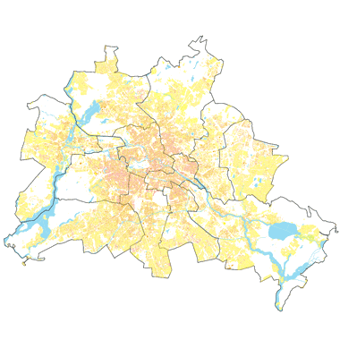
Vorschaubild
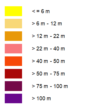
Legende
Provided by

Views
1c1554aa-bffa-3e37-90bd-5f971e46ab88
Access to the portal
Read here the full details and access to the data.
Associated resources
Not available