 www.geodatenkatalog.de (S2L)
WMTS Digitale Topographische Landeskarte 1 : 250 000 Brandenburg mit Berlin
Dieser Web Map Tile Service stellt das Kartenbild der Landeskarte 1 : 250 000 vom Gebiet Brandenburg/Berlin zur Verfügung.
|
|
Citation proposal
(2008) . WMTS Digitale Topographische Landeskarte 1 : 250 000 Brandenburg mit Berlin. https://gdk.gdi-de.org/geonetwork/srv/api/records/1c6683ce-bc82-4fdb-bf26-6e18e7008a1d |
INSPIRE
Identification
- File identifier
- 1c6683ce-bc82-4fdb-bf26-6e18e7008a1d XML
- Hierarchy level
- service Service
Online resource
Resource identifier
Encoding
Projection
Classification of data and services
Classification of data and services
- Service Type
- view
- Coupling Type
- tight Tight
Coupled resource
Coupled resource
Classification of data and services
- Service Type
- view
- Coupling Type
- tight Tight
Coupled resource
Coupled resource
Keywords
Other keywords
- Keywords
-
- opendata
- Keywords ( Theme )
-
- AdV-OWS-Basisprofil
- Geobasisdaten
- WMTS
- AdVMIS
- bboxbebb
- WMTS_BB-BE_LK250
- BB-BE
- LK
- Navigation
- Landeskarte
- infoMapAccessService
- Keywords ( Place )
-
- Brandenburg
- Berlin
Geographic coverage
N
S
E
W
))
Temporal reference
Temporal extent
Temporal extent
- Date ( Publication )
- 2008-11-04T00:00:00
- Date ( Revision )
- 2019-08-14T00:00:00
Quality and validity
Conformity
Conformity
Conformity
Conformity
Conformity
Conformity
Restrictions on access and use
Restrictions on access and use
- Access constraints
- Die Daten können gemäß der „Datenlizenz Deutschland - Namensnennung - Version 2.0“ (https://www.govdata.de/dl-de/by-2-0) genutzt werden. Namensnennung: "GeoBasis-DE/LGB", Beispiel: „© GeoBasis-DE/LGB, dl-de/by-2-0, (Daten geändert)“, (Klammer = optional)
- Access constraints
- {"id":"dl-by-de/2.0","name":"Datenlizenz Deutschland - Namensnennung - Version 2.0","url":"https://www.govdata.de/dl-de/by-2-0","quelle":"Quelle: © GeoBasis-DE/LGB, dl-de/by-2-0"}
Responsible organization (s)
Contact for the resource
- Organisation name
- Landesvermessung und Geobasisinformation Brandenburg (LGB)
Responsible organization (s)
Contact for the resource
- Organisation name
- Landesvermessung und Geobasisinformation Brandenburg (LGB)
Metadata information
Contact for the metadata
- Organisation name
- Landesvermessung und Geobasisinformation Brandenburg (LGB)
- Date stamp
- 2025-04-04T09:22:57
- Metadata language
- ger German
SDS
Conformance class 1: invocable
Access Point URL
Endpoint URL
Technical specification
Conformance class 2: interoperable
Coordinate reference system
Quality of Service
Access constraints
- Access constraints
- Other restrictions
Limitation
Use constraints
Limitation
- string
- Die Daten können gemäß der „Datenlizenz Deutschland - Namensnennung - Version 2.0“ (https://www.govdata.de/dl-de/by-2-0) genutzt werden. Namensnennung: "GeoBasis-DE/LGB", Beispiel: „© GeoBasis-DE/LGB, dl-de/by-2-0, (Daten geändert)“, (Klammer = optional)
- string
- {"id":"dl-by-de/2.0","name":"Datenlizenz Deutschland - Namensnennung - Version 2.0","url":"https://www.govdata.de/dl-de/by-2-0","quelle":"Quelle: © GeoBasis-DE/LGB, dl-de/by-2-0"}
Responsible custodian
Contact for the resource
Conformance class 3: harmonized
Contains Operations
- Operation Name
- GetTile
- Distributed Computing Platforms
- Web services
- Connect Point
- https://isk.geobasis-bb.de/mapproxy/lk250_wmts/service?
Contains Operations
- Operation Name
- GetCapabilities
- Distributed Computing Platforms
- Web services
- Connect Point
- https://isk.geobasis-bb.de/mapproxy/lk250_wmts/service?
Overviews
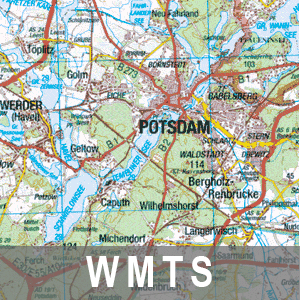
Vorschaubild: LK250
Provided by

Views
1c6683ce-bc82-4fdb-bf26-6e18e7008a1d
Access to the portal
Read here the full details and access to the data.
Associated resources
Not available