 www.geodatenkatalog.de (S3L)
Processed seismic data of Cruise BGR04 ARGURU 2004
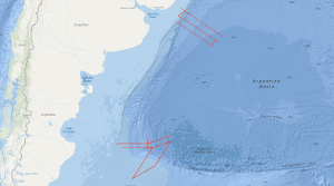
From 19th November to 19th December 2004 BGR conducted a marine geophysical cruise between 34°S and 36°S off Uruguay and between 46°S and 50°S off Argentine. The main research objective was to contribute to a better understanding of the initial breakup and the early opening of the South Atlantic. In continuation of our former work on the South Atlantic continental margins off Argentina, Brazil, Uruguay, Namibia and South Africa marine geophysical research (multi-channel seismics, refraction-/wide-angle reflection seismics, magnetics and gravity) was performed in close cooperation with the Argentine and Uruguayan authorities Comisión Nacional del Límite Exterior de la Plataforma Continental (COPLA) of Argentina and Servicio de Oceanograficia, Hidrograficia y Meteorologia de la Armada (SOHMA) of Uruguay. Multi-channel seismic lines with a total length of 3,754 km and additional 3540 km with the other geophysical methods were acquired . Along two lines refraction-/wide-angle reflection seismic work was carried out. The preliminary analyses of the new seismic data show different images of the crustal structures between Uruguay and southern Argentine with regard to the distribution and volume of offshore volcanic rocks (seaward dipping reflector sequences, SDRS) along the South American Atlantic margin. On the northern profiles between 34°S and 36°S one single well developed wedge of SDRS is present. Although the landward termination (‘feather edge’) on most of the lines is masked by multiples the average total width of the wedge across the margin seems to be 90 – 100 km and is very constant for this margin segment. This is strong contrast to the results from former cruises (BGR87, SO85 and BGR98) which covered the area between 38°S and 45°S. There, the SDRS showed distinct multiple wedges which in some places extend over 120 km across the continental slope. The investigation of the sedimentary section yielded that in the area off Uruguay widespread bottom simulating reflectors (BSR) are present. This indications for stable gas hydrates cover a total area of 7000 km2. One major aim of the cruise was to cover the transition between a volcanic passive margin and a non-volcanic passive resp. sheared margin. This was accomplished in the southern part of the investigated area. Two EW-trending profiles across the Argentine shelf into the Argentine Basin still show indications for SDRS but these structures are only 25 – 30 km wide. The profiles which extend from the NE to the SW crossing the Agulhas-Falkland Fracture Zone (AFFZ) onto the Falkland Plateau show the typical trend of a sheared margin. At the northern rim of the Falkland Plateau a set of small pre-rift half grabens were found indicating pre-rift extensional tectonic phases. The magnetic data in the area off Uruguay show lineations which are preliminary interpreted as chrons M0 to M3. This might indicate that the first (oldest) oceanic crust was created at a time around the magnetic polarity reversal between the normal interval M4 and the reversed interval M3 (126-127 Ma). Together with existing data from previous cruises this indicates that the breakup of the South Atlantic started further South because there magnetic chrons back to M9 (130 Ma) were identified. In the southernmost part of the margin at 47°S only the magnetic lineations M0 to M4 were identified in the oceanic domain Nevertheless, it is likely that between M4 and the assumed position of the continent ocean boundary/transition (COB/COT) older oceanic crust exists that for some reasons does not show correlatable lineations. The the free-air gravity map is dominated by the main topographic and structural features in the survey area. Rifted continental margins are characterized by prominent free-air gravity anomalies elongated parallel to the ocean-continent transition. The continental slope is considerably steeper in the North off Uruguay than in the South and thus the gravity high is much more pronounced in the North than in the South. The simple Bouguer anomaly map also shows the difference between the more gentle and wider continental slope in the South and the steeper slope in the North. The lowest Bouguer gravity values are found in the area of the basins on the continental shelf. Especially the Salado Basin in the prolongation of the Rio de la Plata and the Colorado Basin at about 40°S are indicated by Bouguer gravity anomaly highs. The interpretation by forward density modelling shows, however, the presence of SDRS units in the North of relative high density in the area of the continental slope. Whereas the modelling shows no indications for such volcanic bodies in the South. Although the MCS data indicate a small SDRS wedge but this body may be too small to cause an anomaly.From 17th April to 6th June 2003 BGR conducted a marine geophysical cruise between 30°S and 38°S off the Atlantic coast of South Africa. The main research objective was to contribute to a better understanding of the initial breakup and the early opening of the South Atlantic. In continuation of our former work on the South Atlantic continental margins off Argentina, Brazil, Uruguay and Namibia marine geophysical research (multi-channel seismics, wide-angle refraction seismics, magnetics and gravity) was performed in cooperation with the Petroleum Agency South Africa (PASA). Multi-channel lines with a total lenght of 3,260 km, and additional 1,365km, with the other geophysical methods were acquired. Combined onshore/offshore refraction seismic work in cooperation with GeoForschungsZentrum Potsdam (Germany) and the Council for Geoscience (South Africa) was also part of the program.
|
|
Citation proposal
. Processed seismic data of Cruise BGR04 ARGURU 2004. https://gdk.gdi-de.org/geonetwork/srv/api/records/1d19a692-8a84-4434-91e9-b9bc8bc37623 |
Simple
- Alternate title
- BGR04 ARGURU 2004
- Date ( Creation )
- 2004-12-19
- Identifier
- 67a00038-5db8-adbe-81c7-28a83feabf77
- Status
- completed Completed
Point of contact
- GEMET - INSPIRE themes, version 1.0 ( Theme )
-
- Geologie
- geology
- GEMET - Concepts, version 2.4 ( Theme )
-
- geophysics
- Geophysik
- raw material
- Rohstoff
- Keywords ( Theme )
-
- Marine geology
- Meeresgeologie
- Seismics
- Seismik
- Two-dimensional seismic reflection
- zweidimensionale Reflektionsseismik
- Keywords ( Place )
-
- Southwest Atlantic Ocean
- Südwestatlantik
- Uruguay
- Argentinien
- Argentina
- Access constraints
- Other restrictions
- Use constraints
- Other restrictions
- Other constraints
- Allgemeine Geschäftsbedingungen, siehe http://www.bgr.bund.de/AGB - General terms and conditions, see http://www.bgr.bund.de/AGB_en. Die bereitgestellten Informationen sind bei Weiterverwendung wie folgt zu zitieren: Datenquelle: BGR04 ARGURU 2004, (c) BGR, Hannover, 2018
- Spatial representation type
- Vector
- Metadata language
- English
- Character set
- UTF8
- Topic category
-
- Geoscientific information
N
S
E
W
))
- Distribution format
-
- Shapefile (n/a )
- Transfer size
- 2
- OnLine resource
-
BGR04 ARGURU 2004 (Shapefile)
BGR04 ARGURU 2004 im Format ESRI Shape
- OnLine resource
-
Profile BGR04-01
Profile BGR04-01
- OnLine resource
-
Profile BGR04-01S
Profile BGR04-01S
- OnLine resource
-
Profile BGR04-01SA
Profile BGR04-01SA
- OnLine resource
-
Profile BGR04-02
Profile BGR04-02
- OnLine resource
-
Profile BGR04-03
Profile BGR04-03
- OnLine resource
-
Profile BGR04-03S
Profile BGR04-03S
- OnLine resource
-
Profile BGR04-04
Profile BGR04-04
- OnLine resource
-
Profile BGR04-05
Profile BGR04-05
- OnLine resource
-
Profile BGR04-05S
Profile BGR04-05S
- OnLine resource
-
Profile BGR04-06
Profile BGR04-06
- OnLine resource
-
Profile BGR04-07
Profile BGR04-07
- OnLine resource
-
Profile BGR04-08
Profile BGR04-08
- OnLine resource
-
Profile BGR04-09
Profile BGR04-09
- OnLine resource
-
Profile BGR04-10
Profile BGR04-10
- OnLine resource
-
Profile BGR04-11
Profile BGR04-11
- OnLine resource
-
Profile BGR04-12
Profile BGR04-12
- OnLine resource
-
Profile BGR04-13
Profile BGR04-13
- OnLine resource
-
Profile BGR04-14
Profile BGR04-14
- OnLine resource
-
Profile BGR04-15
Profile BGR04-15
- OnLine resource
-
Karte im BGR-Geoviewer
Karte im BGR-Geoviewer
- Hierarchy level
- Dataset
Conformance result
- Date ( Publication )
- 2010-12-08
- Explanation
- siehe dazu die angegebene Durchführungsbestimmung
- Statement
- During the period from 19th November to 19th December 2004 BGR acquired seismic lines off the Atlantic coast near Uruguay and Argentina. The line BGR04-13A consists of raw data. The line BGR04-09 consists of stacked data. The lines BGR04-01, BGR04-01S, BGR04-01SA, BGR04-02, BGR04-03, BGR04-03S, BGR04-04, BGR04-05, BGR04-05S, BGR04-06, BGR04-07, BGR04-08, BGR04-10, BGR04-11, BGR04-12, BGR04-13, BGR04-14 and BGR04-15 are migrated data.
gmd:MD_Metadata
- File identifier
- 1d19a692-8a84-4434-91e9-b9bc8bc37623 XML
- Metadata language
- English
- Character set
- UTF8
- Parent identifier
- 06a73c56-06a2-40d8-b806-466222b0760d
- Hierarchy level
- Dataset
- Hierarchy level name
- Geophysik
- Date stamp
- 2023-11-16
- Metadata standard name
- INSPIRE Metadata Implementing Rules: Technical Guidelines based on EN ISO 19115 and EN ISO 19119
- Metadata standard version
- n/a
Point of contact
Overviews
Provided by

Views
1d19a692-8a84-4434-91e9-b9bc8bc37623
Access to the portal
Read here the full details and access to the data.
Associated resources
Not available