 www.geodatenkatalog.de (S3L)
Geo-ForPy - Forest Structure Information for the Paraguayan Chaco - Sentinel-1/2/GEDI, 2019
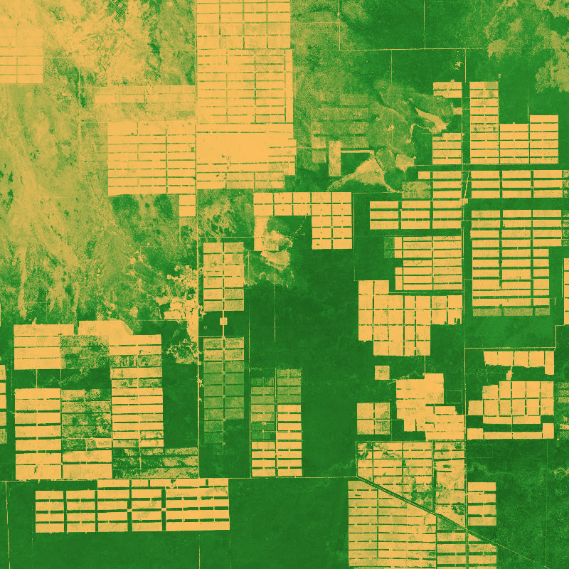
The dataset is based on an analysis combining Sentinel-1 (SAR), -2 (Multispectral) and GEDI (Global Ecosystem Dynamics Investigation, LiDAR) data to model vegetation structure information.
The derived products show high-spatial resolution maps (10 m) of total canopy cover (cover density in %), Foliage height diversity (Fhd) index in meter, Plant area index (Pai) in meter and canopy height (rh95) in meter.
|
|
Citation proposal
German Aerospace Center (DLR). Geo-ForPy - Forest Structure Information for the Paraguayan Chaco - Sentinel-1/2/GEDI, 2019. https://gdk.gdi-de.org/geonetwork/srv/api/records/1ef2d116-ee75-4a22-a83c-572fc0238821 |
Simple
- Date ( Creation )
- 2022-09-01T00:00:00
- Edition
- Presentation form
- Digital map
- Other citation details
- Purpose
- This data set provides a quantitative overview of vegetation structure characteristics of the Paraguayan Chaco comprising various attributes on horizontal and vertical properties.
- Status
- Completed
Point of contact
- Maintenance and update frequency
- As needed
- GEMET - INSPIRE themes, version 1.0 ( Theme )
-
- Land cover
- Spatial scope
- Keywords
-
- opendata
- DLR
- EOC
- GeoForPy
- Forest
- Forest Structure
- Sentinel-1
- Sentinel-2
- GEDI
- Paraguay
- Use limitation
- Nutzungseinschränkungen: Das DLR ist nicht haftbar für Schäden, die sich aus der Nutzung ergeben. / Use Limitations: DLR not liable for damage resulting from use.
- Access constraints
- Other restrictions
- Use constraints
- Other restrictions
- Other constraints
- Nutzungsbedingungen: Lizenz, https://creativecommons.org/licenses/by/4.0/ Terms of use: License, https://creativecommons.org/licenses/by/4.0/
- Other constraints
-
{"id": "cc-by-4.0",
"name": "Creative-Commons - Attribution 4.0 International (CC BY 4.0)",
"url": "http://dcat-ap.de/def/licenses/cc-by/4.0",
"quelle": "Copyright DLR (2022)"}
- Spatial representation type
- Grid
- Denominator
- 20000
- Metadata language
- English English
- Character set
- UTF8
- Topic category
-
- Biota
))
- Number of dimensions
- 2
- Dimension name
- Column
- Dimension size
- 57879
- Resolution
- 10 m
- Dimension name
- Row
- Dimension size
- 68333
- Resolution
- 10 m
- Cell geometry
- Area
- Transformation parameter availability
- false
- Distribution format
-
- GeoTIFF ()
- OnLine resource
-
FOREST_COVER_S2_PRY
WMS Access: Forest Cover Structures in the Paraguayan Chaco: Total Canopy Cover
- OnLine resource
-
FOREST_FHD_S2_PRY
WMS Access: Forest Cover Structures in the Paraguayan Chaco: Foliage Height Diversity Index
- OnLine resource
-
FOREST_PAI_S2_PRY
WMS Access: Forest Cover Structures in the Paraguayan Chaco: Plant Area Index
- OnLine resource
-
FOREST_RH95_S2_PRY
WMS Access: Forest Cover Structures in the Paraguayan Chaco: Canopy Height (95th percentile)
- OnLine resource
-
HTTP download Geo-ForPy - Paraguayan Chaco, 2019
HTTP download Geo-ForPy - Paraguayan Chaco, 2019
- OnLine resource
-
Geo-ForPy - Deforestration in Latin America and the Paraguayan Chaco
Geo-ForPy - project Webpage
- Hierarchy level
- Dataset
Domain consistency
- Measure identification
- INSPIRE / Conformity_001
Conformance result
- Date ( Publication )
- 2010-12-08
- Explanation
- See the referenced specification.
- Pass
- true
- Statement
- This dataset provides large-scale information on vegetation structure information (canopy height, total canopy cover, plant area index, foliage height diversity index), that allows for a complete understanding of spatial characteristics for the complete Paraguayan Chaco, when combined with the other modelled data sets.
- Description
-
Geo-ForPy - Forest Structure Information for the Paraguayan Chaco - Processing
Data:
The data basis for modelling comprises data from Synthetic-Aperture-Radar (SAR) from Sentinel-1, multispectral Information from Sentinel-2 and LiDAR (Light detection and ranging) data from GEDI. All data has been filtered to the period of the dry season 2019 (April to September).
Processing:
GEDI data has been preprocessed (quality and temporal filtering) on a local machine (16 GB RAM). Sentinel preprocessing (Sentinel-1: radiometric terrain normalization and speckle filtering; Sentinel-2 cloud masking, vegetation indices, temporal-spectral metrics) and modelling has been fully conducted in Google Earth Engine using the Python API.
Quality Assurance:
Cover: Modeling accuracy for total canopy cover amounts to: 61.4 % in R² (coefficient of determination) and 9.1 % in RMSE (root mean square error).
Fhdi: Modeling accuracy for Foliage height diversity index amounts to: 48,0 % in R² (coefficient of determination) and 0,3 in RMSE (root mean square error).
Pai: Modeling accuracy for Plant area index amounts to: 50,6 % in R² (coefficient of determination) and 0,3 in RMSE (root mean square error).
rh95 Modeling accuracy for canopy height amounts to: 64,0 % in R² (coefficient of determination) and 1,6 m in RMSE (root mean square error).
gmd:MD_Metadata
- File identifier
- 1ef2d116-ee75-4a22-a83c-572fc0238821 XML
- Metadata language
- English English
- Character set
- UTF8
- Hierarchy level
- Dataset
- Hierarchy level name
- Dataset
- Date stamp
- 2024-06-20T13:06:55
- Metadata standard name
- ISO 19115-1:2014/19139
Point of contact
Overviews
Provided by
