 www.geodatenkatalog.de (S1L)
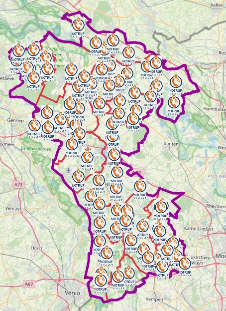
Notrufstellen Kreis Kleve
Im Falle eines Stromausfalls sind die Feuerwehrgerätehäuser in allen Ortschaften der Städte und Gemeinden als Notrufstellen besetzt.
Dorthin kann sich die Bevölkerung wenden, um auch beim Ausfall der üblichen Kommunikationswege Notrufe an die Kreisleitstelle (Telefon 112) abzusetzen.
Es handelt sich um keine dauerhafte Einrichtungen und werden von den Städten und Gemeinden bei Bedarf im Fall eines Notfalls besetzt.
|
|
Citation proposal
(2023) . Notrufstellen Kreis Kleve. Kreis Kleve - Der Landrat https://gdk.gdi-de.org/geonetwork/srv/api/records/1f024819-37ef-4c80-9e56-99185283f078 |
INSPIRE
Identification
- File identifier
- 1f024819-37ef-4c80-9e56-99185283f078 XML
- Hierarchy level
- dataset Dataset
Online resource
Resource identifier
- Metadata language
- German
Encoding
Projection
Classification of data and services
- Topic category
-
- Health
- Society
- Utilities communication
Classification of data and services
Coupled resource
Coupled resource
Classification of data and services
Coupled resource
Coupled resource
Keywords
Other keywords
- Keywords
-
- Kreis Kleve
- Bedburg-Hau
- Emmerich am Rhein
- Emmerich
- Geldern
- Goch
- Issum
- Kalkar
- Kerken
- Wallfahrtsstadt Kevelaer
- Kevelaer
- Kranenburg
- Kleve
- Rees
- Rheurdt
- Straelen
- Uedem
- Wachtendonk
- Weeze
- NW
- NRW
- Nordrhein-Westfalen
- Notfallanlaufstellen
- Notfall
- Leuchttürme
- Leuchtturm
- Blackout
- 05154
- Anlaufstelle
- Notfall-Infopunkte
- Notfallinfopunkt
- Notrufstelle
- Open Data
- opendata
- Keywords ( Theme )
-
- SOCI
Geographic coverage
N
S
E
W
))
Temporal reference
Temporal extent
Temporal extent
- Date ( Publication )
- 2023-06-30T00:00:00.000+02:00
Quality and validity
- Lineage
- von kommunaler Instanz gemeldet
Conformity
Conformity
Conformity
Conformity
Conformity
Conformity
Restrictions on access and use
- Access constraints
- Open Data Commons Open Database License (ODbL)
- Access constraints
- {"id":"odbl","name":"Open Data Commons Open Database License (ODbL)","url":"https://www.opendefinition.org/licenses/odc-odbl","quelle":""}
- Access constraints
- © OpenStreetMap-Mitwirkende
- Access constraints
- Quellenvermerk: https://www.openstreetmap.org/copyright
Restrictions on access and use
Responsible organization (s)
Contact for the resource
- Organisation name
- Kreis Kleve - Der Landrat
- info@kreis-kleve.de
- Organisation name
- Kreis Kleve - Abt. Kataster- und Vermessung - Produktbereich GeoInformation (GIS)
Responsible organization (s)
Contact for the resource
- Organisation name
- Kreis Kleve - Der Landrat
- info@kreis-kleve.de
- Organisation name
- Kreis Kleve - Abt. Kataster- und Vermessung - Produktbereich GeoInformation (GIS)
Metadata information
Contact for the metadata
- Organisation name
- Kreis Kleve - Abt. Kataster- und Vermessung - Produktbereich GeoInformation (GIS)
- Date stamp
- 2025-07-02
- Metadata language
- German
SDS
Conformance class 1: invocable
Access Point URL
Endpoint URL
Technical specification
Conformance class 2: interoperable
Coordinate reference system
Quality of Service
Access constraints
Limitation
Use constraints
Limitation
Responsible custodian
Contact for the resource
Conformance class 3: harmonized
Overviews
Notrufstellen im Kreis Kleve
Provided by

Views
1f024819-37ef-4c80-9e56-99185283f078
Access to the portal
Read here the full details and access to the data.
Associated resources
Not available