 www.geodatenkatalog.de (S3L)
Processed seismic data of Cruise BGR95 1995
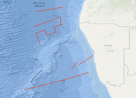
The cruise BGR95 from 19th November to 28th December 1995 with M.S. AKADEMIK NEMCHINOV was designed to acquire new marine geophysical data for a better understanding of the geological processes and structural variations of the Cretaceous-aged oceanic crust of the Angola Basin in the South Atlantic regarding its reflectivity pattern, its shape of the basement surfaces and its crustal thickness. These evaluations were extended onshore to the ‘Damara Igneous Province’. The aim of this study was the investigation of the rift-related volcanic-magmatic processes accompanying the initial stage of the opening of the South Atlantic Ocean. The survey was a co-operation of BGR, Alfred Wegener Institute for Polar and Marine Research (AWI), GeoForschungsZentrum Potsdam, University of Göttingen and Johann Wolfgang Goethe-University Frankfurt/Main. The M.S. AKADEMIK NEMCHINOV generated the seismic signals by a tuned airgun array of 3260 cu.in. (= 53.4 l) together with two AWI owned large volume guns of 2 x 2000 cu.in. (= 65.6 l), recorded the MCS signals with a 3000 m streamer and controlled the shot releases for the ocean bottom hydrophones (OBH’s) and the onshore seismic stations (PEDAS). A total of 5,114 km of multichannel seismic reflection data in parallel with magnetic and gravity measurements have been collected onboard the M.S. AKADEMIK NEMCHINOV. 1069.4 km of the seismic work was done on 3 combined refraction/wide angle offshore and onshore traverses. The offshore part was recorded by 7 ocean bottom hydrophones (OBH) operated by the M.V. POLAR QUEEN (Reichert et al., 1996). The registration onshore Namibia was performed by 25 mobile seismic landstations (PEDAS) on each profile (Schulze et al., 1996). First results are described in the offshore and onshore reports of these investigations (Reichert et al., 1996, and Schulze et al., 1996). The data clearly show distinct series of the seaward dipping reflector sequences (SRDS) and isochronous variations in the accretion of the oceanic crust. The onshore and offshore registrations show deep arrivals from diving and refracted waves in a range up to 200 to 400 km.
|
|
Citation proposal
. Processed seismic data of Cruise BGR95 1995. https://gdk.gdi-de.org/geonetwork/srv/api/records/1f9e063a-70ad-484b-bfe0-80b53a4ba134 |
Simple
- Alternate title
- BGR95 1995
- Date ( Creation )
- 1995-12-28
- Identifier
- eaff0506-3712-4992-9737-bcf3923ab4ea
- Status
- completed Completed
Point of contact
- GEMET - INSPIRE themes, version 1.0 ( Theme )
-
- Geologie
- geology
- GEMET - Concepts, version 2.4 ( Theme )
-
- geophysics
- Geophysik
- raw material
- Rohstoff
- Keywords ( Theme )
-
- Marine geology
- Meeresgeologie
- Seismics
- Seismik
- Two-dimensional seismic reflection
- zweidimensionale Reflektionsseismik
- Keywords ( Place )
-
- Southeast Atlantic Ocean
- Südost-Atlantik
- Angola Basin
- Angola Becken
- Namibia
- Access constraints
- Other restrictions
- Use constraints
- Other restrictions
- Other constraints
- Allgemeine Geschäftsbedingungen, siehe http://www.bgr.bund.de/AGB - General terms and conditions, see http://www.bgr.bund.de/AGB_en. Die bereitgestellten Informationen sind bei Weiterverwendung wie folgt zu zitieren: Datenquelle: BGR95 1995, (c) BGR, Hannover, 1995
- Spatial representation type
- Vector
- Metadata language
- English
- Character set
- UTF8
- Topic category
-
- Geoscientific information
N
S
E
W
))
- Distribution format
-
- Shapefile (n/a )
- Transfer size
- 2
- OnLine resource
-
BGR95 1995 (Shapefile)
BGR95 1995 im Format ESRI Shape
- OnLine resource
-
Profile BGR95-02
Profile BGR95-02
- OnLine resource
-
Profile BGR95-02A
Profile BGR95-02A
- OnLine resource
-
Profile BGR95-05
Profile BGR95-05
- OnLine resource
-
Profile BGR95-07
Profile BGR95-07
- OnLine resource
-
Profile BGR95-08
Profile BGR95-08
- OnLine resource
-
Profile BGR95-10
Profile BGR95-10
- OnLine resource
-
Profile BGR95-11
Profile BGR95-11
- OnLine resource
-
Karte im BGR-Geoviewer
Karte im BGR-Geoviewer
- Hierarchy level
- Dataset
Conformance result
- Date ( Publication )
- 2010-12-08
- Explanation
- siehe dazu die angegebene Durchführungsbestimmung
- Statement
- During the period from 19th November to 28th December 1995 BGR acquired seismic lines off Namibia. The lines BGR95-01, BGR95-03, BGR95-04, BGR95-06, BGR95-09 and BGR95-12 are raw data. The lines BGR95-02, BGR95-02A, BGR95-05, BGR95-07, BGR95-08, BGR95-10, BGR95-11 are processed (migrated) data.
gmd:MD_Metadata
- File identifier
- 1f9e063a-70ad-484b-bfe0-80b53a4ba134 XML
- Metadata language
- English
- Character set
- UTF8
- Parent identifier
- 06a73c56-06a2-40d8-b806-466222b0760d
- Hierarchy level
- Dataset
- Hierarchy level name
- Geophysik
- Date stamp
- 2023-11-16
- Metadata standard name
- INSPIRE Metadata Implementing Rules: Technical Guidelines based on EN ISO 19115 and EN ISO 19119
- Metadata standard version
- n/a
Point of contact
Overviews
Provided by

Views
1f9e063a-70ad-484b-bfe0-80b53a4ba134
Access to the portal
Read here the full details and access to the data.
Associated resources
Not available