 www.geodatenkatalog.de (S1L)
Besondere naturräumliche Eigenart der Böden 1990 (Umweltatlas)
Darstellung der besonderen naturräumlichen Eigenart der Böden auf Block- und Blockteilflächen-Basis, 1 : 50.000, Stand 1990.
|
|
Citation proposal
(2002) . Besondere naturräumliche Eigenart der Böden 1990 (Umweltatlas). https://gdk.gdi-de.org/geonetwork/srv/api/records/21adc103-92cd-3d61-9fbb-8b11a0f80c4b |
- Identification
- Distribution
- Quality
- Spatial rep.
- Ref. system
- Content
- Portrayal
- Metadata
- Md. constraints
- Md. maintenance
- Schema info
Identification
Identification info
Service Identification (19119)
Citation
- Date ( Creation )
- 2000-12-31
- Date ( Publication )
- 2002-07-01
- Presentation form
- Digital map
Point of contact
Point of contact
- Maintenance and update frequency
- Not planned
- Keywords ( Theme )
-
- open data
- opendata
- Karten
- Sachdaten
- Geodaten
- Berlin
- Umweltatlas
- Boden
- Geologie
- Austauschhäufigkeit des Bodenwassers
- Besondere naturräumliche Eigenart
- Bindungsstärke an Schwermetalle
- Filtervermögen
- Nährstoffspeichervermögen
- Schadstoffbindungsvermögen
- Nährstoffversorgung
- Naturnähe
- Regionale Seltenheit der Bodengesellschaften
- Versickerung
- Regelungsfunktion
- Wasserhaushalt
- Bodenfunktionen
- Bodenfunktionskarte
- Bodenbewertung
- Kriterien zur Bewertung der Bodenfunktionen
- Räumlicher Anwendungsbereich ( Theme )
- Keywords
-
- infoMapAccessService
Legal constraints
- Access constraints
- Other restrictions
Legal constraints
- Use constraints
- Other restrictions
- Other constraints
- Für die Nutzung der Daten ist die Datenlizenz Deutschland - Zero - Version 2.0 anzuwenden. Die Lizenz ist über https://www.govdata.de/dl-de/zero-2-0 abrufbar.
- Other constraints
- {"id":"dl-zero-de/2.0","name":"Datenlizenz Deutschland - Zero - Version 2.0","url":"https://www.govdata.de/dl-de/zero-2-0"}
- Service Type
- view
- Service Version
- OGC:WMS 1.0.0
- Service Version
- OGC:WMS 1.1.0
- Service Version
- OGC:WMS 1.1.1
- Service Version
- OGC:WMS 1.3.0
Extent
N
S
E
W
))
Geographic description
- Extent type code
- true
- Geographic identifier
- 110000000000
- Coupling Type
- Tight
Contains Operations
- Operation Name
- GetCapabilities
- Distributed Computing Platforms
- Web services
- Operates On
Distribution
Distribution
- Distribution format
-
-
Text/HTML
(4.01 )
- Specification
- Keine Angabe
-
Text/HTML
(4.01 )
- OnLine resource
-
Darstellungsdienst - Besondere naturräumliche Eigenart der Böden 1990 (Umweltatlas) (WMS)
Darstellungsdienst - Besondere naturräumliche Eigenart der Böden 1990 (Umweltatlas) (WMS)
- OnLine resource
-
Darstellung der Karte im Geoportal Berlin
Darstellung der Karte im Geoportal Berlin
Quality
Scope
- Hierarchy level
- Service
- Other
- Dienst
Ref. system
- Reference system identifier
- http://www.opengis.net/def/crs/EPSG/0/25833
Metadata
Metadata
- File identifier
- 21adc103-92cd-3d61-9fbb-8b11a0f80c4b XML
- Metadata language
- German
- Character set
- UTF8
- Hierarchy level
- Service
- Hierarchy level name
- Kriterien zur Bewertung der Bodenfunktionen 1990 (Umweltatlas) Dienst
- Date stamp
- 2025-11-19T00:00:00Z
- Metadata standard name
- ISO 19115/19119 - BE
- Metadata standard version
- 1.0.0
Point of contact
Overviews
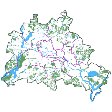
Vorschaubild
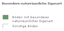
Legende
Provided by

Views
21adc103-92cd-3d61-9fbb-8b11a0f80c4b
Access to the portal
Read here the full details and access to the data.
Associated resources
Not available