 www.geodatenkatalog.de (S3L)
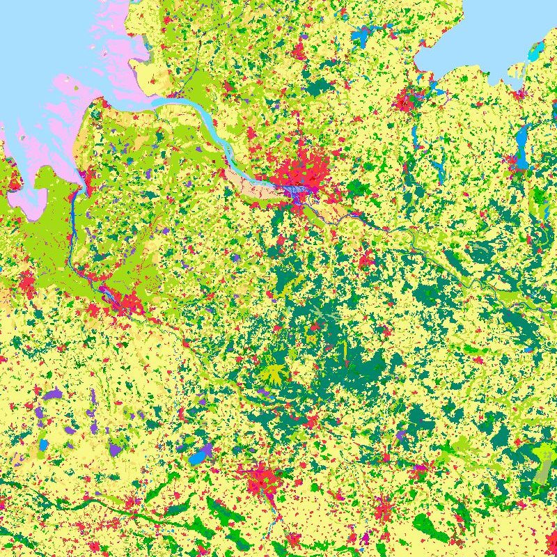
CORINE Land Cover 2000 - Germany
The objective of the pan-European project CORINE Land Cover (CLC) is the provision of a unique and comparable data set of land cover for Europe and the delivery of regular updates to register also the land cover and land use changes over time. It is part of the European Union programme CORINE (Coordination of Information on the Environment). The mapping of the land cover and land use was performed on the basis of satellite remote sensing images. The first CLC data base CLC1990, which was finalized in the 1990s, consistently provided land use information comprising 44 classes, out of which 37 classes are relevant in Germany. The first two updates for Europe were based on the reference years 2000 and 2006. For Germany, DLR-DFD was responsible for the creation of CLC2000 and CLC2006 on behalf of the Federal Environment Agency. In addition to the updated land cover, change datasets were also parts of the project. For deriving a meaningful CLC2000 change product, it became necessary to re-interprete parts of the satellite data of 1990 and to create a revised product, called CLC1990 (rev).
Further details:
https://www.dlr.de/en/eoc/research-transfer/projects-missions/corine-land-cover
|
|
Citation proposal
. CORINE Land Cover 2000 - Germany. https://gdk.gdi-de.org/geonetwork/srv/api/records/229eccaf-bace-4e93-b8a5-a66568993b0f |
Simple
- Date ( Creation )
- 2004-12-21T00:00:00
- Edition
- Presentation form
- Digital map
- Credit
- The CLC2000 project in Germany was executed using financial support by DG Regio and the German Federal Ministry on Environment, Nature Conservation and Nuclear Safety (BMU) on behalf of the German Federal Environmental Agency (UBA), project no. UBA FKZ 201 12 209.
- Status
- Completed
Point of contact
Point of contact
- Maintenance and update frequency
- Not planned
- Date of next update
- 2006-01-01
- GEMET - INSPIRE themes, version 1.0 ( Theme )
-
- Land cover
- Spatial scope ( Place )
- Keywords
-
- CORINE
- CORINE_2000
- Germany
- Use limitation
- Nutzungseinschränkungen: DLR not liable for damage resulting from use
- Access constraints
- Restricted
- Use constraints
- Other restrictions
- Other constraints
- Nutzungsbedingungen: For terms of use, see https://geoservice.dlr.de/resources/licenses/corine/CORINE_termsofuse_en.pdf Reference for the use of CLC2000 products in publications: CORINE Land Cover (CLC2000); Federal Environment Agency, DLR-DFD 2004.
- Spatial representation type
- Grid
- Denominator
- 200000
- Metadata language
- eng
- Character set
- UTF8
- Topic category
-
- Imagery base maps earth cover
))
- Reference system identifier
- EPSG / ETRS89 / LAEA Europe (EPSG:3035) / 8.6
- Reference system identifier
- EPSG / ETRS89 / UTM zone 32N (N-E) (EPSG:3044) / 8.6
- Distribution format
-
- ()
- OnLine resource
-
CORINE_LAND_COVER_2000_250x250_LAEA
WMS Access CORINE Land Cover 2000 250m x 250m LAEA
- OnLine resource
-
CORINE_LAND_COVER_2000_1000x1000_LAEA
WMS Access CORINE Land Cover 2000 1000m x 1000m LAEA
- OnLine resource
-
CORINE_LAND_COVER_2000_100x100_ETRS89
WMS Access CORINE Land Cover 2000 100m x 100m ETRS89
- OnLine resource
-
CORINE_LAND_COVER_2000_250x250_ETRS89
WMS Access CORINE Land Cover 2000 250m x 250m ETRS89
- OnLine resource
-
CORINE_LAND_COVER_2000_1000x1000_ETRS89
WMS Access CORINE Land Cover 2000 1000m x 1000m ETRS89
- OnLine resource
-
Overview Corine Land Cover products at DFD
Detailed Information
- OnLine resource
-
Corine DFD Project Website
Detailed Information
- Hierarchy level
- Dataset
Domain consistency
- Measure identification
- INSPIRE / Conformity_001
Conformance result
- Date ( Publication )
- 2010-12-08
- Explanation
-
Keil, M., Kiefl, R., Strunz, G. (2005): CORINE Land Cover 2000 - Germany. Final Report. German Aerospace Center, German Remote Sensing Data Center Oberpfaffenhofen, July 2005.
https://www.umweltbundesamt.de/sites/default/files/medien/publikation/long/3212.pdf
- Pass
- true
- Statement
-
For details see:
https://www.dlr.de/en/eoc/research-transfer/projects-missions/corine-land-cover and https://geoservice.dlr.de/resources/pdf/corine/CORINE_Land_Cover_products_for_Germany_at_DFD.pdf
- Description
gmd:MD_Metadata
- File identifier
- 229eccaf-bace-4e93-b8a5-a66568993b0f XML
- Metadata language
- English
- Character set
- UTF8
- Hierarchy level
- Dataset
- Date stamp
- 2024-09-27T14:14:48
- Metadata standard name
- 19115-1:2014/19139
- Metadata standard version
- 1.0
Point of contact
Overviews
Provided by
