 www.geodatenkatalog.de (S1L)
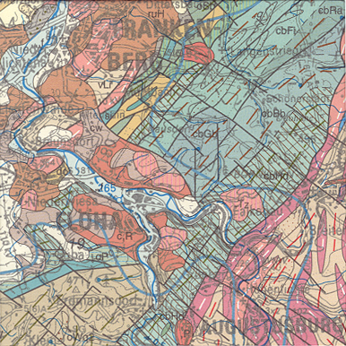
General Geological Map of the Federal Republic of Germany 1:200,000 (GUEK200) - CC 5542 Dresden
The map series General Geological Map of the Federal Republic of Germany 1:200,000 (GÜK200) is the result of cooperation between the State Geological Surveys of the Federal Republic of Germany (SGD), the Geological Surveys of neighbouring countries and the Federal Institute for Geosciences and Natural Resources (BGR). The GÜK200 displays the surface geology of Germany and adjacent areas of neighbouring countries on 55 map sheets. The map sheets show the regional dissemination of more than 3800 geological units. The geological units contain information on stratigraphy (age), genesis and petrography (composition) of the rocks.
|
|
Citation proposal
(2007) . General Geological Map of the Federal Republic of Germany 1:200,000 (GUEK200) - CC 5542 Dresden. https://gdk.gdi-de.org/geonetwork/srv/api/records/279E0093-0747-4CEB-9A4C-96F7F8C0F73B |
INSPIRE
Identification
- File identifier
- 279E0093-0747-4CEB-9A4C-96F7F8C0F73B XML
- Hierarchy level
- dataset Dataset
Online resource
Resource identifier
- code
- 25FD1744-4A84-4F03-B7E5-20956F80996B
- Metadata language
- ger German
- Spatial representation type
- Grid
- Spatial representation type
- Vector
Encoding
- Format
- Version
- n/a
- Format
- Shapefile
- Version
- n/a
- Format
- JPEG
- Version
- n/a
- Format
- TIFF
- Version
- n/a
- Format
- gedruckt
- Version
- n/a
- Format
- georef. TIFF
- Version
- n/a
Projection
Classification of data and services
- Topic category
-
- Geoscientific information
Classification of data and services
Coupled resource
Coupled resource
Classification of data and services
Coupled resource
Coupled resource
Keywords
- GEMET - INSPIRE themes, version 1.0 ( Theme )
-
- Geologie
- Geology
Other keywords
- Keywords ( Theme )
-
- Allgemeine Geologie
- Devon
- Eisrandlagen
- Genese
- Geologische Karte
- Kambrium
- Känozoikum
- Karbon
- Kreide
- Magmatisches Gestein
- Mesozoikum
- Metamorphes Gestein
- Ordovizium
- Paläozoikum
- Perm
- Petrographie
- Präkambrium
- Proterozoikum
- Quartär
- Rasterdaten
- Sedimentgestein
- Silur
- Stratigraphie
- Tektonik
- Tertiär
- Trias
- Vektordaten
- Keywords ( Place )
-
- Sachsen
- Keywords
-
- opendata
Geographic coverage
N
S
E
W
))
Temporal reference
Temporal extent
Temporal extent
- Date ( Publication )
- 2007-03-14
Quality and validity
- Lineage
- -
- Denominator
- 200000
Conformity
Conformity
Conformity
Conformity
Conformity
Conformity
Restrictions on access and use
- Access constraints
- Allgemeine Geschäftsbedingungen, s. https://www.bgr.bund.de/agb - General Terms and Conditions, s. https://www.bgr.bund.de/agb_en
- Access constraints
- Dieser Datensatz kann gemäß der "Nutzungsbestimmungen für die Bereitstellung von Geodaten des Bundes" (https://sg.geodatenzentrum.de/web_public/gdz/lizenz/geonutzv.pdf) genutzt werden.
- Access constraints
- Preis der gedruckten Karte: 14,02 EUR (zzgl. 7% MWSt. und Versandkosten) Weitere Informationen zur Bestellung beim Internationalen Landkartenhaus siehe https://www.bgr.bund.de/produktcenter-bestellhinweis-ILH
- Access constraints
- {"id": "geoNutz/20130319", "name": "Nutzungsbestimmungen für die Bereitstellung von Geodaten des Bundes", "url": "https://sg.geodatenzentrum.de/web_public/gdz/lizenz/geonutzv.pdf", "quelle": "Bundesanstalt für Geowissenschaften und Rohstoffe (BGR)"}
Restrictions on access and use
Responsible organization (s)
Contact for the resource
- Organisation name
- Bundesanstalt für Geowissenschaften und Rohstoffe
- geologie.daten@bgr.de
Responsible organization (s)
Contact for the resource
- Organisation name
- Bundesanstalt für Geowissenschaften und Rohstoffe
- geologie.daten@bgr.de
Metadata information
Contact for the metadata
- Organisation name
- Bundesanstalt für Geowissenschaften und Rohstoffe (BGR)
- Date stamp
- 2022-08-17
- Metadata language
- German
- Character set
- utf8 UTF8
SDS
Conformance class 1: invocable
Access Point URL
Endpoint URL
Technical specification
Conformance class 2: interoperable
Coordinate reference system
Quality of Service
Access constraints
Limitation
Use constraints
Limitation
Responsible custodian
Contact for the resource
Conformance class 3: harmonized
Overviews
Provided by

Views
279E0093-0747-4CEB-9A4C-96F7F8C0F73B
Access to the portal
Read here the full details and access to the data.
Associated resources
Not available