 www.geodatenkatalog.de (S3L)
Processed seismic data of Cruise SO75 1991
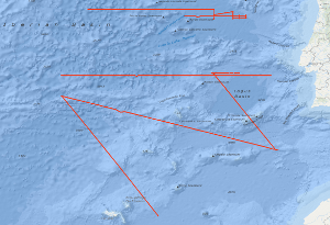
The main purpose of the cruise SO75 from 14th October to 12th November 1991 was to test the new instrumentation of the SONNE and the ship itself for the needs of marine geophysics. The second purpose was the investigation of the crustal structure of the Atlantic Ocean from the Madeira-Torre Rise to the continental slope of Portugal which is conjugate to the margin off Newfoundland being investigated by a previous BGR cruise (Hinz et al., 1989). Methods used were multichannel reflection seismics, gravimetry, magnetics, swath echosounding and sediment echography. The test of the ship and its result is discussed in a separate technical report (Roeser et al., 1991). On two lines crossing the Madeira-Torre Rise we have observed seaward dipping reflector sequences. Their position is conjugate to similar features observed off Newfoundland. Magnetic models for one line show a strong magnetization of the whole reflector sequence. Thus, in analogy to the drilled dipping reflector sequence on the Vøring Plateau, it is likely that it mainly consists of lava flows which were extruded subaerially or in shallow water. In contrast to the dipping reflector sequences found earlier, the newly detected sequences are far away from continental crust. Presumably, at the time of their formation the Midatlantic Ridge was subaerial. Geometrical constraints indicate a compressional regime for the eastern part of the Azores-Gibraltar Fracture Zone. Most prominent expression of this is the Gorringe Bank. Our seismic line across it indicates an overthrusting of oceanic crust, however, it does not show any evidence for a Benioff zone. Therefore, only a small amount of oceanic crust can be subducted until now. We have observed compressional features also in the Tagus Abyssal Plain. Our lines north of the Azores-Gibraltar Fracture Zone did not confirm the weak indications for a continuation of the magnetic anomaly M0 across the fracture zone. The present platetectonic models for this area require therefore a modification. For the definition of the ocean-continent transition in the Iberia Abyssal Plain and for the investigation of the nature of the crust near the transition zone 6 ODP drillsites have been proposed. In response to a request by R.B. Whitmarsh from the Institute of Oceanographic Sciences at Wormley, Godalming, we have carried out the required ODP Site Survey.
|
|
Citation proposal
. Processed seismic data of Cruise SO75 1991. https://gdk.gdi-de.org/geonetwork/srv/api/records/27d217f3-9e7e-4661-b687-dad99297243e |
INSPIRE
Identification
- File identifier
- 27d217f3-9e7e-4661-b687-dad99297243e XML
- Hierarchy level
- Dataset
Online resource
Resource identifier
- code
- e918b264-9d4c-a9c8-5577-f69b77986aa0
- Metadata language
- English
- Spatial representation type
- Vector
Encoding
- Format
- Shapefile
- Version
- n/a
Projection
Classification of data and services
- Topic category
-
- Geoscientific information
Classification of data and services
Coupled resource
Coupled resource
Classification of data and services
Coupled resource
Coupled resource
Keywords
- GEMET - INSPIRE themes, version 1.0 ( Theme )
-
- Geologie
- geology
- GEMET - Concepts, version 2.4 ( Theme )
-
- geophysics
- Geophysik
- raw material
- Rohstoff
Other keywords
- Keywords ( Theme )
-
- Marine geology
- Meeresgeologie
- Seismics
- Seismik
- Two-dimensional seismic reflection
- zweidimensionale Reflektionsseismik
- Keywords ( Place )
-
- Nordatlanik
- North Atlantic Ocean
- Azoren-Gibraltar-Bruchzone
- Azores-Gibraltar Fracture Zone
- Madeira-Torre-Rücken
- Madeira-Torre Rise
- Gorringe-Bank
Geographic coverage
N
S
E
W
))
Temporal reference
Temporal extent
Temporal extent
- Date ( Creation )
- 1991-11-12
Quality and validity
- Lineage
- During the period from the 14th October to the 12th November 1991 BGR acquired seismic lines in the Iberian Basin. All lines from SO75-001 to SO75-022 are raw data.
Conformity
Conformity
Conformity
Conformity
Conformity
Conformity
- Explanation
- siehe dazu die angegebene Durchführungsbestimmung
Restrictions on access and use
- Access constraints
- Allgemeine Geschäftsbedingungen, siehe http://www.bgr.bund.de/AGB - General terms and conditions, see http://www.bgr.bund.de/AGB_en. Die bereitgestellten Informationen sind bei Weiterverwendung wie folgt zu zitieren: Datenquelle: SO75 1991, (c) BGR, Hannover, 1991
Restrictions on access and use
Responsible organization (s)
Contact for the resource
- Organisation name
- Federal Institute for Geosciences and Natural Resources
- Marine_Seismik@bgr.de
Responsible organization (s)
Contact for the resource
- Organisation name
- Federal Institute for Geosciences and Natural Resources
- Marine_Seismik@bgr.de
Metadata information
Contact for the metadata
- Organisation name
- Bundesanstalt für Geowissenschaften und Rohstoffe (BGR)
- Date stamp
- 2023-11-14
- Metadata language
- English
- Character set
- UTF8
SDS
Conformance class 1: invocable
Access Point URL
Endpoint URL
Technical specification
Conformance class 2: interoperable
Coordinate reference system
Quality of Service
Access constraints
Limitation
Use constraints
Limitation
Responsible custodian
Contact for the resource
Conformance class 3: harmonized
Overviews
Provided by

Views
27d217f3-9e7e-4661-b687-dad99297243e
Access to the portal
Read here the full details and access to the data.
Associated resources
Not available