 www.geodatenkatalog.de (S1L)
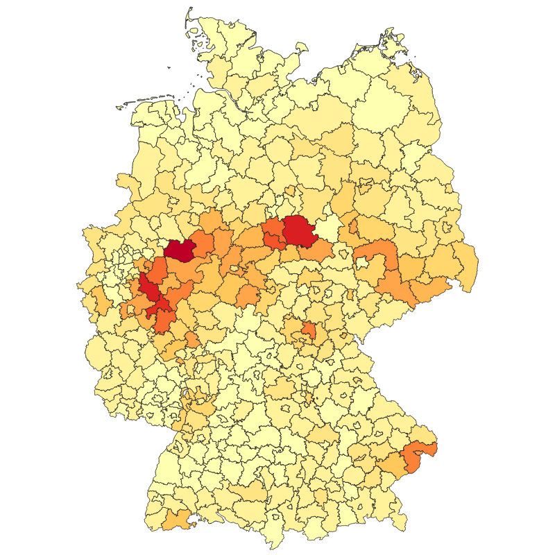
Tree Canopy Cover Loss Yearly per District - Germany, 2018-2021
|
|
Citation proposal
German Aerospace Center (DLR). Tree Canopy Cover Loss Yearly per District - Germany, 2018-2021. https://gdk.gdi-de.org/geonetwork/srv/api/records/281e0d18-0ae0-449f-88ee-acab8626a77f |
Simple
- Date ( Creation )
- 2022-08-11T00:00:00
- Edition
- Presentation form
- Digital map
- Other citation details
- Purpose
- This map shows the tree canopy cover losses in Germany per district from 2018 to 2021.
- Status
- Completed
Point of contact
- Maintenance and update frequency
- As needed
- GEMET - INSPIRE themes, version 1.0 ( Theme )
-
- Land cover
- Spatial scope ( Place )
- Keywords
-
- opendata
- Forest
- Canopy Cover Loss
- Drought
- Disturbance Index
- Sentinel-2
- Landsat-8
- Germany
- Use limitation
- Nutzungseinschränkungen: Das DLR ist nicht haftbar für Schäden, die sich aus der Nutzung ergeben. / Use Limitations: DLR not liable for damage resulting from use.
- Access constraints
- Other restrictions
- Use constraints
- Other restrictions
- Other constraints
- Nutzungsbedingungen: Lizenz, https://creativecommons.org/licenses/by/4.0/ Terms of use: License, https://creativecommons.org/licenses/by/4.0/
- Other constraints
-
{"id": "cc-by-4.0",
"name": "Creative-Commons - Attribution 4.0 International (CC BY 4.0)",
"url": "http://dcat-ap.de/def/licenses/cc-by/4.0",
"quelle": "Copyright DLR (2022)"}
- Spatial representation type
- Vector
- Denominator
- 20000
- Metadata language
- English English
- Character set
- UTF8
- Topic category
-
- Biota
))
- Topology level
- Full surface graph
- Geometric object type
- Surface
- Geometric object count
- 403
- Distribution format
-
- Shapefile ()
- Geopackage ()
- OnLine resource
-
EOC Geoservice Dataset
EOC Geoservice Dataset
- OnLine resource
-
TREE_CANOPY_COVER_LOSS_HA_ALLFOREST_P1Y
WMS Access: Tree Canopy Cover Loss Germany per District for all forests in HA (2018-2021)
- OnLine resource
-
TREE_CANOPY_COVER_LOSS_HA_CONIFEROUS_P1Y
WMS Access: Per-District statistics of Coniferous Tree Canopy Cover Loss Germany in ha (2018-2021)
- OnLine resource
-
TREE_CANOPY_COVER_LOSS_HA_DECIDUOUS_P1Y
WMS Access: Per-District statistics of Deciduous Tree Canopy Cover Loss Germany in ha (2018-2021)
- OnLine resource
-
TREE_CANOPY_COVER_LOSS_PERC_ALLFOREST_P1Y
WMS Access: Tree Canopy Cover Loss Germany per District for all forests in % (2018-2021)
- OnLine resource
-
TREE_CANOPY_COVER_LOSS_PERC_CONIFEROUS_P1Y
WMS Access: Per-District statistics of Coniferous Tree Canopy Cover Loss Germany in ha (2018-2021)
- OnLine resource
-
TREE_CANOPY_COVER_LOSS_PERC_DECIDUOUS_P1Y
WMS Access: Per-District statistics of Deciduous Tree Canopy Cover Loss Germany in ha (2018-2021)
- OnLine resource
-
HTTP download Tree Canopy Cover Loss Monthly - Germany, 2018-2021
HTTP download Tree Canopy Cover Loss Monthly - Germany, 2018-2021
- OnLine resource
-
Sorge um den deutschen Wald
DLR News - Webpage
- Hierarchy level
- Dataset
Domain consistency
- Measure identification
- INSPIRE / Conformity_001
Conformance result
- Date ( Publication )
- 2010-12-08
- Explanation
- See the referenced specification.
- Pass
- true
- Statement
- All Sentinel-2 and Landsat-8 data since 2017 available through the Google Earth Engine (GEE) with less than 80 % cloud cover were used.
- Description
-
Tree Canopy Cover Loss - Germany 2018-2021 - Processing
Processing:
The Sentinel-2 level 2 surface reflectance dataset available from GEE was processed using sen2cor and the Landsat-8 level 2 dataset is composed of surface reflectance data processed using the land surface reflectance code (LaSRC).
Quality Assurance:
With regard to the spatial accuracy, our assessment based on pixel counts revealed an overall accuracy of 92.8%. The sample-based accuracy assessment revealed an overall accuracy of 98% ± 1% and an area estimate of 643,735 ha ± 120,726 ha canopy cover loss. This map is a modified version of the paper, where we removed low-confidence losses, particularly during early 2018 and the 2020/21 winter.
gmd:MD_Metadata
- File identifier
- 281e0d18-0ae0-449f-88ee-acab8626a77f XML
- Metadata language
- English English
- Character set
- UTF8
- Hierarchy level
- Dataset
- Hierarchy level name
- Dataset
- Date stamp
- 2025-02-03T08:54:56
- Metadata standard name
- ISO 19115-1:2014/19139
Point of contact
Overviews
Provided by
