 My GeoNetwork catalogue
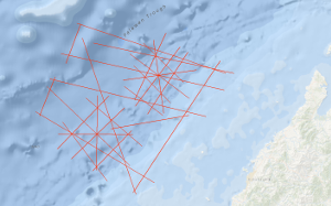
Processed seismic data of Cruise BGR01 POPSCOMS 2001
The main objectives of the BGR cruise BGR01 POPSCOMS (Properties of a Gas Hydrate Province on a Subduction-Collision Related Margin off Sabah) off Sabah/Malaysia with M/V AKADEMIK NEMCHINOV from 4th November to 3rd December 2001 in co-operation with PETRONAS Malaysia are the research on (1) Marine Methane Gas Hydrates: Detection, distribution and formation; relation to the adjacent highly productive "conventional" gas province in the specific tectonic setting of the collisional belt off Sabah. (2) Tectonic development of the (accretionary) margin off Sabah: Improve the tectonic stratigraphic hypothesis of the subducted Proto-South-China-Sea and continental crust under the accretionary wedge, respectively in the subducted plate. Open questions and targets of the survey: Within the help of the already existing magnetic data and other seismic measurement methods (e.g. special refraction seismic with ocean-bottom hydrophones [OBH], which presumably is an exellent and adequate method) we try to discern between oceanic and continental crust in the subducted plate, to investigate the nature of the transition and get information on the subduction angle. This is important in relation to the Cagayan Ridge (Sulu Sea) that is interpreted as an island arc that is related to the subduction of the proto-South China Sea. Another aim was to enable the determination of seismic anisotropy, distribution of BSR's and hydrates in the area and their v(p) to v(s) ratios. Are the gas hydrates related to the adjacent highly productive "conventional" gas province? What is the structural character of the transition zone between the hydrate province and the adjacent conventional gas bearing province further up-slope? Conversely, are there indication for a possible deepwater source? Can initial conclusions be drawn regarding their biogenic or thermogenic origin? Is there an impact of sedimentation conditions, compressional behaviour (e.g. at active margins) and/or structural properties on the genesis and stability of gas hydrates and BSRs (Bottom Simulating Reflectors)? How do the findings under different conditions compare in that regard? Which are the favorable conditions for the genesis of gas hydrates, and can they be detected by geophysical methods even if there are no BSR's? The findings are expected to provide a contribution to the assessment of the deepwater hydrocarbon potential along the continental margin off Sabah. Results: In the study area the BSRs were identified on the base of their polarity reversal with respect to the seafloor and when they transect reflectors from the strata. The widely distributed BSRs along the seismic lines of the survey deliver an indirect indicator for the presence of gas hydrates in the study area (BSR's in post Miocene sediments). The BSR depths below seafloor vary between 250 and 350 m. Differences in the reflection coefficient of the BSRs are mainly related to the amount of free gas beneath the Gas Hydrate Stability Zone.
Simple
- Alternate title
-
BGR01 POPSCOMS 2001
- Date (Creation)
- 2001-12-03
- Citation identifier
- 6331ded2-8dc9-91bf-7338-e920ec362ae1
- Status
- Completed
-
GEMET - INSPIRE themes, version 1.0
-
-
Geologie
-
geology
-
-
GEMET - Concepts, version 2.4
-
-
geophysics
-
Geophysik
-
raw material
-
Rohstoff
-
- Theme
-
-
Marine geology
-
Meeresgeologie
-
Seismics
-
Seismik
-
Two-dimensional seismic reflection
-
zweidimensionale Reflektionsseismik
-
- Place
-
-
South China Sea
-
Südchinesisches Meer
-
Palawan Trough
-
Palawan-Rinne
-
- Access constraints
- Other restrictions
- Other constraints
- Es gelten keine Zugriffsbeschränkungen
- Use constraints
- Other restrictions
- Other constraints
-
Allgemeine Geschäftsbedingungen, siehe http://www.bgr.bund.de/AGB - General terms and conditions, see http://www.bgr.bund.de/AGB_en . Die bereitgestellten Informationen sind bei Weiterverwendung wie folgt zu zitieren: Datenquelle: BGR01 POPSCOMS 2001, (c) BGR, Hannover, 2019
- Spatial representation type
- Vector
- Language
- English
- Character set
- UTF8
- Topic category
-
- Geoscientific information
))
- Unique resource identifier
- EPSG:4326
- Distribution format
-
-
Shapefile
(
n/a
)
-
Shapefile
(
n/a
)
- Transfer size
- 1
- OnLine resource
-
BGR01 POPSCOMS 2001 (Shapefile)
BGR01 POPSCOMS 2001 im Format ESRI Shape
- OnLine resource
- Profile BGR01-01
- OnLine resource
- Profile BGR01-02
- OnLine resource
- Profile BGR01-03
- OnLine resource
- Profile BGR01-04
- OnLine resource
- Profile BGR01-05
- OnLine resource
- Profile BGR01-06
- OnLine resource
- Profile BGR01-07
- OnLine resource
- Profile BGR01-08
- OnLine resource
- Profile BGR01-09
- OnLine resource
- Profile BGR01-10
- OnLine resource
- Profile BGR01-11
- OnLine resource
- Profile BGR01-12
- OnLine resource
- Profile BGR01-A1
- OnLine resource
- Profile BGR01-A2
- OnLine resource
- Profile BGR01-A3
- OnLine resource
- Profile BGR01-A3A
- OnLine resource
- Profile BGR01-A4
- OnLine resource
- Profile BGR01-A5
- OnLine resource
- Profile BGR01-A6
- OnLine resource
- Profile BGR01-A7
- OnLine resource
- Profile BGR01-A7A
- OnLine resource
- Profile BGR01-B1
- OnLine resource
- Profile BGR01-B2
- OnLine resource
- Profile BGR01-B3
- OnLine resource
- Profile BGR01-B4
- OnLine resource
- Profile BGR01-B5A
- OnLine resource
- Profile BGR01-B6
- OnLine resource
- Profile BGR01-B7
- OnLine resource
- Profile BGR01-B8
- OnLine resource
- Profile BGR01-B9
- OnLine resource
- Karte im BGR-Geoviewer
- Hierarchy level
- Dataset
Conformance result
- Date (Publication)
- 2010-12-08
- Explanation
-
siehe dazu die angegebene Durchführungsbestimmung
- Statement
-
In the period from 4th November to 3rd December 2001 BGR acquired seismic lines in the South China Sea and Eastern Archipelagic Seas during cruise BGR01 with M/V AKADEMIK NEMCHINOV. All lines BGR01-01, BGR01-02, BGR01-03, BGR01-04, BGR01-015, BGR01-06, BGR01-07, BGR01-08, BGR01-09, BGR01-11, BGR01-12, BGR01-A1, BGR01-A2, BGR01-A3, BGR01-A3A, BGR01-A4, BGR01-A5, BGR01-A6, BGR01-A7, BGR01-A7A, BGR01-B1, BGR01-B2, BGR01-B3, BGR01-B4, BGR01-B5A, BGR01-B6, BGR01-B7, BGR01-B8 and BGR01-B9 are migrated data.
- File identifier
- 299f631c-566b-4e42-a3a9-0568d09cf5a9 XML
- Metadata language
- English
- Character set
- UTF8
- Parent identifier
-
Marine Seismic Survey Profiles (MSSP)
06a73c56-06a2-40d8-b806-466222b0760d
- Hierarchy level
- Dataset
- Hierarchy level name
-
Geophysik
- Date stamp
- 2023-11-16
- Metadata standard name
-
INSPIRE Metadata Implementing Rules: Technical Guidelines based on EN ISO 19115 and EN ISO 19119
- Metadata standard version
-
n/a
Overviews
Spatial extent
Provided by
