 My GeoNetwork catalogue
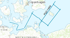
Processed seismic data of Cruise PQ2
Processed seismic data from Baltic Sea with research ship M/V Polar Queen.The data format is Society of Exploration Geophysicists SEG Y. During the period from 14th to 28th of April 1996 BGR and GFZ chartered the Norwegian vessel M/V POLAR QUEEN for testing the new and updated marine seismic equipment of the BGR and for acquiring seismic lines. The operating area was the North Sea and Baltic Sea. The geophysical lines in the Baltic Sea were chosen as extended onshore DEKORP lines to evaluate the deep structure of the south western part of the Baltic Sea. For the seismic profiles a tuned source array consisting of 20 air guns in two linear strings with a total volume of 52 l was used. The recording length was 26 s, the sample rate 4 ms and the shot interval 30 s. This time triggering for the shot release was chosen, because all shots were also recorded onshore by seismic stations for wide angle/refraction acquisition (GFZ). During this leg 810 km reflection lines and additional 230 km pure shooting could be surveyed. The preliminary interpretation of the seismic single traces was restricted on the ship to the upper time range. The main structures in the southern Baltic Sea could be evaluated. A full interpretation especially of the deeper part is only possible after a processing due to the nature of the single traces and the S/N ratio.
- Identification
- Distribution
- Quality
- Spatial rep.
- Ref. system
- Content
- Portrayal
- Metadata
- Md. constraints
- Md. maintenance
- Schema info
Identification
Data identification
Citation
- Alternate title
-
PQ2 1996
- Date (Creation)
- 1996-04-28
- Citation identifier
- f5244629-9ce1-4935-97fa-86fbfa712b44
- Status
- Completed
-
GEMET - INSPIRE themes, version 1.0
-
-
geology
-
Geologie
-
-
GEMET - Concepts, version 2.4
-
-
geophysics
-
Geophysik
-
raw material
-
Rohstoff
-
- Theme
-
-
marine geology
-
Meeresgeologie
-
seismics
-
Seismik
-
two-dimensional seismic reflection
-
zweidimensionale Reflektionsseismik
-
MSSP
-
GeolDG
-
- Place
-
-
Central Baltic Sea
-
Ostsee
-
German EEZ
-
Deutsche AWZ
-
Legal constraints
- Access constraints
- Other restrictions
- Other constraints
- Es gelten keine Zugriffsbeschränkungen
Legal constraints
- Use constraints
- Other restrictions
- Other constraints
-
Allgemeine Geschäftsbedingungen, siehe https://www.bgr.bund.de/AGB - General terms and conditions, see https://www.bgr.bund.de/AGB_en . Die bereitgestellten Informationen sind bei Weiterverwendung wie folgt zu zitieren: Datenquelle: PQ2, (c) BGR, Hannover, 1996
- Spatial representation type
- Vector
- Language
- English
- Character set
- UTF8
- Topic category
-
- Geoscientific information
))
Distribution
Distribution
- Distribution format
-
-
Shapefile
(
n/a
)
-
Shapefile
(
n/a
)
Digital transfer options
- Transfer size
- 1
- OnLine resource
-
PQ2 1996 (Shapefile)
PQ2 1996 im Format ESRI Shape
- OnLine resource
- Profil PQ2-02
- OnLine resource
- Profil PQ2-03
- OnLine resource
- Profil PQ2-04
- OnLine resource
- Profil PQ2-05
- OnLine resource
- Profil PQ2-06
- OnLine resource
- Profil PQ2-08
- OnLine resource
- Profil PQ2-09A
- OnLine resource
- Profil PQ2-09B
- OnLine resource
- Profil PQ2-09C
- OnLine resource
- Profil PQ2-09D
- OnLine resource
- Karte im BGR-Geoviewer
Quality
Data quality
Scope
- Hierarchy level
- Dataset
Conformance result
Citation
- Date (Publication)
- 2010-12-08
- Explanation
-
siehe dazu die angegebene Durchführungsbestimmung
- Statement
-
During the period from 14th to 28th of April 1996 BGR and GFZ acquired seismic lines in the Baltic-Sea. The Lines PQ-002, PQ-003, PQ-04, PQ-05, PQ-06, PQ-08, PQ-09A, PQ-09B, PQ-09C, PQ-09D are processed (stack).
Ref. system
- Unique resource identifier
- EPSG:4326
Metadata
Metadata
- File identifier
- 29a6fbbc-d733-42dd-902e-02ccfec6c3ac XML
- Metadata language
- English
- Character set
- UTF8
- Parent identifier
-
Marine Seismic Survey Profiles (MSSP)
06a73c56-06a2-40d8-b806-466222b0760d
- Hierarchy level
- Dataset
- Hierarchy level name
-
Geophysik
- Hierarchy level name
-
GeolDG
- Date stamp
- 2024-03-04
- Metadata standard name
-
INSPIRE Metadata Implementing Rules: Technical Guidelines based on EN ISO 19115 and EN ISO 19119
- Metadata standard version
-
n/a
Overviews
Spatial extent
Provided by
