 www.geodatenkatalog.de (S3L)
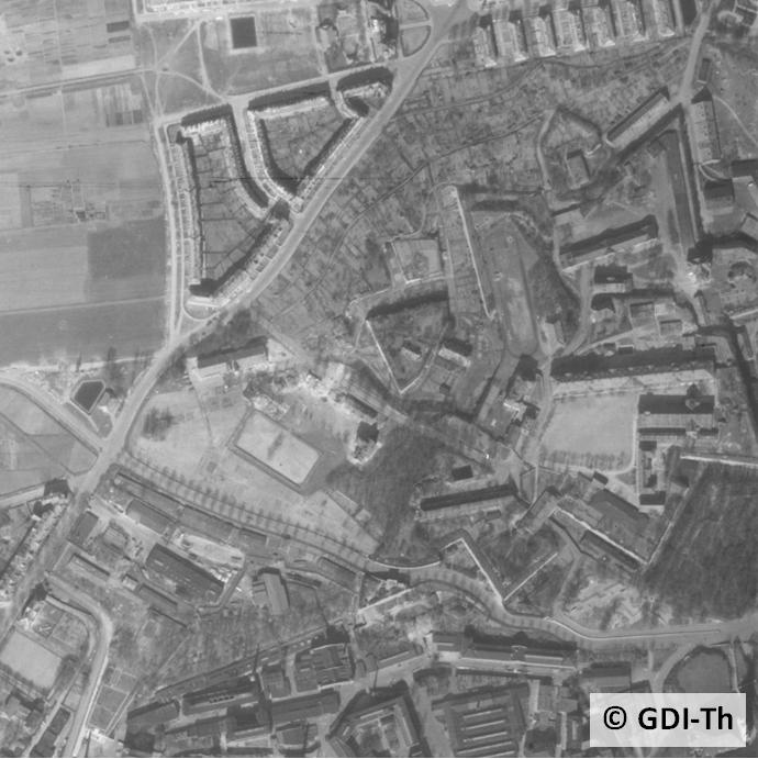
Digitale Luftbilder
Digitale Luftbilder sind verkleinerte photographische Abbilder eines Teiles der Erdoberfläche. Sie werden aus Flugzeugen mit Spezialkameras im Allgemeinen senkrecht nach unten aufgenommen. Das Gelände wird im Luftbild verzerrt dargestellt. Luftbilder besitzen keinen einheitlichen Maßstab und keine Georeferenzierung.
Das digitale Luftbild ist eine Grauwertmatrix, es entsteht durch Scannen des Bildes. Gescannt wird mit einer Auflösung von ca. 1700 dpi (15 Mikrometer).
Zusatzliche Informationen
amtliche Luftbilder, Angabe der Bildnummer und Bildflugnummer
|
|
Citation proposal
. Digitale Luftbilder. https://gdk.gdi-de.org/geonetwork/srv/api/records/2af1a7e2-b1a6-4ee3-80de-07c836d5e784 |
INSPIRE
Identification
- File identifier
- 2af1a7e2-b1a6-4ee3-80de-07c836d5e784 XML
- Hierarchy level
- Dataset
Online resource
- Protocol
- WWW:LINK-1.0-http--download
- Protocol
- WWW:LINK-1.0-http--link
Resource identifier
- Metadata language
- German
- Spatial representation type
- Grid
Encoding
- Format
- TIFF, JPG
- Version
- 1
Projection
- code
- EPSG:25832, EPSG:31468
Classification of data and services
- Topic category
-
- Imagery base maps earth cover
Classification of data and services
Coupled resource
Coupled resource
Classification of data and services
Coupled resource
Coupled resource
Keywords
Other keywords
- Keywords
-
- Digitale Luftbilder
- Luftbild
- GOVE
- Photographisches Abbild
- Photogrammetrische Auswertearbeiten
- Geobasisdaten
- Luftbildfotographie
- AdVMIS
- Orthophoto
- opendata
Geographic coverage
))
Temporal reference
Temporal extent
Temporal extent
- Date ( Creation )
- 1994-01-01
Quality and validity
- Lineage
- Kontinuierlich landesweite Befliegung
- Distance
- 0 m
Conformity
Conformity
Conformity
Conformity
Conformity
Conformity
Restrictions on access and use
- Access constraints
- Es gelten die Lizenzbedingungen „Datenlizenz Deutschland - Namensnennung - Version 2.0“ bzw. „dl-de/by-2-0” (https://www.govdata.de/dl-de/by-2-0) mit den dort geforderten Angaben zum Quellenvermerk. Als Rechteinhaber und Bereitsteller ist die Datenhaltende Stelle, sowie das Jahr des Datenbezugs in Klammern anzugeben. Beispiel für Quellenvermerk: GDI-Th (2021) Datenlizenz Deutschland - Namensnennung - Version 2.0 (www.govdata.de/dl-de/by-2-0).
- Access constraints
-
{
"id": "dl-by-de/2.0",
"name": "Datenlizenz Deutschland Namensnennung 2.0",
"url": "https://www.govdata.de/dl-de/by-2-0",
"quelle": "© GDI-Th"
}
Restrictions on access and use
Responsible organization (s)
Contact for the resource
- Organisation name
- Thüringer Landesamt für Bodenmanagement und Geoinformation
Responsible organization (s)
Contact for the resource
- Organisation name
- Thüringer Landesamt für Bodenmanagement und Geoinformation
Metadata information
Contact for the metadata
- Organisation name
- Thüringer Landesamt für Bodenmanagement und Geoinformation
- Date stamp
- 2024-02-15T10:59:13
- Metadata language
- German
- Character set
- UTF8
SDS
Conformance class 1: invocable
Access Point URL
Endpoint URL
Technical specification
Conformance class 2: interoperable
Coordinate reference system
Quality of Service
Access constraints
Limitation
Use constraints
Limitation
Responsible custodian
Contact for the resource
Conformance class 3: harmonized
Overviews
Provided by
