 www.geodatenkatalog.de (S3L)
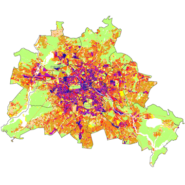
Versiegelung 2021 (Umweltatlas)
Versiegelung von Block- und Blockteilflächen in 10%-Stufen, ermittelt aus Satellitenbilddaten (Sentinel-2B, unbebauter Anteil) und Gebäudedaten (bebauter Anteil), sowie von Straßenflächen, ermittelt aus Straßenbefahrungsdaten, auf Grundlage der Blockkarte 1 : 5.000 (ISU5), Stand 2020. Zudem wird die Veränderungskartierung im Vergleich von 2016 zu 2021 dargestellt. Die Rasterkarte ist ein unkorrigiertes Zwischenergebnis der Versiegelungskartierung 2021. Dargestellt ist das Ergebnis der regelbasierten Klassifizierung der Satellitendaten (Sentinel-2B-Szene Juni 2021).
|
|
Citation proposal
(2022) . Versiegelung 2021 (Umweltatlas). https://gdk.gdi-de.org/geonetwork/srv/api/records/2c8a769b-364e-4596-ace4-4c05cd8eb872 |
INSPIRE
Identification
- File identifier
- 2c8a769b-364e-4596-ace4-4c05cd8eb872 XML
- Hierarchy level
- Dataset
Online resource
Resource identifier
- Metadata language
- German
- Spatial representation type
- Text, table
Encoding
- Format
- text/html
- Version
- 4.01
- Specification
- keine Angabe
Projection
Classification of data and services
- Topic category
-
- Imagery base maps earth cover
Classification of data and services
Coupled resource
Coupled resource
Classification of data and services
Coupled resource
Coupled resource
Keywords
- GEMET - INSPIRE themes, version 1.0 ( Theme )
-
- Bodenbedeckung
- Spatial scope
Other keywords
- Keywords ( Theme )
-
- inspireidentifiziert
- open data
- opendata
- Geodaten
- Berlin
- Umweltatlas
- Luftbildauswertung
- Satellitenbildauswertung
- Versiegelungsklassen
- ALKIS
- Sentinel-2A
- Gebäude
- bebaut
- versiegelt
- Veränderungskartierung
- Monitoring
- unbebaut
- Straßen
Geographic coverage
N
S
E
W
))
Temporal reference
Temporal extent
Temporal extent
- Date ( Publication )
- 2022-11-01
Quality and validity
- Lineage
-
- Informationssystem Stadt und Umwelt (ISU5) - Raumbezug und Flächennutzungsdaten (Stand 31.12.2020)
- Amtliches Liegenschaftskatasterinformationssystem - ALKIS (Stand 02/2022)
- NOT-ALKIS Gebäude (Stand 2021)
- Karte von Berlin 1 : 5.000 - K5 (Stand 05/2021)
- Orthophotos 2020 und 2021 (Stand 08/2020 und 02/2021)
- Daten der Berliner Wasserbetriebe (Stand 2001)
- Straßenbefahrungsdaten (Stand 2014)
- Multispektrale Sentinel 2B-Szene vom 07.06.2021
Conformity
Conformity
Conformity
Conformity
Conformity
Conformity
Restrictions on access and use
- Access constraints
- Für die Nutzung der Daten ist die Datenlizenz Deutschland - Zero - Version 2.0 anzuwenden. Die Lizenz ist über https://www.govdata.de/dl-de/zero-2-0 abrufbar.
- Access constraints
- { "id": "dl-zero-de/2.0" , "name": "Datenlizenz Deutschland - Zero - Version 2.0", "url": "https://www.govdata.de/dl-de/zero-2-0" }
Restrictions on access and use
Responsible organization (s)
Contact for the resource
- Organisation name
- Senatsverwaltung für Stadtentwicklung, Bauen und Wohnen Berlin
Responsible organization (s)
Contact for the resource
- Organisation name
- Senatsverwaltung für Stadtentwicklung, Bauen und Wohnen Berlin
Metadata information
Contact for the metadata
- Organisation name
- Senatsverwaltung für Stadtentwicklung, Bauen und Wohnen Berlin
- Date stamp
- 2025-03-06T12:33:29
- Metadata language
- German
- Character set
- UTF8
SDS
Conformance class 1: invocable
Access Point URL
Endpoint URL
Technical specification
Conformance class 2: interoperable
Coordinate reference system
Quality of Service
Access constraints
Limitation
Use constraints
Limitation
Responsible custodian
Contact for the resource
Conformance class 3: harmonized
Overviews
Provided by

Views
2c8a769b-364e-4596-ace4-4c05cd8eb872
Access to the portal
Read here the full details and access to the data.
Associated resources
Not available