 My GeoNetwork catalogue
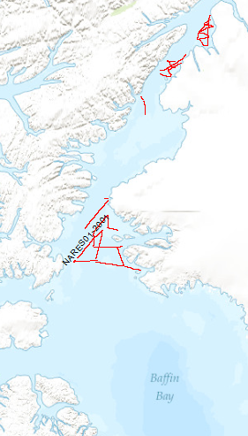
Processed seismic data of Cruise Nares 2001
The Scientific staff and crew onboard CCGS Louis S. St. Laurent (LSL) returned September the 10th, 2001 from a scientific expedition to the Nares Strait, the northernmost waterway connecting the Arctic and Atlantic oceans. The data format is Society of Exploration Geophysicists SEG Y. The ice conditions in the strait required the support of Canada's largest ice breaker. The ship was a versatile platform for 34 scientists to accomplish their marine investigation. The LSL has a history of supporting international scientific expeditions including an oceanographic transect of the Arctic Ocean in 1994 and a biological study of the Canadian Arctic Islands in 1999. Germany (Bundesanstalt für Geowissenschaften und Rohstoffe, BGR) and Canada (Geological Survey of Canada) undertook a 5-week scientific cruise to study and explore the geological structure and evolution of the Nares Strait. The primary objective was the study of structural features relating to the formation of the Arctic Ocean and, in particular, the study of the Wegener Fault. This fault is a linear boundary between Greenland and Ellesmere Island which was noted by the German scientist Alfred Wegener in 1915 and later became the subject of a major scientific controversy. The co-operative cruise, which was planned over a period of 2 years, provided the basis for a wide range of scientific investigations, from marine seismic work and climate change studies through airborne magnetic investigations to geodetic survey measurements and geological sampling onshore. Systematic geophysical offshore studies in this key area had not been undertaken before. Where towing of seismic equipment was not possible because of ice coverage, magnetic maps were made using a helicopter-borne magnetic sensor system. Sediment and water samples taken during the cruise provide information on changes in climate and sea ice cover from the last ice-age to the present. An 11 m-long sediment core from outer Jones Sound is the longest core ever taken in the Canadian Arctic channels and holds clues to the detailed climate history of northern Baffin Bay.
Simple
- Alternate title
-
Nares01 2001
- Date (Creation)
- 2015-08-11
- Citation identifier
- b3ba9ed0-c65b-4e43-b829-b891281f0d51
- Status
- Completed
-
GEMET - INSPIRE themes, version 1.0
-
-
geology
-
Geologie
-
-
GEMET - Concepts, version 2.4
-
-
marine geology
-
Meeresgeologie
-
geophysics
-
Geophysik
-
raw material
-
Rohstoff
-
- Theme
-
-
seismics
-
Seismik
-
two-dimensional seismic reflection
-
zweidimensionale Reflektionsseismik
-
MSSP
-
- Place
-
-
Labrador Sea
-
Labradorsee
-
- Access constraints
- Other restrictions
- Other constraints
- Es gelten keine Zugriffsbeschränkungen
- Use constraints
- Other restrictions
- Other constraints
-
Allgemeine Geschäftsbedingungen, siehe https://www.bgr.bund.de/AGB - General terms and conditions, see https://www.bgr.bund.de/AGB_en . Die bereitgestellten Informationen sind bei Weiterverwendung wie folgt zu zitieren: Datenquelle: Nares01, (c) BGR, Hannover, 2001
- Spatial representation type
- Vector
- Language
- English
- Character set
- UTF8
- Topic category
-
- Geoscientific information
))
- Unique resource identifier
- EPSG:4326
- Distribution format
-
-
Shapefile
(
n/a
)
-
Shapefile
(
n/a
)
- Transfer size
- 1
- OnLine resource
-
Nares01 2001 (Shapefile)
Nares01 2001 im Format ESRI Shape
- OnLine resource
- Profil NARES01-01
- OnLine resource
- Profil NARES01-02
- OnLine resource
- Profil NARES01-02A
- OnLine resource
- Profil NARES01-04
- OnLine resource
- Profil NARES01-05
- OnLine resource
- Profil NARES01-06
- OnLine resource
- Profil NARES01-07
- OnLine resource
- Profil NARES01-08
- OnLine resource
- Profil NARES01-09
- OnLine resource
- Profil NARES01-10
- OnLine resource
- Profil NARES01-11
- OnLine resource
- Profil NARES01-12
- OnLine resource
- Profil NARES01-13
- OnLine resource
- Profil NARES01-14
- OnLine resource
- Profil NARES01-15
- OnLine resource
- Profil NARES01-16
- OnLine resource
- Profil NARES01-17
- OnLine resource
- Profil NARES01-18
- OnLine resource
- Profil NARES01-19
- OnLine resource
- Profil NARES01-20
- OnLine resource
- Profil NARES01-21
- OnLine resource
- Profil NARES01-21A
- OnLine resource
- Profil NARES01-22
- OnLine resource
- Profil NARES01-23
- OnLine resource
- Profil NARES01-24
- OnLine resource
- Profil NARES01-25
- OnLine resource
- Profil NARES01-26
- OnLine resource
- Profil NARES01-27
- OnLine resource
- Profil NARES01-28
- OnLine resource
- Profil NARES01-29
- OnLine resource
- Profil NARES01-30
- OnLine resource
- Karte im BGR-Geoviewer
- Hierarchy level
- Dataset
Conformance result
- Date (Publication)
- 2010-12-08
- Explanation
-
siehe dazu die angegebene Durchführungsbestimmung
- Statement
-
During the period from 11th of August to 8th of September 2001 BGR aquired seismic lines in the Labrador Sea. The lines Nares01-02, Nares01-02A, Nares01-04, Nares01-05, Nares01-06, Nares01-07, Nares01-08, Nares01-09, Nares01-10, Nares01-11, Nares01-12, Nares01-13, Nares01-14, Nares01-15, Nares01-16, Nares01-17, Nares01-18, Nares01-19, Nares01-20, Nares01-21, Nares01-22, Nares01-23, Nares01-24, Nares01-25, Nares01-26, Nares01-27, Nares01-28, Nares01-29, Nares01-30 are processed (stack) data, whereas lines Nares01-01 and Nares01-21A are raw data.
- File identifier
- 2dbfff6e-2f56-4353-91b1-9de9cb49df6d XML
- Metadata language
- English
- Character set
- UTF8
- Parent identifier
-
Marine Seismic Survey Profiles (MSSP)
06a73c56-06a2-40d8-b806-466222b0760d
- Hierarchy level
- Dataset
- Hierarchy level name
-
Geophysik
- Date stamp
- 2025-04-07
- Metadata standard name
-
INSPIRE Metadata Implementing Rules: Technical Guidelines based on EN ISO 19115 and EN ISO 19119
- Metadata standard version
-
n/a
Overviews
Spatial extent
Provided by
